2:09 A.M. (Yikes!)
First off, let me say that I first posted this blog on http://www.weatheron.net/western-washington-blog.html, and then made a couple edits and posted it here. Take a look at WeatherOn and you'll find some pretty cool stuff. Tanner has been working hard on the site and it looks really, really good!

The above picture was taken by the Bureau of Land Management in California on September 5, 2008. California commonly experiences wildfires, but Washington, particularly Eastern Washington, is not immune to them either.
I was absent the past week for a fishing trip in Canada and knew that Washington was expected to receive some rain. At the time I left, forecasts were calling for over an inch of rain in areas of Western Washington and perhaps up to FIVE INCHES in parts of the Cascades. The measured rainfall totals, however, were much lower - Seattle has only received 0.08 inches of rain this month, which is below the August average-to-date value of 0.13 inches. July was extraordinarily dry, so it goes without saying that forests and soils still have lower-than-average water content, which increases their susceptibility to wildfires.
Over the years I have watched the weather, there seem to be two distinct weather patterns that cause wildfires to form. The first is one that California sees often and we see a couple times each summer - hot downslope winds off mountain ranges in dry areas where even a spark can set a raging fire (although mountains are not necessary... the Great Plains can see massive wildfires as well under this setup). The second is the type we will see - dry conditions antecedent to thunderstorms. In this type of setup, fires can be caused completely naturally by lightning strikes igniting trees. Thunderstorms often have gusty winds to fuel the fires, and these thunderstorms, particularly the ones in the west, have a tendency to produce prodigious amounts of lightning while producing relatively little rainfall. They generally produce little rainfall because they form in dry conditions and have high cloud bases, and because their bases are so high, much of the rain they produce evaporates into the dry air below and only a slight percentage of it reaches the ground. Thankfully, we may see some decent precipitation as the upper low providing the instability and moisture for these storms is also forecast to provide some periods of rain not associated with daytime convection and these high and dry storms.with these storms, and that should help mitigate wildfires around the area.
The general synopsis is that an upper level low currently over Northern California will drift north and bring a relatively moist and unstable air mass with it. Daytime heating will support the development of thunderstorms over the Cascade foothills, where the air will be most unstable, and a couple of these storms could drift eastward into the lowlands as the afternoon transitions to evening. In other words, thunderstorms will form over the Cascades each afternoon before slowly moving eastward into the lowlands. I'll post some model charts below of the three-hour precipitation totals at certain times of the day, and I want you to try to pick out the pattern of showers forming over the Cascades.
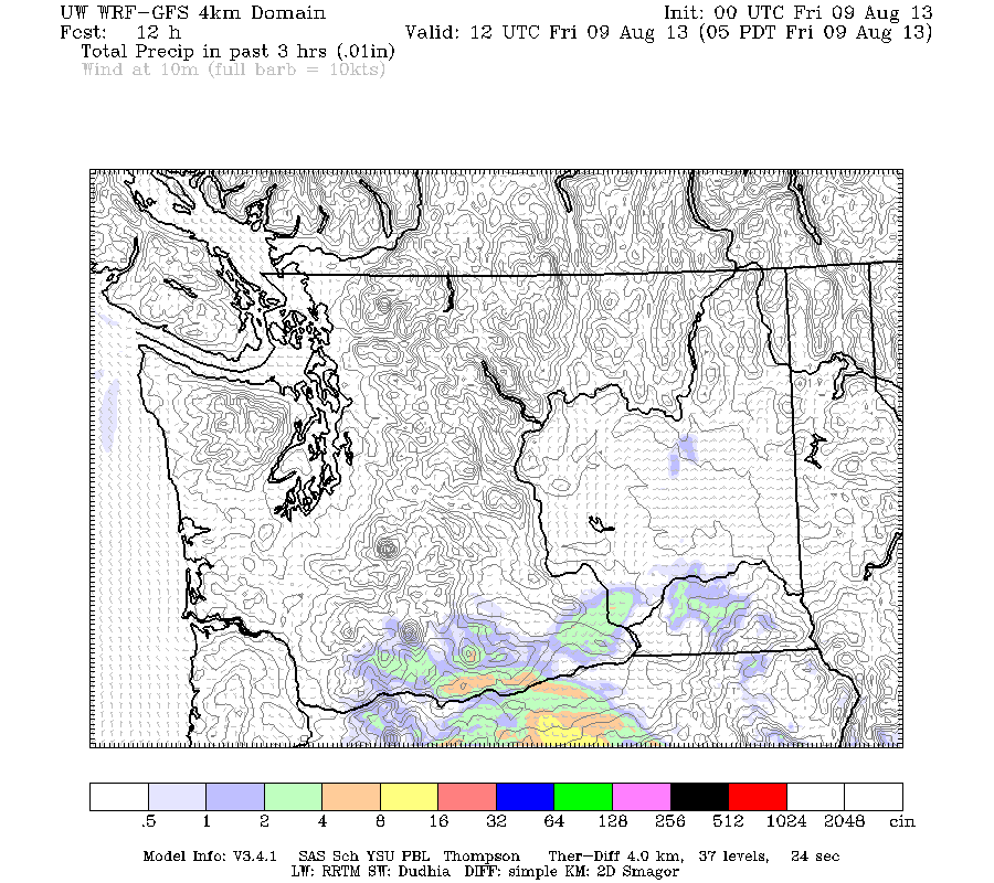 |
| Valid 05:00 am PDT, Fri 09 Aug 2013 - 12hr Fcst: UW 8/8/13 00z WRF-GFS: 4km Washington 3-hour Precipitation |
Here's a chart for 5 A.M. on the 9th. There are a couple showers associated with the low to the south, but nothing over the Cascades. But take a look 12 hours later.
 | |||||||||||||||||||||
| Valid 05:00 pm PDT, Fri 09 Aug 2013 - 24hr Fcst: UW 8/8/13 00z WRF-GFS: 4km Washington 3-hour Precipitation |
Thunderstorms all over the Cascades! And mind you, these storms are only dropping a tenth of an inch of rain over three hours. They are dry, dry storms. And as you will see in the picture below, they will drift into the lowlands in the evening into the night.
 |
| Valid 11:00 pm PDT, Fri 09 Aug 2013 - 30hr Fcst: UW 8/8/13 00z WRF-GFS: 4km Washington 3-hour Precipitation |
The next couple mornings will be slightly different as some rain from the upper level low spins into the lowlands, but the mountains will see this same pattern continue on Saturday and Sunday before a more marine regime (no rhyme intended) takes control on Monday.
Until then, take precautions if you have a home or property that is vulnerable to these fires. My family shares some property with other partners up by Cle Elum on the eastern foothills of the Cascades, and a fire almost infiltrated some of the land but was stopped short by some sort of gravel road or ditch just outside our property. Those in the lowlands may get a fantastic light show to the east at night, so keep your eyes to the east. I'd expect to see some pretty brilliant cloud-to-cloud lightning flashes.
Enjoy the weekend, and thanks for reading my blog!
Charlie Phillips
No comments:
Post a Comment