Wednesday, October 27, 2010

Putting that Big Midwest Storm in Perspective

October 27, 2010
1:59 P.M.


Look at that storm!!!


Now, many of you may have heard about the huge storm in the Midwest. There has been a lot of talk about it being the strongest extratropical storm on record on the contiguous 48 states. The media generally says it is. However, many of the local weather guys around here say no. Who should you believe? Well, you should believe me, and both sides have valid points.


This storm officially has the lowest pressure ever recorded by an extratropical cyclone on the contiguous 48 states. The mercury bottomed out at 28.20" (954.9 millibars) in Bigfork, Minnesota yesterday at around 5:13 CDT. This is an official, all time record. Now, note that I respect Cliff Mass very much and regard him as a GOD, but I think he is mistaken when he says that we have had the deepest storms. We have had some very deep storms - the most recent example being a storm from December 12, 1995.  According to Wolf Read that storm probably bottomed out at 953 millibars, (see my Storm King website link - he has put together a fantastic website of historical Pacific Northwest) which is deeper than this storm, but by the time it reached land, it was above 955, and I think the lowest actual measured pressure was like 958 mb or something. So that storm is not the deepest storm to hit the continental U.S. There may be a storm back in January 1880 (which has been nicknamed "The Storm King" itself) that may have been deeper, but there is not a real official reading. So the record belongs to Bigfork. What a funny name for a town.


BUT... our windstorms are stronger than theirs by far. Why? Because our storms are more compact and have  stronger pressure gradients. Look how big the storm is in that satellite photo. The winds cover a huge area. However, since they cover such a big area, they are also less extreme. The pressure gradients drive the winds, and if the storm is bigger and the pressure gradients are more relaxed, the winds are not going to be as strong. There was an 81 mile-per-hour gust and it made national headlines. I think that's pathetic, personally. That really is not that fast. The coast sees gusts like that every winter, and even Puget Sound gets them sometimes. 


A great example to show how our storms are more compact than the ones over the rest of the nation is our "Intense Cyclone of November 3, 1958." 


This is from Wolf Read's website. This storm was only 985 mb, yet it produced a 161 mph gust. Contrast that to a 955 mb storm that produced a 81 mph gust. This clearly shows the difference in wind velocity between the two storms. Our wind velocity is higher because this cyclone was much more compact.


But no windstorm can even approach the Columbus Day Storm in terms of wind speeds. 


Gusts of 116 in downtown Portland, 127 in Corvallis, 160 at the Naselle Radar site (it commonly gets really windy there), 170 in the Tillamook Forest, 150 SUSTAINED at Cape Blanco with gusts to 179, or they may have been as high as 195, as one of my many weather books estimates. Renton got to 100. Newport got to 138. The list just goes on and on. THIS is the "perfect storm." Not that 1991 weak thingy. The "Perfect Storm" of 1991 had a peak gust of 85, and that was at a coastal station. There is a possible 110 mile-per-hour difference in peak wind gusts. So much for the "Perfect Storm!" When you add that on to the fact that the Pacific Northwest has tons of huge, shallow rooted trees to blow down and the Northeast has a lot less, you wonder where that storm got that name in the first place. Here are some Columbus Day photographs to give you an idea of the damage. Everything is from Wolf Read.


There is one thing that those easterners do have on us though in the "who has more gnarly extratropical cyclones" and that is severe thunderstorms. Their cyclones produce severe thunderstorms. This last one produced a little over 20 tornadoes, and although I don't think any of these tornadoes were huge, there was one storm that produced a huge tornado outbreak. April 3, 1974 was a date that will live in infamy as the largest tornado outbreak ever recorded. And these tornadoes were strong. 315 people died and over 5,000 were injured. 


Take a look at this tornado. It hit Xenia, Ohio as an F5 with estimated 300 mph winds and completely decimated the town.


So, the most damaging event was not the Columbus Day Storm or the one that we just saw over the Midwest.  It was the "Super Outbreak" of 1974! A great website to learn more about this outbreak is http://www.april31974.com/. When people talk about the strength of extra-tropical cyclones, they are generally talking about wind speed that is associated with the pressure gradients directly. In that case, the Columbus Day Storm outshines everything else by several orders of magnitude. But the Super Outbreak was a horrifically powerful weather event in a different way, and that's why I am calling it the most destructive extratropical storm the United States has seen in the last 110 years.


Oh yeah... a weather forecast.
We could see flooding next week. Stay tuned...
Charlie Phillips, over and out.

Sunday, October 24, 2010

And... Storm Season is Underway!

October 24, 2010
10:21 P.M.

I hope you guys like the new blogger template by the way. I don't care for it too much but it is a newer update so I can do more stuff, like put bigger pictures on it and stuff. I'm a fan of bigger pictures. 'merica, right? Bigger is better.

However, if you happened to be kayaking off the Washington Coast this weekend, you would probably disagree with me. The huge waves that we've been advertising for a while are hitting the beaches. These waves are not just large, they are gigantic. The average significant wave height is expected to be 33.5 feet off the coast tonight and tomorrow. As far as I can remember, there has only been one event with bigger waves, and that was when 44-foot average waves were recorded with individual heights as high as 70 feet during the December 2007 Great Coastal Gale (crazy windy on coast, not windy here, flooding everywhere). There's still a 10 foot difference in the wave heights though, which just serves to show how intense the 2007 storm was.

Snoqualmie Pass is getting a rain-snow mix, and Stevens Pass is all snow. I gotta go to bed (school tomorrow!) but we may have some more interesting weather at the end of the week. I'll keep you posted.
Charlie :)

Saturday, October 23, 2010

Big Coastal Storm on the Way!

October 23, 2010
2:01 P.M.

Many of you guys probably noticed that I didn't update the blog the last couple days. I had a ton of homework. I'm not taking the easy way out of high school, I'm taking some really advanced classes so I can get into some good colleges. Then it will be a matter of seeing how much money they give me (I don't care what college you go to, 50,000 dollars a year is a scam). But yes, we have a major storm slated for later tonight that will give the coast some huge waves, as well as giving some wind inland and some rain both in the mountains and lowlands. The Cascades could see their first significant snowfall of the season with this storm as well. First, though, let's look at the water vapor imagery to give you an idea of what is really the driving force behind this storm.

You can see the beginnings of the low-pressure system starting to form. There is a bent-back occlusion and a strong "dry slot" to the south of the center of the low. What is even more impressive to me, however, is the visible jet stream in the water vapor imagery all across the Pacific. You want to know what zonal flow is? THAT, my friends, is zonal flow. The jet stream is extremely powerful and centered right across the Pacific, and it has tapped into a ton of moisture (most of it from that big supertyphoon, Megi, which actually got down to 895 mb with 180 mph sustained winds!). Very, very impressive water vapor imagery from our satellites.

But what's the actual forecast? This graphic should sum it up.

Waves! Look at those wave heights! 40 foot waves could batter the central Washington coast! That is just astounding. I've seen higher waves (December 2007 - average recorded height at a buoy by the Columbia was 44 foot waves with individual ones as high as 70 feet before the buoy became unmoored) but these are still extraordinary wave heights. I'm trying to convince my mom to take me to La Push tomorrow to witness these waves but she says absolutely not.

Some of the coastal areas have storm warnings, Willapa Bay southward has a high-wind warning (coast only), the Skokomish River might get flooded, and the mountains even have winter storm watches! As I've been advertising for a while, the mountains above 4000 feet could get a real dose of snow. I would not be surprised if they got a foot from the highly unstable air that will be filtering in Sunday night after this big event is over. The air temperatures in the upper atmosphere will be cool enough to support snow at the higher passes. I think Snoqualmie Pass will see a rain-snow mix, but would happily be proven wrong. For those of you who ski at Alpental, the upper mountain should get a good dumping! Because of the snow, there will be no flooding concerns on the Cascades.

Sit back and enjoy the show folks! What a way to kick off the storm season!

Wednesday, October 20, 2010

Storm Details Uncertain

October 20, 2010
4:34 P.M.

The details on the storms this weekend are still very, very murky. The American models, the GFS and the NAM, have been forecasting a large low pressure system to bottom out in the Gulf of Alaska at around 950 millibars, sending a strong front right into our area. This is a very deep low, but, surprisingly, these type of events are not all that uncommon where sub-950 millibar lows intensify until they kind of stall in the Gulf of Alaska. Here is a picture of the mm5-GFS model for 5 P.M. Saturday.


It is pretty similar to what we have been seeing all along. The coast has the best chance at getting high winds with this storm, and I wouldn't be surprised to see a stray 70 mile per hour gust, especially at Tattoosh Island. Gusts inland will be in the 30-40 mile per hour range. 

Now, let's look at the Canadian model, which is showing a scenario that would give us some wind. This model takes that one big storms and splits it into two smaller storms, but they come right at us. The same sounds true with the Euro, although since I'm not in the NWS I don't really have good access to that model. Here is the 00UTC Monday map (around 4 P.M. local time I think)


As you can see there is a powerful 965 mb cyclone slamming right into us. That would give us high winds. The latest GFS also *kind of* follows this, though the storm is further north and it kind of fizzles out before hitting us, stll giving us lots of rain and wind but not windstorm-type winds. One thing is for sure - the Cascades above 4000 feet will get a LOT of snow from this storm, and I think Snoqualmie Pass will end up getting some too.

The NWS guys will be busy over the next couple days. Come to think of it, so will I. :)

Tuesday, October 19, 2010

It's Gonna Get Bad, but Where and How Stormy?

October 19, 2010
5:24 P.M.

Well, the models have been all over the place over the past few runs with what they are showing, and I know exactly why. First, the jet stream is very strong, and although models are good at picking up this pattern, they have a hard time pinning down what storms will affect which areas at which time. Often, when the models are as inconsistent as they are now, meteorologists will "broadbrush" the forecast, meaning they say it will be wet but don't give any specific details. Usually it is reserved for longer range forecasts outside of a week or so, and this storm is expected to come in Saturday night. However, due to the inconsistencies in the models, the NWS guys are just saying it is gonna be wet and giving more details later. Another reason is that the NWS confirmed that tropical moisture IS going to be entrained in this system (I called it!) from supertyphoon Megi, which once had a central pressure of 895 millibars and sustained winds of 180 miles per hour! Obviously, that powerful of a storm is going to offer some very deep tropical moisture, and just how much of it gets entrained in the jet stream is going to make a huge difference on what kind of a storm we will see. Our models generally have issues pinning down details when tropical moisture is involved.

The trend over the last few model runs has been to put the heaviest precipitation in California. We will see if this comes true. Washington will still get a good soaking though, and there could be very strong winds out on the coast and at least blustery winds inland. Here's the 24 hour precip ending at 5 P.M. Sunday. Lots of 10+ inch totals in the mountains of Northern California.


Beyond, models still show active stuff, but I'm not going to give any details because they will change. It will, however, be wet and windy. There's a broadbrush forecast!
Charlie

Monday, October 18, 2010

Pacific Storm Train Update

October 18, 2010
4:04 P.M.

So, that strong surface low that looked like it was going to plow right into Western Washington has gone away, but the models are still showing an active pattern with a lot of rain possible. Here are some shots from this morning's MM5-GFS run (12 UTC cycle).

You can see the beginnings of a storm on the left (where all the precipitation is). I don't know if this moisture is fed from tropical sources but it looks like it is at the very least subtropical. Of course, it is being driven by a very strong jet stream directly westward and that is what will allow it to strengthen.

The next image shows it in the process of what is called "explosive cyclogenesis," or as seasoned meteorologists around here say, "bombing." This basically means that the central pressure of the low is dropping rapidly and the system is quickly increasing in intensity.

As you can see, the occluded front is well-formed, there is a very strong and moist warm front out ahead of
the system, and there is a long cold front trailing behind it. And look where the bulk of the moisture goes!

... you guessed it - right into Western Washington. In fact, from 5 P.M. Saturday to 5 P.M. Sunday, some places could see 2-5 inches of rain, perhaps up to 8 inches in the wettest spots, as the red in the graphic below shows.
Seattle may be rain-shadowed though, especially north Seattle, and might not see much at all. It is VERY important to point that out - weather forecasters often do not communicate things like rain shadows very well to the public, so when Seattle ends up getting very little rain they are not surprised while the rest of the city just thinks the weather forecasters got it wrong... again. That's something all weather forecasters need to do. However, from this graphic, it looks like Seattle will still get a good amount of rain, but you can see a sizable shadow with a bullseye around the Kingston area.

Remember, this is only one possible scenario. Other models are not showing this situation quite yet, so we might end up with a fairly dry day (though we would probably still see some rain). But it is never fun to analyze those models. I guess we will just have to wait and see how everything unfolds! It's that time of year...
Charlie

Sunday, October 17, 2010

Pacific Storm Train Ramping Up?

October 17, 2010
Hey everybody, thanks for continuing to read my blog, it means a lot. I know I've not been writing for a while, that generally means I just have a bunch of homework to do, as was the case this past week. I still have a ton of homework to do, but I thought I'd write a little update on what we can expect weather-wise the coming week and beyond. Just remember that when I'm not writing, it's because I'm busy, not because I've forgotten about the blog or suddenly lost interest in weather. You just have to straighten out your priorities, you know?

This is an image of the jetstream over our area (more specifically, the winds at the 300 millibar level in the atmosphere). As you can see, it is aimed right at us, and when we have the jet stream aimed right at us, the "Pacific Storm Train" occurs. If you remember either January or November 2006, it is easy to see why they have given it this name. Once the "door is open" (that is, there is no blocking ridge of high pressure and the jet stream is pointed directly at us), storm after storm after storm can hit the Pacific Northwest. These storms are usually strong and progressive, which means that they can bring a lot of wind, rain, and snow for several hours, then they will pass, only to have another storm arrive several hours later. Flooding is generally not a huge issue with this type of zonal flow because snow levels are lower than if the jet stream had a more southerly component and the periods of rain are usually shorter with more breaks between them. However, we can still get flooding rains, don't misinterpret what I am saying. They are just more likely in a setup that is not as fast or progressive and where the jet stream dips down towards Hawaii and is then shunted in our direction by a ridge of high pressure to our south. Pineapple Express (flooding) events are often triggered by a pattern in the tropics called the Madden-Julian Oscillation, but I will talk about that at a different time.


In the meantime, take a look at some of the forecast images from the GFS model that show a potential windstorm about a week from now and a very strong jet. Normally I would just discount this individual windstorm and say we are just going to be in an active pattern, but the models have been very consistent with this individual storm. And yes, I finally found out how to make everything clickable, so now you can actually get a good idea of what is going on because you will be able to see the pictures at the right size! Thanks for looking and savor your sunshine while it lasts folks because it looks like we are going to get stormy.
Charlie

Thursday, October 7, 2010

A Little Bit of Housekeeping and a child abduction emergency

Hey Everybody! I just put pretty much all the stuff I ever posted on my facebook blog which I am no longer using (http://www.facebook.com/group.php?gid=33875355514)
on to this website. I put them in posts organized by months and it goes back to April 2008. So yeah, feel free to take a look at them! There aren't any pictures though. :(
That's what makes blogger so good though. :)

And what about this child abduction emergency? Well look what I found on the national weather service website. The yellow for the state of montana? That is a "Child Abduction Emergency"


BULLETIN - EAS ACTIVATION REQUESTED
CHILD ABDUCTION EMERGENCY
MONTANA DEPARTMENT OF JUSTICE
RELAYED BY NATIONAL WEATHER SERVICE GREAT FALLS MT
1010 PM MDT WED OCT 6 2010

THE FOLLOWING MESSAGE IS TRANSMITTED AT THE REQUEST OF THE
MONTANA DEPARTMENT OF JUSTICE.

THIS IS AN ACTIVATION OF THE AMBER ALERT SYSTEM.

THE ALERT IS ISSUED ON BEHALF OF THE STATE OF WASHINGTON. WE HAVE
JUST RECEIVED THIS IMPORTANT INFORMATION REGARDING ABDUCTED
CHILDREN IN SPOKANE...WASHINGTON...SPOKANE COUNTY. WASHINGTON
STATE POLICE IN SPOKANE...DISTRICT FOUR...ARE LOOKING FOR
CHILDREN WHO WERE LAST SEEN AT WEST 1100 MALLON IN
SPOKANE...WASHINGTON...AND ARE BELIEVED TO BE IN DANGER. THE
CHILDREN/S NAMES ARE...

KALEB PHILLIPS...HE IS A 10 YEAR OLD WHITE MALE WITH BLONDE HAIR
AND BLUE EYES. HE IS BELIEVED TO BE FOUR FEET...WEIGHING 80 POUNDS.

DAWSON PHILLIPS...HE IS AN 8 YEAR OLD WHITE MALE WITH BLONDE HAIR
AND BLUE EYES. HE IS BELIEVED TO BE THREE FEET...WEIGHING 60 POUNDS.

BISHOP PHILLIPS...HE IS A 6 YEAR OLD WHITE MALE WITH BLONDE HAIR
AND BLUE EYES. HE IS BELIEVED TO BE THREE FEET...WEIGHING 50
POUNDS.

AUTHORITIES SAY THAT THE CHILDREN MAY BE IN THE COMPANY OF CHAD
PHILLIPS...HE IS A 33 YEAR OLD WHITE MALE WITH BLONDE HAIR AND
BLUE EYES. HE IS BELIEVED TO BE FIVE FEET...10 INCHES
TALL...WEIGHING 180 POUNDS. THEY MAY BE TRAVELING IN A 1996 DARK
GREEN CHEVROLET MONTE CARLO VEHICLE...INDIANA LICENSE NUMBER
IU4676. IF YOU HAVE ANY INFORMATION ON THE WHEREABOUTS OF THESE
CHILDREN...PLEASE CONTACT 509-456-2233 IMMEDIATELY.
My prayers go out to these children, and I hope they return safely. It is weird that the person beleived to have abducted them is Chad (nickname for Charlie) Phillips. I think it is kind of strange and a little funny that this is on a weather website, but child abduction itself is no laughing matter, and I will be praying for the welfare of these children. Just something I've never seen before.
Have a nice night (or good morning if you would prefer),
Charlie

What is El Nino Southern Oscillation? (ENSO)

El Nino and La Nina are both part of the El Nino Southern Oscilliation (ENSO) pattern in the eastern tropical Pacific ocean. This oscillation, or switching, refers to the temperature of the water in that region. In a La Nina phase, the water temperatures are cooler than normal, and in an El Nino phase, the water temperatures are warmer than normal. This is because in a La Nina phase, there is more upwelling in the eastern tropical Pacific, which brings cool, nutrient rich water up from the depths to the surface, and in an El Nino phase, there is decreased upwelling, so the water is more sterile and warmer. El Nino and La Nina both have different effects around the world, but since there are so many, I'm just going to talk about their effects in our location, the Pacific Northwest. Generally, El Nino will make us warmer and drier, while La Nina will make us cooler and wetter. Unfortunately for skiers, it looks like this year will be an El Nino year, with warmer and drier conditions prevailing during the winter. Still, we live in the Pacific Northwest, so we should get a good amount of snow anyway. And if there is no snow here this year, you can always head south to California during an El Nino year because the storm track is centered over them in El Nino years as opposed to us. In a La Nina year, the mountains get tons of snow because we are both wetter and cooler than normal. Especially in La Nina years, upper-level trofts from the Gulf of Alaska slide down south and direct cool and unstable air into our state. The Seattle metropolitan area usually is shadowed by these events, but the Cascades, who are perpendicular to this flow, commonly pick up foot after foot of snow. That is what happened during the 2007-2008 ski season, when Alpental, my local ski area, picked up 50 feet of snow. One interesting thing about El Nino and La Nina is that we generally do not have windstorms on these years. However, we can still get "Pineapple Express" flood events with El Nino and La Nina years.
Here's a great website to check out the tropical Pacific and see what it is doing. http://www.cpc.ncep.noaa.gov/products/analysis_monitoring/enso_update/sstanim.shtml
Somebody asked me about the probability of Pineapple Expresses in El Nino years as opposed to others, and here was my response.
Pineapple express events can happen in the El Nino, La Nina, and neutral phases of the ENSO, but they are most common in weak El Nino or neutral phases. Most Pineapple Express events are first set off by the Madden-Julian Oscillation. MJOs are pretty complex, but what they ultimately end up doing for the West Coast is bringing copious amounts of rain and warm temperatures via a long, "training" (staying in one spot, stalled) subtropical plume of moisture originating from the Hawaiian Islands or beyond (hence the name "Pineapple Express").
The thing is, in El Nino winters, a "blocking" ridge of high pressure usually sits off the Pacific Northwest, pushing the jet stream to the north and south. So while Southern Alaska and California (especially California) see enhanced precipitation, the Northwest is left dry. This means that even if an MJO produces a Pineapple Express event, it may not be pointed directly at the Pacific Northwest, which is the location most Pineapple Expresses over the past two years have been pointed. So while there may be more Pineapple Expresses, they may not be directly pointed at us.
Do you remember the huge landslides that occurred in Southern California several years back? I know for sure that they were associated with El Nino; they might have been associated with a Pineapple Express. The chance of Southern California, normally dry in the winter, getting extremely heavy rain will be much greater this year due to El Nino than other years. So if we aren't getting flooded, somebody else will be.

August 2009

August 27, 2009
1:34 P.M.

So, today I'll talk about our early autumn storms and our very tricky extended forecast. First of all, as most of you know, the tropics are very active in the months of august and september, since the warm water temperatures allow hurricanes and to develop. In October, when the northern regions have cooled significantly but the tropics are still warm, there is a large difference in temperature to support the development of extremely strong extratropical storms. Deep, tropical moisture is often entrained in low pressure systems at this time, and the differences in air temperature across the latitudes give the storm more fuel and make it stronger. The earliest major windstorm to hit the northwest, the Columbus Day Storm of 1962, was also the strongest, with gusts estimated at 195 mph at Cape Blanco, a headland on the Oregon Coast. I know this was a brief and maybe confusing explanation but frankly I just subjugated myself to an extremely intense workout and I can't really think straight right now.
The extended looks very complex. A "cut off" low pressure system (a low pressure system that stalls because it has been "cut off" from the jet stream) will heavily influence our weather over the next couple days. The models have been flip flopping a little, as these lows tend to have a mind of their own, but after a weakening system comes ashore Friday (rain will mainly stick to the coast) we will return to a pleasant late summer pattern with highs in the mid 70s and partly cloudy skies. I will be out of town Friday through Sunday to go tuna fishing. Wish me luck!
Thanks for reading,
Charlie


August 25, 2009
11:02 A.M.

Hey guys. Again, not too much new stuff to talk about. I don't know if any of you guys noticed, but there was a fairly decent marine push last night as a weak system came onshore. It opened all the doors in my house and kept me awake for a while (it was pretty loud).
Anyway, I am leaving to go tuna fishing Thursday night and I will be back late Sunday. Wish me luck! I'll have a more in-depth analysis of what to expect tomorrow, as well as some notes on what generally happens to the atmosphere when we begin the transition from summer to fall, and maybe talk about the rare but extremely powerful storms we occasionally see in early autumn.
Thanks,
Charlie

August 24, 2009
8:44 A.M.

Hey everybody. The forecast hasn't changed one bit, so I'm not going to make one right now. I hope you can understand.
Also, if you have any feedback for my blog or things you would like to see, post your ideas on the wall. It's always good to hear how this thing is working and what people want from it.
Thanks,
Charlie

August 23, 2009
9:36 A.M.

Ok, so this is the third time I've tried to write this forecast... I'm kinda sick of trying... so I'll do an update later today. My computer keeps crashing and spazzing out. Actually, what the heck I'll just do it right now and hope my computer doesn't repeat history. Anyway, there isn't really much new to talk about today as far as the short range forecast is concerned, but I thought I'd talk about El Nino and La Nina since we will be under the influence of El Nino this coming winter. El Nino and La Nina are both part of the El Nino Southern Oscilliation (ENSO) pattern in the eastern tropical Pacific ocean. This oscilliation, or switching, refers to the temperture of the water in that region. In a La Nina phase, the water temperatures are cooler than normal, and in an El Nino phase, the water temperatures are warmer than normal. This is because in a La Nina phase, there is more upwelling in the eastern tropical Pacific, which brings cool, nutrient rich water up from the depths to the surface, and in an El Nino phase, there is decreased upwelling, so the water is more sterile and warmer. El Nino and La Nina both have different effects around the world, but since there are so many, I'm just going to talk about their effects in our location, the Pacific Northwest. Generally, El Nino will make us warmer and drier, while La Nina will make us cooler and wetter. Unfortunately for skiers, it looks like this year will be an El Nino year, with warmer and drier conditions prevailing during the winter. Still, we live in the Pacific Northwest, so we should get a good amount of snow anyway. And if there is no snow here this year, you can always head south to California during an El Nino year because the storm track is centered over them in El Nino years as opposed to us. In a La Nina year, the mountains get tons of snow because we are both wetter and cooler than normal. Especially in La Nina years, upper-level trofts from the Gulf of Alaska slide down south and direct cool and unstable air into our state. The Seattle metropolitan area usually is shadowed by these events, but the Cascades, who are perpendicular to this flow, commonly pick up foot after foot of snow. That is what happened during the 2007-2008 ski season, when Alpental, my local ski area, picked up 50 feet of snow. One interesting thing about El Nino and La Nina is that we generally do not have windstorms on these years. However, we can still get "Pineapple Express" flood events with El Nino and La Nina years.
Here's a great website to check out the tropical Pacific and see what it is doing. http://www.cpc.ncep.noaa.gov/products/analysis_monitoring/enso_update/sstanim.shtml

August 22, 2009
9:05 P.M.

So I was out of town yesterday and most of today, but since I'm still back before the day is out, I thought I might entertain my friends and apprentices alike with another entry on my blog. The forecast looks pretty much the same; morning clouds and afternoon sunshine will abound. A few showers will occur Tuesday and Friday as decaying fronts, weakened by high pressure stationed over the eastern Pacific, clip our area. The extended forecast brings us warmer conditions for next weekend!
My pleasure,
Charlie

August 21, 2009
9:56 A.M.

Probably my favorite summertime weather (besides thunderstorms of course) is when we get a huge marine push after a hot spell. There's nothing I like more that sweltering in heat one day, leaving all the doors and windows open, and going to sleep with a cool refreshing breeze permeating throughout the house. Then when you wake up in the morning, you are shivering! There's no severe weather or tons of rain involved, but there is something to be said about a refreshing marine push after a stretch of hot weather. It's almost like going through microsoft word and getting all the typos out of your paper, or completely cleaning and reorganizing your room. It's like somebody just swept away everything and replaced it with something new. And although I love hot weather where you can go down to the beach or go fishing, I love it even more when everything is blown away and all you are left with are cloudy skies and cool temperatures. There is something really refreshing about that.
Anyway, these marine push events can only really occur when there is a heat wave to begin with. Our thermal troft- an area of low pressure west of us that draws in dry and hot air from the east- eventually shifts west because the predominant flow of the atmosphere in our latitudes is westerly. When this happens and the low is in eastern Washington, it now pulls in air from the west, which is cool and moist. That's why we are so cloudy and cool today; the thermal troft has passed to our east and is now drawing in cool air from the west, which we are under the influence of.
We should warm up a couple degrees this week, as highs will struggle to reach 70 today but should be in the mid 70s by next Friday, although there is a slight chance of rain for next weekend, which is our annual tuna fishing trip. Stay tuned...
Charlie

August 20, 2009
10:35 A.M.

There isn't really much new to report today. The convection that I speaked of a couple days ago possibly developing on the east side of the Cascades doesn't look like it is going to happen because there is not enough moisture. We will see a full-blown marine push event tonight, and tomorrow will look nothing like yesterday or today. I will be out of town starting tomorrow and I'm not sure exactly when I will get back but I'll be back by Sunday at the latest.
Charlie

August 19, 2009
10:45 A.M.

You always know how the media tends to hype up certain weather events, especially snow ones? Well as I read Cliff Mass' weather blog this morning, he brought to my attention that they hype up nearly every type of event, including heat waves. Let's examine the bias.
Jeff Renner is a very knowledgable forecaster, and I think he was a student of Professor Mass. Still, King5 News (In Mass' opinion the station that tends to hype things up the most) sent Jeff Renner out there with the goal to not provide a totally accurate forecast but to scare the public to get their attention (and therefore get more people to watch King5 News for "the latest" on the situation. Jeff Renner quoted the high temperature for Vancouver, Washington because it will be one of the hottest areas in the state today since it gets the Willamette Valley heat. And maybe Jeff Renner went on to explain that we, up by Puget Sound, won't be as hot because we are under more of a marine influence since we are right next to Puget Sound. Still, that's not what is going to stick in people's minds. Many people are going to subconsciously equate the Willamette Valley heat to what they can expect in Seattle. And to make matters worse, they have some extremely scary on-scene reporters. Like Jim Foreman. Check out the Cliff Mass Weather Blog @ http://cliffmass.blogspot.com/ . I have to say, the reason why Professor Mass is such a good professor is because he mixes extensive knowledge with charm and a great sense of humor and that he absolutely loves weather and does tons of things for the community to educate them even if it doesn't translate into any gain for him. He's just happy to share his passion, which I think is great.
The story remains the same... we will top out at about 90 degrees today and will begin cooling down Thursday. Friday, it will really be noticeable, as models predict that we won't break out of stratus clouds the entire day. Thursday will be 7-10 degrees cooler than today, and Friday will be nearly 20. For the rest of the extended forecast, we will be in a more typical summer pattern, with highs in the mid 70s and clouds in the morning burning off into clear skies in the afternoon or early evening.

August 18, 2009
11:33 A.M.

Today and the next few days will be absolutely beautiful. High pressure is over the region, and a thermal troft will develop over the coast, which will allow Seattle to be under the influence of dry and hot offshore flow off the Cascades. The good news is that this heat wave will be shorter, cooler, and much drier than our last one in late July into early August. Beginning Thursday, the offshore flow will switch to onshore, and by Friday, we will be back to normal, with highs in the mid 70s. This is a typical "marine push" event, in which the thermal troft shifts eastward, ushering in cooler oceanic air off the Pacific. Wednesday will be the warmest day, and we will likely reach 90 for the 8th time this year. The record, 9, was set back in 1958.
There is a slight risk of isolated thunderstorms Thursday east of the Cascade crest, and I also see some convection on the radar, where heavy showers are occuring on the north side of Mt. Rainier.
On an interesting note, some of the models at the UW Atmospheric sciences website show more vigorous low pressure systems developing. They are going to mainly go north, but still, this is a sign that fall is just around the corner. Go to http://www.atmos.washington.edu/~ovens/loops/wxloop.cgi?mm5d1_x_pcp3+%2F%2F%2F3 to see what I was looking at. The more active pattern can be seen in frames 40-60.
Have a great rest of the summer,
Charlie

August something, 2009 (welcome to summer... I think it's in the mid teens)
7:18 P.M.

Hey everybody. I thought I'd give an update since I haven't looked here for quite a while. I've been all over the Pacific Northwest lately and only been home for a couple days for the past month. I actually just got back from Portland, where I saw my uncle and some friends. I had a great time, but duty calls. Let's talk meteorology!
Ok, so the past month or so the weather has been rather cool. Since the heat wave died, we've been under a westerly flow, and cool air off the pacific has flooded into the region, giving us highs in the 70s and even only in the 60s some days. For the sun and heat lovers, I have some good news, though. We are going to see a much more traditional (as opposed to the last one) heat wave in the area. A thermal troft will develop offshore, which will turn the flow in our area from westerly to easterly. Now, instead of cool air coming off the ocean, you will have warmer continental air. To add to that, when the air slopes off the Cascades, it warms and dries as it is compressed (it is compressed since the pressure at sea level is higher than it is at places of elevation). That will give us clear skies and warm temperatures topping out at the lower 90s in the Puget Sound lowlands later this week, with Wednesday being the hottest day. After that, we will cool down a little, and expect some showers by next weekend.
Enjoy the rest of your summer,
Charlie

July 2009

July 30, 2009
4:03 P.M.

Today went as expected; highs were again near 100 or above near the foothills, but temperatures were in the 60s at the coast due to a strong onshore flow. For the rest of us in between, highs topped out at "only" the mid 90s. There aren't many situations where you can call 90 degrees cool, but this is one of them. Convection has again developed over the Cascades, but it isn't as strong or widespread as yesterday. In the meantime, we can expect a similar scenario of temperatures in the mid 80s until next week, when we will finally see the 70s again, which, may I remind you, are quite pleasant.


July 29, 2009
5:16 P.M.

Hottest day in the history of Seattle: July 29, 2009 (well at least so far).
Today officially broke the record for the hottest temperature ever measured at Sea-Tac airport. The thermometer reached 103 degrees today, 3 degrees hotter than it has ever been in Seattle. I'm on a limited time schedule since I'm on vacation at Whidbey, but I can give you some brief things and I will definitely later make a writeup about the hottest day in Seattle ever. Today was so hot, we were hotter than Tuscon, Arizona, which had a high of 101. How often does that happen?
Temperatures were even hotter towards the foothills, with readings of 110 degrees common in that area. There are some places where it has been dramatically cooler though. Due to the extreme temperatures and relatively humid air of this heat wave compared to others, strong thunderstorms have developed over the Cascades, and with no upper-level air movement to move them around, flash flooding has resulted. In fact, a FLASH FLOOD WARNING has been issued for the towns of Mineral, Elbe and Alder until 5:45 p.m. near Mt. Rainier due to stalled thunderstorm. Rain is falling at the rate of 2 inches per hour. Also, current doppler radar imagery shows a thunderstorm with TORRENTIAL rains; I'd estimate 3-5 inches per hour, developing in the geographic center of Snohomish county. I'm gonna try to convince my mom to drive me there so I can get some footage on my camera, but I don't think it's gonna happen. I'm vacationing with out of town guests who I must entertain. Now, if THEY want to see that thunderstorm, then I might be lucky. So those places, in addition to being flooded, the temperatures are much cooler. Also, the mercury at our beachhouse on Whidbey never climbed above 85 today since it is right at sea level. So, if you want to get relief from the heat without seeking air conditioning, go to the water or a thunderstorm.
Tomorrow looks very hot with highs at 100, but hey, that's cooler than today! Again, there will be thunderstorms in the mountains. Friday looks much cooler, with highs "only" in the mid-upper 80s. Monday and Tuesday, temperatures will finally cool into the 70s and more clouds will appear.

July 27, 2009
9:22 A.M.

Hey everybody. I just got back from a jazz camp in Port Townsend, and now I am vacationing around the state with some family friends.Right now, I am in Port Angeles.
So the weather for the next couple days looks rather eventful.We are going to be extremely hot as high pressure builds across our region and a thermal troft resides along our coast. A thermal troft is a weak area of low pressure that serves to give us not rain but hot and dry conditions.Since winds follow low pressure, a thermal troft on our coast will draw in winds from the east and west. Since we are to the east of the thermal troft, easterly downsloping winds will envelop us as they slope down the cascades. Due to adiabatic warming (the process of air warming and drying as a parcel of it decreases in elevation due to the characteristics and, most importantly, pressure, of our atmosphere,the air downsloping off the cascades will be very warm and dry when it gets down here.
You can check Komo for the actual forecast (or as they like to say, 4cast) but I can tell you that Wednesday will be our hottest day. Even along the coast, temperatures will break 90, and closer to the cascades at places like North Bend, where the forces of adiabatic warming are in full effect, temperatures will break 100. In Seattle, temperatures should peak out at just below 100, but it will be close. I'm going to say 99. Thursday should be a few degrees cooler, and Friday should be around 90. We won't see any definitive cooloff, but temperatures will settle into the mid-low 80s and clouds will be on the increase this weekend. It will also be interesting to see if any thunderstorms will come off the cascades as temperatures drop, but humidity increases.

July 14, 2009
3:13 P.M.

Yikes. Yet another long stretch of no forecasts. Oh well. It's summer. The more free time you have, the less you accomplish.
The fairly stable summer weather we have had recently will continue, and temperatures may even be above average for the next couple days, reaching into the 80s. Friday should be mostly sunny and the warmest day of the week, and highs will climb all the way up into the mid 80s. After this, however, we will get a typical marine push and temperatures will fall back down into the 70s. Whoops! Looks like it's time for me to get a haircut. Enjoy the beautiful weather!

July 2, 2009
2:44 P.M.

Well, I told you that I'd explain what a pyrocumulus cloud is, and explain I shall. Theo Floor entertained me with a guess that pyrocumulus are meteor showers, but unfortunately this is wrong. Props to Mr. Floor for trying though!
Pyrocumulus clouds are cumulus clouds formed by fires. Fires release vast amounts of heat into the air, and as this heat rises and expands, it condenses! This means that fires can create rain! Pretty interesting stuff, and pretty ironic as well.
The forecast remains the same as summer is in full swing around the region. Get outside and swim! It is fantastic beach weather and the lake has warmed up nicely.

June 2009

June 30, 2009
9:35 P.M.

Nothing new to talk about today. Tomorrow, I'll talk about pyrocumulus clouds. Without looking up the term, post what you think they are on the wall. I'll see how many people read this. :)

June 30, 2009
6:36 P.M.

So I actually wasn't able to talk to professor Mass today, but I did talk with a woman whose job it is to talk to undergrads and high schoolers about getting a degree in atmospheric sciences. It is going to be a lot of work, but I'm now even more interested in going into meteorology than ever before. And if I get a Phd, I have to go through 6 years of graduate school, but then I can hold a position similar to that of Cliff Mass. Then you guys can all be like, "I remember "Charlie's Weather Forecasts" and how smart and charming that geek was." Well a doctorate is a long way off, but as a junior in high school, I have my heart set on it and won't take this journey for granted.
The weather we can expect around here for the foreseeable future is warm and sunny in general. This coming week in particular looks outstanding.
We will have high pressure stationed over the area and a thermal troft will swing by the coast. This will help to generate offshore flow from the mountains down into the Puget Sound Lowlands, which will cause higher temperatures due to downslope adiabatic warming and drier air for the same reason (as air descends it compresses, warms, and dries). This will cause us to have beautiful blue skies and highs in the upper 70s to mid 80s for most of the week. Just in time for July 4th, the clouds will start to roll in, but we should remain dry. Highs over the weekend will reach the mid 70s.
By Monday, there will be more clouds and lower temperatures. Highs should reach the low 70s.
The reason for this increase in clouds and decrease in high temperatures is because the thermal troft will have passed to our east, ushering more onshore flow from the ocean. Obviously, the Pacific Ocean is cooler than the land in the summer and warmer in the winter, so in either season, it always moderates.
The extended looks like we will see normal or slightly above normal temperatures with mostly sunny conditions. Get outside and thanks for looking at the blog!

June 29, 2009
8:45 P.M.

I should let you guys know that I probably won't do many forecasts on weekends or Fridays, as I am usually out of town. The forecast generally looks the same. I'm talking to Cliff Mass tomorrow, so tomorrow I'll have a lot to write about.

June 25, 2009
6:04 P.M.

The prognosis is the same for the next couple days, I'm just writing here to let you know that I am alive and well. Have a good Thursday evening people.

June 24, 2009
7:12 P.M.

Those of you at the UW Jazz Camp got an explanation of the predicted weather pattern for the next two weeks. Well, for sun lovers, I have some good news. The ridge of high pressure that was keeping us semi-dry semi-wet now looks like it will strengthen more than originally thought. This will allow us to have weather in the mid 70s for the forseeable future. I am now calling for the same "boom chuck chuck" pattern, but I think we will only be waltzing with clouds as opposed to rain.
In the meantime, we had some showers today, and we will have more tonight. The Puget Sound Convergence Zone will form a little bity south of its usual location. Usually, the PSCZ hangs out in the Shoreline/Edmonds area, but tonight, it will drift southward into the Seattle metropolitan area. This means we will see a narrow band of fairly steady rain or frequent showers right around Seattle, with clear skies to the north and south of us. This convergence zone will linger into early Thursday morning before tapering off in the mid-morning hours.

June 23, 2009
7:03 P.M.

Hey everybody. Apologies for no forecast over the weekend; I was out of town digging clams, and Monday I spent all day cleaning them. But now they are cleaned and in the freezer. Contact me if you want some. They sell for as much as 30 dollars a pound in Japan for the whole clam (including shells and guts) but I will sell them to you for the low price of $14.99 per pound. Considering the fact that I have already cleaned them and sliced them up, this is a very, very good deal. Or maybe I'll just give them away for free. Depends on how much I like you, I guess.
But anyway, the weather we have had of late is fairly typical for early summer, albeit a bit cooler and wetter than normal. Scott Sistek actually quoted it as a "waltz" with one day being sunny, one day being a transition day between sun and rain, and the next being a rainy day. "Boom chuck chuck boom chuck chuck." You get the idea.
So how long will this pattern last for? It seems to be going on for a long time. This is because we have a weak ridge of high pressure in our area. It is enough to keep us fairly dry, but it can't block out all of the moisture that the Pacific has to offer. As for the rain arriving every three days, that is because the low pressure systems coming off the Pacific are coming in every three days or so.
Later, the weather looks like it will take a turn for the more traditional cloudy morning, sunny afternoon days with highs in the mid 70s to lower 80s. I can say with caution that the 4th of July should have good weather. But, it's the Fourth of July. Crazy weather events have always happened on that date. I'll tell you about some when our 233rd anniversary of our independence roles around.

June 19, 2009
2:11 P.M.

Man! The year went by fast, didn't it? I really felt like sophmore year blew right past me. I'm definitely happy it is summer though.
The last few weeks we have had some amazing weather. A week or so ago, highs hit 90. Today, it is much colder, and we finally got some rain last night to clean up the air (I was having really bad hay fever). This weekend, unfortunately for some but fortunately for those who want a longer respite from this recent hot weather, will be cool and showery. Saturday and Sunday will feature highs in the mid to upper 60s with lows in the low 50s. There will not be a threat of widespread rain, but there will be showers scattered around the Puget Sound Lowlands, especially toward the foothills and in the mountains (Cascades or Olympics). The atmosphere isn't particularly unstable though, so these showers should just be light sprinkles for the most part as opposed to dark ominous thunderstorms. Monday through Friday next week looks average for this time of year; highs in the low to mid 70s and lows in the low 50s. Often, we will see cloudy skies in the morning due to a "marine push" of air coming in (this is due to minute differences in pressure caused by uneven heating between Washington and the Pacific Ocean; the Pacific has a higher heat capacity and is slower to heat up or cool off than the land, so when the land (not the atmosphere) is warmest late afternoon into the night, there is lower pressure (warm air rises) and cool air from the ocean (which has relatively higher pressure) floods in to 'even out' the atmospheric pressure). This marine push will cause cloudy skies in the morning, but the sun will burn these off and we will have sunny afternoons. Have a great weekend everybody, and congratulations on finishing the 2008-2009 school year!

February - May 2009 (Sporadic Forecasts)

May 12, 2009
9:18 PM

For some reason, the atmosphere failed to really destabilize, and the expected thundershowers failed to flare up. Tomorrow, in the plains, there will be a huge outbreak of severe weather. I suggest you read about it in the blogs on accuweather.com.

May 11, 2009
6:38 PM

Just like the passage of a contrail disintegrating into the atmosphere due to low relative humidity 37,000 feet up, the AP Euro exam has passed out of us sophomores lives. An anti-climatic climax it was, at least for me, as I could have done more useful things with my time then creating a 45-page outline of the entire year which I didn’t even use. Still, it is a testament to the prowess and power man possesses, which is still reminiscent of the Italian renaissance, especially in individualists such as Pico della Mirandola (Oration on the Dignity of Man).
But now I seriously need to get that stuff out of my life, and get back to weather. That is what this page is about. But still, weather has become a part of me so much that it’s almost difficult to distinguish what it is and what it isn’t. That’s why I ramble on things most people would find totally unrelated to weather. I see the resemblance, and I never erase any of my work. I just type as things come to me. And if you don’t like my approach, you can always look elsewhere. Q13 Fox! Oh joy! The pinnacle of forecasting, the very essence of the art. Yeah right. Q13’s weather is like the kid trying to nudge his head into a circle of kids having a conversation, with only his head being visible between the frames of others. Anyways……… yeah. Ok. Back to weather
I’m mainly looking forward to tomorrow. A cold area of low pressure is spinning due west off of our coast right now, and it is expected to track inland tomorrow. It is currently very weak, but what it will do is offer the cold air needed to spark off instability in the atmosphere. With the sun at a very high angle, the development of showers and thunderstorms will be rapid and swift. Expect a high in the mid 50s with thundershowers at times, especially in a possible PSCZ (convergence zone) between Seattle and Everett. Wednesday will feature a more traditional Seattle storm, one that is stronger but more stable. Thursday will feature residual showers. Highs those days will be in the upper 50s.
This weekend looks splendid. Highs in the upper 60s with brilliant sunshine. Definitely a good time to get outside. Have a great day people!


April 30, 2009
6:29 P.M.

My internet has been very strange lately, and many people can confirm the fact that my typing has been really weird. It is fine in Microsoft Word though, so that is where I am typing it right now.
But today, to mix things up, I thought I’d do a Swine Flu forecast since it’s all the rage.
Madrona K-8, Aki Kurose, and Stevens are all closed for one whole week due to possible swine flu infection. What’s next is the question.
A good analogy for this situation is “the pig is out of the sty.” I mean this in the sense that there is no longer a question of swine flu becoming a pandemic. We can take precautions, but swine flu has spread all over the world in less than a week, which gives it enough credentials in my opinion to be called a pandemic. And although the flu has only affected a handful of people, it is doing so at a very quick rate. The thing that makes flu pandemics so deadly and destructive is not necessarily that the virus is more powerful than other viruses, but it is that we have not been exposed to this type of flu and therefore do not know how to combat it. Seasonal influenza consists of similar strains, but H1N1 Swine Flu came from pigs. Needless to say, pigs and humans are very different creatures, and diseases that affect them are different. This pig flu mutated with a human strain however, so now you have the worst of both worlds; an unfamiliar influenza strain that has the ability to pass from person to person. This is not just a strain that we can fight off; the infectious rate is prodigiously high, which explains the rapid pace at which this flu has spread.
I do expect many schools in Seattle to be closed in the next week or so as cases erupt across the county and state. Garfield is a prime location for swine flu to spread since it is a large school that brings people all across the city together. Many of the events coming up, such as the Spring Waltz, will only serve to worsen the situation. Unfortunately, we have already passed the pivotal point of quarantine, but that does not change the fact that it is extremely important to wash your hands and keep yourself clean. Unfortunately, the flu can still spread even when people haven’t started showing symptoms yet, so although I’m not recommending everybody completely stay away from each other, it is prudent to possibly use less physical forms of salutation. Schools are a perfect environment for flu to spread, and I feel like it is our duty as students not to just act in the best interest of ourselves but in the best interest of others as well by taking steps to reduce the spread of this extremely virulent disease. Remember, the Spanish Flu started with one person as well. It ended up killing 100 million. Let’s not let this happen again by keeping clean and using common sense.


April 20, 2009
9:09

Happy 420 everyone! Though I am not someone who practices that holiday. Expect a real update tomorrow.

April 19, 2009
5:30

Again, nothing new to report. And my keyboard is screwing up... arrrghggh


April 18,2009
10:38

What' new? Nothing.
Peace
Charles

April 17, 2009
4:02 P.M.

Never mind.
Remember how I said winter may finally be vanquished? Well for three days in a row the weather models have insisted on a rainy period lasting Wednesday of next week to Friday. Highs then should be in the mid 50s with periods of showers, interlaced with some sunbreaks. In the meanwhile, expect dry conditions with highs in the low 60s tomorrow. Sunday should be absolutely beautiful, and I would not be surprised at all to see the thermometer hit 70 in places. Monday looks even nicer, with highs in the low 70s. Tuesday, clouds filter back in as we get cooler air off the Pacific, and, as I previously stated, expect a chance of rain by Wednesday. Get out and see those cherry blossoms while you can!

April 15, 2009
7:19 A.M.

According to Scott Sistek of KOMO4, winter has finally been vanquished. We are at that time of year when it only gets warmer and warmer, and apart from a few showers Friday, the extended looks warm and sunny. Highs in the mid 60s from the weekend forward!

April 14, 2009
6:14 P.M.

Nothing new to report. Pretty day though, isn't it?
Go Mariners.


April 13, 2009
8:17 P.M.

Man, I've updated this thing twice already only to accidentally click on a link and have to start all over again. Oh well. Third time's a charm right?
The weather today was quite intense. You could say that it brought the ruckus. I don't think there were any reports of lightning but there were reports of marble-sized hail in SE King County and everybody who was out there today noticed some heavy rain and wind associated with the convergence zone showers that were stalled over the area.
This wild weather is very common for spring, and it forms when a large area of low pressure in the upper levels drops down from the Gulf of Alaska. What this does more than bring steady rain is usher in a cold, unstable air mass. In fact, the air aloft right now is just past its peak as far as warmth is concerned. The sun angle is also relatively high for us right now. The sun only serves to magnify the instability of the atmosphere by adding more heat (energy and instability) to the equation.
The forecast for the next week looks benign. Expect some rain on Friday, but temperatures should warm up each day until they settle into the mid 60s next week.


April 10, 2009
7:40 P.M.

I'm trying to get into the habit of updating this thing every day even if I don't really have anything new to say, just to let you know that I'm still alive and doing these forecasts. Not much has changed in my thinking on the forecast... spring is often a time where the best tool for forecasting is your eyes because the weather is often very localized and changes quickly. Forecasts show a threat of thunderstorms Monday as the high April sun shines down on cold air in the upper levels of the atmosphere, inciting instability. Don't be surprised if you get caught in some heavy showers Monday afternoon.
Charlie

April 9, 2009
9:56 P.M.

Not too much new to talk about today... people on the citizen science field trip should have fine weather... there could be a few showers here and there but nothing too serious. Our next significant rain looks to be Sunday, then cold with thundershowers Monday and Tuesday, then drying out Wednesday. There could possibly be more steady rains by the end of next week, and then a dry period.
Feel free to invite your friends to this group because I love it when I can reach out to even more people with this group and teach more people about what I know.
Charlie

April 8, 2009
7:36 P.M.

I'm back from Hawaii now, so I can resume these forecasts. And thanks to those all asking about how Hawaii went; it was a fun experience and I made a lot of new friends in addition to going to some great places.
The weather in Hawaii was pretty predictable. Northeasterly trade winds slam into the eastern side of the island, and as the air gets uplifted over the mountains, it condenses, creating clouds and rain. On the western side, the air dries and warms as it descends down the mountains, resulting in much drier conditions. The different levels of precipitation are quite amazing; it ranges from 10 inches or less on the high desert of haleakala to over 400 inches in the wettest places of the rainforest. Over the adjacent ocean, rainfall averages 25-30 inches per year.
Anyways, the weather here looks like it will be average for spring, with high temps in the low to mid 50s and lows in the upper 30s to mid 40s. A more organized system can be expected Easter Sunday, although it looks like the rain will hold off till the afternoon for the time being, meaning it shouldn't interfere with your morning egg-hunting plans.
Long range forecasts show warm weather next weekend, but that is an awful long ways off. At least it is something to look forward to!
-Charlie
March 20, 2009
12:08 P.M.

Right now, we are seeing a slow moving, weak weather system over the area that is producing showers and snow at higher elevations. Unfortunately, the snow level is above the passes, and rain is falling. UPDATE: 3:14: A strong squall is coming through right now, bringing heavy rain and strong winds. The atmosphere is unstable and fast and I would not be surprised if we see a couple more of these intense showers before the day is through.

March 17, 2009
St. Patty's Day Special
5:49 P.M.

It's been pretty cold for this time of year the past week or so, with everything from showers to downright windstorms in the past 7 days. Sunday featured the strongest storm of the past couple months as a sub 980 millibar low stormed into Central Vancouver Island. We lost power for 12 hours or so, pretty much all day. Some people saw tons of snow to begin the day Sunday, but I didn't see a flake. My house is at a low elevation (+- 80 feet) and we rarely see snow compared to some other parts of Seattle.
There has been tons of snow in the mountains, with Alpental getting over 30 inches in the past two days. Expect this to continue for a while. On Wednesday and Thursday, a cold front will stall off NW Washington and slowly drift southward. Snow levels will be somewhat higher than they have been; about 4000 feet, but that is above most ski resorts with the exception of Snoqualmie Pass.
After that another cold, upper level troft will fill in behind the low, and although most of the moisture will go into Oregon, Washington will remain cool and showery, and the mountains will continue to see snow.


March 8, 2009
9:53 P.M.

I am sooooo tired
As for writing weather forecasts... I'm sorry about completely forgetting about it... I've actually had like NO free time the last month... like actually actually.
But I'm actually gonna write a weather forecast because there actually is a good chance of snow over the next couple days.
Tonight we are looking at cold (below freezing) with a few showers here and there, but nothing huge, and no real accumulations to speak of.
Tommorrow morning and afternoon is what we need to watch for. A convergence zone will set up around shoreling and slowly drift southward through the afternoon hours. Precipitation in this zone will be in the form of graupel, or snow pellets, and snow.
School on Tuesday? I'm guessing a two-hour late start, but it really depends on the roads (obviously). Monday night will be COLD and all moisture will freeze to the roads. Keep your fingers crossed!
And next time I don't write a forecast for a long time throw a shout out to me telling me to get on the ball. It's awesome to write these forecasts when the weather is really exciting, but I think I was spoiled by our huge snow event last December and now everything seems a lot less exciting.
One place we can be certain of snow is the mountains. They will probably pick up another 6-10 inches tomorrow.
Peaces people


February 9, 2009
5:09 P.M.
I'm sorry I haven't written a forecast lately. I've been busy with lots of stuff. But, duty calls! A forecast I shall write. :)
So, what the hell happened last night?
It is believed that the notorious Puget Sound Convergence Zone was responsible for the atrocities committed to my overinflated ego. I didn't think it was possible. The model soundings... they all pointed to something different! But... what can you do? The pesky ole PSCZ got the best of me.
I was expecting some accumulation on the highest hilltops, mainly like Issaquah and places on the Eastside. The convergence zone was stronger than expected and brought some snow to the area. Not too much to really worry about, though. My house got 1/10 of an inch (since we are so close to the lake). Other places got an inch or two.
So, what's up for tonight?
I can say with a lot of confidence that we will see no snow. Here's why.
1.) Temperatures will be below freezing, but only barely.
2.) The storm will hit Seattle later in the day when we have already warmed up.
3.) The biggest factor is that an easterly downslope wind off the Cascades will help to dry the air and migitate snowfall.
The same wind that will prevent snowfall for us will enhance snowfall for the Hood Canal region as this easterly flow rises and condenses over the Olympics, creating lift, condensation, clouds, and snowfall. The Hood Canal area could see up to a foot of snowfall. I would be surprised if Seattle saw 1/4 of an inch.
Just goes to show how our complex terrain makes forecasting difficult.
But that is what makes it fun as well.
Max Elvis David, make some omelets for breakfast tomorrow. You won't need those eggs.

January 2009

January 25, 2009
3:36 P.M.

There was a little snow this morning and right now, but it isn't really amounting to much. It will continue a little longer and taper off this evening. Again, no accumulations are expected outside of a half inch on grassy areas on the highest hills.
Of greater interest to most of you is probably a fringe snow event on Tuesday morning. Models show a POSSIBLE lowland snow event Tuesday morning before switching to rain in the afternoon.
This is an extremely hard forecast... because temperatures will be right on the fringe. If it holds off at all, there will be no snow.
The precipitation would arrive in Seattle at around 6:00 A.M. This makes it even harder for me to predict if school will be closed.
In short, even if I do a pretty good job on this forecast, there will probably be errors. And I will probably get people repeatedly tell me I was wrong even if I was mostly right.
The rule of thumb to the public's perception of forecasting to the weatherman is: "When we are right, no one remembers. When we are wrong, no one forgets."
I'll keep details streaming in as they come. However, just telling you in advance... fringe snow events in Seattle are some of the hardest events to forecast in the world. We'll see what happens!

January 24, 2009
9:02 A.M.

Ok. My little break is over. Finals were this week, and finals take priority over writing weather forecasts. Let's talk about what happened over the past week though.
In short, there was a HUGE ridge of high pressure creating very warm air aloft. This warm air aloft was very very stable, and it created an inversion. The cold, dense air hugged the ground, and the warmer, lighter air rose above it. This is called an inversion.
An inversion creates very little mixing because the air is very stable, and there is nothing to move it. That is why we had deteriorating air quality and fog in the Puget Sound area. Places with higher elevation, like Snoqualmie Pass, were actually warmer than Seattle many days because while Seattle was in the fog and cool air, Snoqualmie Pass was above the fog and in the warm sector of the inversion. That pattern stayed in place for a while, but it looks as though it is finally beginning to break down.
We will have a weak arctic air mass (nowhere near as strong as the one we saw in December) filter down into Western Washington. The air temperatures in the Seattle area actually will not be noticably different thanks to all fog preventing temperatures from getting too high over the past couple weeks, but the air temperatures aloft will get significantly colder.
We could have a couple fringe brushes with snow on Saturday night and Sunday morning, and maybe again Tuesday night, but this looks unlikely right now, and if it occurred, it would only be a couple inches or so. I'll keep you posted.
The extended looks very active and very wet, with lots of snow in the mountains. Which, I have concurred, is something we need after doing ski bus Friday.

January 14, 2009
9:27 P.M.

I've taken a little hiatus lately because there hasn't really been much to talk about. We are under the influence of a HUGE ridge of high pressure that is bringing extremely warm air aloft and stagnant conditions down below.
High pressure is generally associated with sunshine. Why, you may ask, was it so cloudy today?
The answer is air stagnation and a very strong inversion. The the pressure is so high, and the air is so stable that very little mixing occurs. This leads to moisture being trapped in the lower levels of the atmosphere, and allows for fog and low stratus clouds to form.
What is an inversion, you may wonder? The answer is rather simple. An inversion is when there is air aloft that is warmer than air at the surface and it "caps" the surface air. This prevents mixing of the air masses and is often associated with fog, stratus clouds, and smog. We get our worst air quality when we have inversions.
The inversion we have is extremely strong. I checked the temperatures for the top of Alpental and the base of Summit West this morning, and the differences were astronomical. Summit West was in the mid-20s, and the top of Alpental was in the mid-50s! That is a HUGE difference in temperature with height. It is certainly possible that the temperature at the summit of Mt. Rainier (14,410 feet) could get a higher high temperature than Olympia, one place that usually gets thick fog and has gotten very thick fog lately. That isn't likely, but possible.
Forecasting high temperatures for places in the lowlands is really hard right now because the temperatures could vary as much as 20 degrees based on if you are in the fog or not.
I'll be safe and predict a high of 46 for Seattle tomorrow. We'll see what happens.
Long range models have been erratic but occasionally show possible arctic outbreaks a long ways out. It is WAY to early to make any predictions, but just letting you know.

January 10, 2008
4:35 P.M.

It's been an awesome time for me with all this craziness, but now the fun must cease. We have one more system coming through. Then, models show...
Dryness.
:(
The extended model (GFS Superensemble) shows dryness 16 days out.
Peace yo
This sucks
Anyways, ya'll can look forward to sunny days with highs in the mid 50s.

January 9, 2008
5:56 P.M.

I hate weather. It is the most boring thing in the world.
Okay... well I don't hate it... but I strongly dislike boring weather. It gives me nothing to do but work on other stuff (like AP Euro).
The highlight of this week is some rain Saturday afternoon and night. Otherwise, you can look forward to temperatures in the mid 50s and sunny skies for the next week. Long range models show rain back in the picture 10 days out... I don't know if what I'm gonna do with my spare time until then.
Hope you like boring weather more than I do...
ciao for now

January 8, 2009
5:23 P.M.

You know what I really hate? Boring weather.
That's what we got now. My couple days of bliss are now over. Looking at the forecast models is too hard. The forecast is for painfully boring weather. >:(
Of course, everybody else is probably like "woohoo!"
Those looking for a break in the action will get what they want. Me? zzzzzzzzz...

Let's do a quick review of this storm. Needless to say, it was extremely wet. The first wave of moisture came through Tuesday morning. There was a quick break in the action, and then heavier rain arrived Tuesday afternoon. However, in the Seattle area, a rain shadow prevented rain from getting really heavy. Meanwhile, rain was falling at the rate of an inch per hour in spots.
And it didn't stop.
Wednesday evening, the upper-level flow became more southerly and the rain shadow shifted north as a result. Now, Seattle got a taste of what others had gotten for the last 36 hours.
On the rain shadow, I checked some rain totals around the Puget Sound lowlands, and it is amazing how drastic the differences in precipitation are from place to place. Places like Shoreline got a couple hundreths of an inch of rain up until Wednesday afternoon. Places like Tacoma, meanwhile, had around 4. That's a serious rainfall gradient. Just goes to show how complex weather forecasting in the Pacific Northwest is. You think people in Alabama have to worry about rain shadows?
The rain continued falling until early Thursday morning, ending at around 2 A.M. in the Seattle area.
But the damage was done.
Of particular note was the mudslide/avalanche at Hyak. I never thought that would ever happen. Hyak (Summit East at Snoqualmie) is not steep at all. It's also avalanche patrolled. I NEVER thought in my wildest dreams that an avalanche would happen there, let alone one as huge and destructive as that one.
As some rivers are still on the rise, flooding records are not complete. My cousins however, who live in Snoqualmie, said this flood was higher than any one they had ever seen. They've been through some unbelievable floods too (1990, 1996, 2006, just to name a few). The Snoqualmie crested higher than ever at Carnation, over 61 feet!
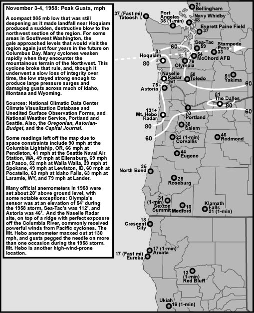
As I said before, this flooding situation was actually fairly different than the December 2007 floods. Those had very very very strong wind and had much worse impacts on the coast. A situation that closely parallels this were the November 2006 floods. Expect an in-depth analysis of this storm over the summer. In retrospect, the things that made this storm so destructive, especially for the Cascades, were the duration of time we got the heavy rain, the significant low-elevation snowmelt, the high freezing levels, the heaviness of the rain itself. The thing that really sets this storm apart though were the mid level (5,000 feet) winds. They weren't historically strong (unlike the December 2007 winds), but they were almost due west for most of the event. That's why the Seattle area got rain shadowed. However, these winds SLAMMED into the Cascades as the Cascades were perpendicular to the flow. This allowed for maximum oragraphic precipitation too occur. Again, I'll create a more extensive page on this sometime in the future, but the upper level winds put the word "historic" in this storm.

January 7, 2009
10:41 P.M.
What's golden people? I'll tell you what's golden. The Snoqualmie River will crest higher than it's ever crested before. And who called it? Charlie Phillips > lots of numerical and statistical models.
Alright that's nothing to get cocky about. Any person with any sense knew that the hydro models were underdoing their river estimates. This is just cool cause it makes me feel good about myself, which is always a good thing (unless it turns you into a dick :) ).
The heavy rain is still forecast to taper off around 2 A.M. Tomorrow, I will have a quick update on this storm, and perhaps somewhere down the road, I will post a more in-depth page about it. In the weather off-season (ie late spring, summer, early fall) I may not do these forecasts since I will be out of town but I will work on researching individual events (mainly windstorms) but also flood and snow events.
In the meanwhile, my cousins in Snoqualmie say they are getting flooded more than ever. I went to Snoqualmie Falls earlier last fall (2008) when there was major flooding on it. I looked at reports from KING5 and this event looks much more major.
This storm is much more similar to the November 2006 event than the December 2007 event. More on that later, it's getting late.
Remember: go see Snoqualmie Falls at all costs tomorrow. You will thank me sometime down the road. You will.

4:27 P.M.

This is beginning to look like the real deal folks. I just looked at the data for the Alpental ski resort as well, and they have gotten over 5 inches of rain in the last 15 hours. Several rivers are forecast to reach record severity flooding. The Snoqualmie River is expected to crest a couple inches below record stage. However, I think it will crest at record stage. We will have to see.
The rain shadow that has been keeping us dry while other places have been getting feet of rain has shifted to our north and weekend. This rain shadow, by the way, was extraordinarily strong. I thought there would be a little rain, but I thought there would be more than there was. There was no rain in Seattle this morning, while, to our west, east, north, and south, it was dumping. We are now seeing what everybody else has been seeing for the last 24 hours. It's not hard to realize why so many rivers are flooding when you take the rain we are getting now, make it heavier, and prolong it. That's what it's been like in the mountains. Freezing levels are at 7000 feet, so it is pretty much all rain in the mountains. This storm will be historic. KOMO says, "Heavy rains continue to fall across Western Washington as some areas could see flooding that we haven't seen in generations, if at all."
Still, while some rivers may be flooding at record severity, I got a question from Evan Shay about whether this storm is the same strength as the storm on December 1-3, 2007. It is not, and I can say that with confidence. Even though places in this storm may get even more rain, the December storm was shorter in duration as far as heavy rainfall is concerned and dropped more rain in a shorter amount of time. This biggest difference is wind. Wind is generally the best indicator of a storm's strength since the lower the pressure of a storm, the stronger the wind. Moisture doesn't have as direct of a connection to strength.
Bottom line on these two storms: The former was stronger, mainly because of wind, but this one will lead to flooding just like the other one. Because of upper level flow differences, the Olympics were favored more in 2007. Now, the Olympics and Cascades are favored. The Cascades have seen much more rainfall already than they did in 2007.
The steady rain is forecast to end around 2 AM in Seattle. Still, strong orographic flow will keep precipitation going in the mountains, although it will begin to wind down as well. Check out those links I posted in yesterday's post. AND GO TO SNOQUALMIE FALLS. YOU MAY NEVER SEE IT THIS HIGH AGAIN. I'VE GONE THERE IN SITUATIONS MUCH WEAKER THAN THIS AND IT WAS AMAZING. I doubt your parents will answer your pleas if you really want to go, but trust me... this is the highest I think that river will be for a long time.
Oh yeah, and we dry out tomorrow and keep dry for a week or so. Not much to talk about there... especially when the weather is like it is now.
Have fun in the rain!

January 6, 2009
9:48 P.M.
Woohoo!
Want to know what the NWS says on the situation?
THE OVERALL TREND IS NOT LOOKING GOOD WITH SOME VERY HIGH RAINFALL RATES STARTING TO COME IN THE PAST FEW HOURS
Yeah! That's what I'm talking about!
Precipitation rates look even higher. Isolated amounts of 30, yes, 30 inches are possible in spots. Widespread amounts of 10-15 inches are certain. Avalanche danger is extreme. Rain was falling at the rate of an inch per hour north and east of us. Again, the rain here isn't that bad as of now. There has already been over 5 inches in the past several hours in some spots on the Cascades and Olympics. If you live in a floodplain, move valuables to higher ground. AND SEE SNOQUALMIE FALLS IF YOU CAN. I GET THE FEELING THAT THE SNOQUALMIE RIVER COULD CREST AT AN ALL TIME FLOOD STAGE, EVEN THOUGH THE HYDRO MODELS DON'T AGREE. IT ALL DEPENDS ON HOW LONG THIS RAIN LASTS.
Stay dry under the Olympic rain shadow!

4:59 P.M.

Even if it's not raining at your house right now, it is raining very hard elsewhere. The Seattle metropolitan area is getting shadowed by the Olympics right now. Take a look at the radar, and you can clearly see a lot of rain in other parts of Western Washington. http://www.komonews.com/weather/radar
This shadow, however, will shift further north as time goes on. Therefore, Seattle will eventually get all the heavy rain everybody else is getting. The NWS is expecting 4 inches of rain in Seattle. I think we will see totals closer to 2-3 inches in Seattle proper, but places like Sea-Tac, which are currently not affected by the rain shadow, could see total rainfall amounts close to 5 inches. The Cascades and SW Olympics could see 15-20 inches of rainfall. That is a phenomenal amount of rain, and with all that rain comes flooding. I can say confidently that we will see moderate to major flooding on all area rivers, maybe even a few records. I highly encourage everybody to check out Snoqualmie Falls if they have time. It will be dramatic.
In the meanwhile, we have a little wind in the Seattle area. A wind advisory is in effect for most of Western Washington. We could see wind gusts to 45 mph, which is enough to cause some localized and isolated power outages. The main story over the next few days will be the rain and associated flooding. Here is a great website to see the stages of the rivers and their predicted heights.
http://ahps2.wrh.noaa.gov/ahps2/index.php?wfo=sew
Click on the names of places to see the forecast for the river and more specific information on it.
Remember: If you are up for an adventure and your parents are too, head to Snoqualmie Falls. It is forecast to reach major flooding at this point and may go even approach record stage.
And there is no snow for Seattle in the foreseeable future :)

January 5, 2009
5:20 P.M.

So actually, I just looked at the models and all guidance points to a major flood event for Western Washington. Our most dependable model for the region, the 4 km mm5-gfs, shows a constant, heavy rainfall from 1 A.M. Tuesday morning to 10 A.M. Thursday morning. A rain shadow will protect Seattle from excessive rainfall at first as the flow is westerly, but the shadow will shift north as the upper level flow gets more of a southerly component. models now show rainfall totals as high as 20 inches in the Cascades. Many tv stations are calling for urban flooding, but I don't think it will be that bad due to the rain shadow. We could see some urban flooding when the rain shadow moves north closer to Everett. Bottom line: even if it's not raining here, it's raining elsewhere. HARD. I suggest you go to see Snoqualmie Falls if you can get a ride. It is unbelievable when the river is at major flood stage.

4:54 P.M.

See snow totals HERE: http://www.facebook.com/group.php?gid=33875355514&v=app_2373072738#!/topic.php?uid=33875355514&topic=6006
Let's start out with a review of last night's storm. I actually thought I did a great job of forecasting it. The snow switched to rain at around 11 at my house, but switched later at other places (Mr. Stever, my marine biology teacher, said it turned to rain at 3 A.M. in Shoreline).
Just to get a couple things straight, I did NOT say there was a 10/100 chance of snow. I was fairly certain that there was going snow, and predicted a couple inches in my forecast. I was 10% sure that there was going to be a snow DAY, as I thought the rain would turn the snow into slush.
Things I learned from this: Fringe snow forecasting is really hard. I already knew that, but this just reinforced it. With the temperatures the way they were, a quarter of the time you would see snow, half the time you would see a rain/snow mix, and a quarter of the time you would see rain (that's at least what I think). We got more snow than I expected, and I'm afraid there's not really much I can learn from that. It wasn't a forecasting error or anything. It's just the nature of snow around here. You really have to see the snow falling before you can really put down some hard forecasts in these fringe situations, which is often too late.
I will confess, however, that I was fairly certain that we would have a late start. This wasn't a forecasting error though. I tried to predict SPS, who I've learned is very hard to predict. I thought they would delay because of all the slush on the road. I think they got impatient with all the snow days and just wanted kids to go to school. Even if I can predict weather, predicting the inner thoughts of school officials is even harder.
So... I thought I did well in this situation, but not much better than any other guys. This wasn't really a typical forecasting scenario. It was a "look out the window and see what's happening scenario." Anybody could have predicted this if they knew some basic signs to look for.
This week looks WET. We could see some flooding on area rivers, and after that, we could see a perhaps fairly extended (5-7 days) period of dry weather (which everybody loves except me). I'll right more on it later tonight after the UW models come out. They are one of my best resources.

January 4, 2009
6:59 P.M.

So... it's actually kinda snowing! Awesome for some, problemsome for others. I am looking outside right now, and frankly, I did not expect to see this much of snow (I have about a 1/2 inch outside my house right now). Neither did the NWS. They have issued a SNOW ADVISORY until 9 P.M. for all of Western Washington for 1-3 inches of snow. However, I think that it MAY keep snowing beyond that point. Here's why...
1.) snow acts to keep temperatures cool, and the atmosphere has cooled off from the snow.
2.) the precipitation is fairly intense due to some weak low-level convergence over Seattle and especially Bremerton. When precipitation rates are higher, it brings cooler air down to the surface and gives the snow less time to melt
3.) Cause Chris Swanson controls the weather and he says we are going to have a snow day
This is what you call a fringe snow event. Temperatures are RIGHT on the fringe. The temperature at my house is 34 degrees. Thankfully, dew points are low enough and precipitation rates are intense enough that the precipitation is remaining as snow.
All the other forecasters and the models are in agreement that the snow will change to rain at 9-midnight. I'm starting to head for the later part of that range. I've seen some helpful signs that we could see more snow. The snowflakes are getting smaller (which means the snow is drier, although it is still very wet) and snow is sticking. This is a very tough forecast and I'm listening to every single clue I can get to make a decision.
Models operate my pure mathematical equations. There is some weather wisdom you can incorporate into your forecasts in these times. For example, snow helps to keep temperatures steady. Models say rain tomorrow morning at Snoqualmie Pass. I don't think so. The storm coming in isn't all that warm.
Another good indicator more snow is that southerly winds have died down. We have less of a warming wind to eat away the snow and change the precipitation to rain.
Bottom line... this is a very difficult forecast. But I think that it will continue snowing for a couple hours, and then the precipitation will change over to rain. The best resources at this time are just temperatures and observations from other places. I am hoping for a snow day, but that looks unlikely. However, I have bumped my odds from 1 in 100 to 10 in 100. A 2 hour late start seems much more likely.
Feel free to ask me any questions, but just write them on the wall here. I will answer them. All the chat spazzes out my computer. Your best resource at this time is simply doppler radar and your temperature gage.
ONE MORE SNOW DAY!


12:28 P.M.

Looking at the models this morning, it looks as though there is a slight possibility that the Seattle area may see a little bit of light snow. The most advanced model we have (the 4km mm5-gfs) shows 2 inches of snow in the Seattle metropolitan area tonight as moisture from the Pacific comes streaming in over a marginally cool airmass. The latest satellite observations show that the storm may be slowing up, which does not bode well for snow, but still we could see a slushy inch or two. Later tonight, it will all change to rain. I guess there is a slight possibility that we could have a 2 hour late start tomorrow, but that looks unlikeley. The snow will probably melt and probably not really stick to the roads anyway.
Hood Canal could now see as much as 8 inches in isolated spots, the easterly outflow of cold air dams up against the Olympics there. This does two things: it increases precipitation (because of orographic enhancement) and it cools temperatures (because the air there is cooler). Hood Canal also has a bit of elevation in spots, which helps to keep snow there.
The mountains will see snow regardless. 1-3 feet is still on track for totals from this incoming storm.
Of greater interest is the middle of the week. Models show a very wet and mild pattern with very heavy rain in Western Washington. Seattle may get shadowed by the Olympics, but the mountains will see very heavy rain, and very heavy snow above 6-7000 feet. The models show over 60 inches of snow in a 24 hour period in those spots. Unfortunately, it looks like it will rain in the passes. The rivers look like they are going to flood and there could be some avalanche danger. Stay tuned.

January 3, 2009
Happy New Year Everyone!

I hope everybody had a fantastic New Year, and I hope it will be filled with excitement, love, and other goodies. Out with the old and in with the new! Woohoo!

First, before I explain the forecast, I want to go over a concept that isn't particularly advanced but is rather unknown to much of the greater Seattle area. What if I told you that the snow we get isn't always snow?
Everybody knows what snow looks like... it's white, it's fluffy, and it sticks to trees. Still, not all white things that fall from the sky are snow.
Today was a good example of a time when there was white stuff falling from the sky that wasn't really snow. If fell in pellets, and bounced high when it hit the ground. It isn't hail either though. It's graupel!
Graupel are kinda like snow pellets. They lack the hexagonal structure of a snowflake, but they are not hail either. Many people say we are getting hailed on when they see graupel. I don't know why they don't teach this in the schools. It's one of the biggest weather misconceptions I've noticed.
These pellets are not hail because hail is formed of ice, whereas graupel are still snowy and squishy. Hail are also generally clear, and graupel are white.You can have white hail, but you can NEVER have clear graupel.
To find out if it's hail or graupel, just pick up the sphere and squish it. If it's squishy, it's graupel. If it's ice, it's hail.
Hail is formed inside of a cloud when supercooled (liquid below 32 degrees) water droplets attach to each other and ice over. I'm not sure how graupel is produced, but it's not that way.
I've noticed that graupel usually occurs on cool days a really unstable atmosphere, or in a REALLY intense convergence zone. So for now on, when you see these snow pellets, I want your status to be "It's graupeling outside!"

Alright. The forecast looks fairly interesting, especially for midweek. We will get a strong warm front off the Pacific tomorrow and Monday that will provide breezy conditions, some rain, and gobs of snow in the mountains. The lowlands by Hood Canal may even see 2-4 inches of snow when the precipitation starts, as the airmass we have now is marginally cool enough for snow. The Cascades will see 1-3 FEET, which is great news for ski resorts. Still, the avalanche danger will be extremely high, so this is not a good time to be in the backcountry. I-90 may also close for avalanche control.
Tuesday-Thursday is where it gets interesting. A Pinapple Express will move through the area, blasting snow levels up to 7000 feet. This one looks fairly strong, and it will stall over our area, bringing very heavy rain to the mountains and extremely (several feet per day) heavy snow above that level. With rain in the mountains comes the threat of river flooding. Those who live in floodplains should be warned that a moderate to possibly major flood event is possible the middle of next week.


Hey so I just did some more research on graupel... supercooled water droplets actually are involved. Instead of supercooled water droplets sticking to each other and making compact ice, graupel is a coating of ice formed from supercooled water droplets around a snowflake. It is formed in convective atmospheres (ones with a lot of instability... like the ones we get with convergence zones and strong showers). All these graupel falling also produce a lot of static electricity in the air, which explains why I almost got struck my lightning razor clamming on the coast last year (it was graupeling at the time).