12:28 P.M.
 |
| Mr. Krupp on the left, and his alter-ego Captain Underpants on the right. Retrieved from the Captain Underpants Wikia Page. |
I don't know how many of you read the Captain Underpants books, but I grew up with them. They were based on the premise of Mr. Krupp, an extraordinarily mean elementary school principal, turning into Captain Underpants at the snap of a finger - a superhero with superhuman strength, the ability to fly, and even 100% cotton-power vision - , and then turning back into his mean self when a bucket of water is dumped on his head.
I think that's a beautiful simile for the weather we have seen lately. However, it may have actually had some truth for me. At the first clap of thunder, I turned into an other-worldly human - one that didn't need sleep, one that was capable of withstanding extremely long periods without blinking, and of course, one that was capable of predicting the frequency of lightning strikes associated with one storm (with a little help from the radar, but don't tell anybody).
At that first clap of thunder, millions of individuals became their own Captain Underpants.' They valiantly fought fires and drove hundreds of miles to see the largest storms in the Pacific Northwest. They stood outside and weathered the elements of wind, rain, and even golfball-sized hail, just to get a glimpse of the incredible lightning show we experienced. Some people went to great lengths to document the storms that will surely sweep the 2014 Academy Awards. And as soon as the weather returned to normal, people became their mechanical, grumpy selves just in time to work their 9-5's for the rest of the week.
We had an unusual pattern that produced all these storms for us, which I will explain in detail in a later blog. Let's take a look at what's happening now.
 |
| Valid 05:00 am PDT, Tue 13 Aug 2013: UW 8/13/13 12z WRF-GFS: 500mb Absolute Vorticity, Heights |
I wouldn't say that this is our typical summer pattern - usually, the ridge of high pressure that is currently well south of the Aleutians is further eastward, shoving the jet stream northward into Alaska, but it's close enough. As you can see, we've got a trough offshore, and this will get slightly closer and then stall off our coast, bringing some weak rain showers (no lightning, sorry) and cooler temperatures to our region.
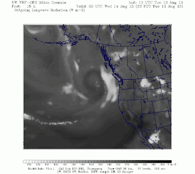
For the immediate future, we will actually see highs above normal because this trough is generating some downslope flow off the Cascades, thus giving us clear skies and warm temperatures. Wednesday will feature increasing clouds as the trough comes closer to our coast. The model below shows the amount of infrared radiation (heat) emitted from Earth and atmospheric clouds into space and is analogous to a picture one would obtain from an infrared satellite.
 |
| Valid 11:00 pm PDT, Tue 13 Aug 2013 - 18hr Fcst: UW 8/13/13 12z WRF-GFS: Outgoing Longwave Radiation |
According to this morning's WRF-GFS run, Seattle looks to pick up a whopping tenth of an inch of rain from this entire storm. The Olympics and central Cascades northward will see higher amounts, but even they are only predicted to pick up a half-inch of rain from this storm. Long story short - it won't be a washout.
 |
| Valid 05:00 pm PDT, Fri 16 Aug 2013 - 84hr Fcst: UW 8/13/13 UW 12z WRF-GFS: 4km 72-Hour Precipitation |
After this "storm" rolls through, we'll enter a pattern we are quite familiar with... morning clouds followed by afternoon sun. See my previous blog below for an explanation of these events.
I hope you can make the best of a return to normal weather. But please, do us a favor and keep those trowsers on.
All the best,
Charlie
No comments:
Post a Comment