Wednesday, October 26, 2011

Mt. Rainier Weather

Wednesday, October 26, 2011
12:23 P.M.


Mt. Rainier is one of the most prominent peaks in the world, and it is certainly the most prominent one in the contiguous United States. Because it is so prominent, it can influence clouds, rainfall, snowfall, and even sunlight for miles.

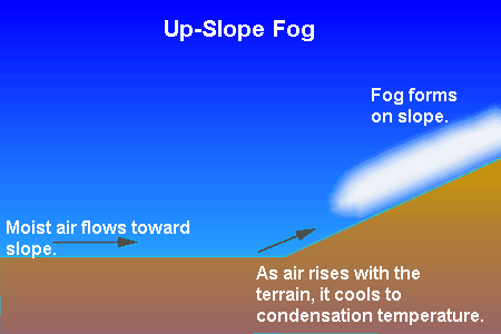
Mt. Rainier gets some especially interesting cloud formations. Take a look at the picture below.  

Photo credit: Tim Thompson - December 2008

Don't worry, this is not an alien invasion. Here, we see several lenticular clouds!

Lenticular clouds are fascinating meteorological phenomena that occur when moist air flows against terrain and condenses into water droplets. Mt. Rainier is a huge obstacle to air, so it often creates these clouds if the air is moist and there is sufficient upslope flow. These clouds are often precursors to rain, so if you see these clouds, be on the lookout for rain in the coming days!

Mt. Rainier is also the most heavily glaciated peak in the contiguous U.S., and gets tremendous amounts of snowfall. Paradise, on the windward side of Mt. Rainier, can get particularly snowy. It averages over 53 feet of snow each year, and some years, the average snowfall reaches over 90 feet! Check out the historical snowfall data for Paradise below.


Of course, it snows when it is cold outside, but when it rains on Mt. Rainier, it pours. Mt. Rainier was particularly hard hit in November of 2006, when places of the national park surrounding the mountain received 18 inches of rain in 36 hours. Here are some photos below. These are all taken from the National Park Service.


Pretty incredible stuff!

But the main reason I decided to write this blog post today was because I saw some pictures of an amazing shadow Mt. Rainier cast during sunrise. We get these shadows during the autumn and winter when the sun is positioned directly behind the mountain for somewhere in Puget Sound. We don't get these shadows in our area in the summer because the sun is too far north to cast a shadow in the Puget Sound area.

From KOMO "YouNews" contributor "ddlippert"

From KOMO "YouNews" contributor Susan Aaron 

From KOMO "YouNews" contributor "JPuyallup"

The coolest part? All these photos were taken this morning.

Thanks for reading, and have a nice day!
Charlie

Tuesday, October 25, 2011

Different Types of Fog

Tuesday, October 25, 2011
2:52 P.M.


October is the foggiest time of year for the Puget Sound region, and we talked about fog today in my Atmospheric Sciences 101 class with Cliff Mass. I am still amazed by how many specific types of fog there are. We talked about radiation fog, advection fog, upslope fog, steam fog, and even frontal fog. We didn't talk about "screaming face fog," but I think that type of fog only exists in Hollywood. Fog can be pretty creepy at times though. Of course, sometimes it can be downright dangerous. I'll get to that later on.

Let's look at the different types of fog!

Here's the most common type of fog we see around here... radiation fog.


Photo credit: Liem Bahneman

To get radiation fog, you mainly need clear skies and cooling, moisture in the air (a wet ground really helps), and light winds. We tend to get all of these in October. In November-January, we get our really strong storms, and strong winds/cloudy nights prevent fog. As we transition into spring, we see longer days and generally do not have the large high pressure systems needed for fog formation... we get those showers and sunbreaks! Seattle gets little fog over the summer because of the relatively dry air and warm temperatures. In the fall, though, we get these storms that can leave the ground moist, and in between these storms, we have calm weather and clear nights. Thus, we get fog.

Most fog reaches a few hundred meters up, but sometimes radiation fog doesn't even hit above the knee. Fog has a harder time forming when winds are completely calm. If winds are calm, there is no mixing of the atmosphere and the saturated air at the immediate surface is stagnant, leaving a very thin layer of fog at the ground. This type of fog is called ground fog, and it is a specific type of radiation fog.

Photo from "bikecam"

Now... the second most common type of fog: advection fog!


Isn't that a beautiful shot? San Francisco gets this type of fog all the time. Advection fog forms when relatively warm, moist air moves over cool water. The water cools the air to the dewpoint, resulting in fog. Advection fog is common over the Pacific Coast in the summer. One of the reasons we get it is because of upwelling, which results in cold water near the ocean. Puget Sound can get advection fog too... I've been fishing in it!

Now, I shall explain upslope fog!


Mattole Beach, Humboldt County, California - photo credit: "stepleton"

Upslope fog forms when moist air rises up terrain and condenses into clouds. I was up at Mt. Rainier with some UW students this past summer and we encountered some upslope fog, which was actually really annoying because we couldn't see the mountain! I've also encountered upslope fog when skiing at Snoqualmie Pass, which is annoying because you can't tell the difference between the snow and the sky!

Next is steam fog! Steam fog is one of the most beautiful types of fog.


Pine Lake, Sammamish, Washington - Steve Ringman - The Seattle Times

Pine Lake, Sammamish, Washington - Steve Ringman - The Seattle Times

Steam fog forms when cold air moves over warm water... kind of like advection fog in reverse. We generally don't see a lot of steam fog, but we can see some in those super cold snaps during the winter. Steam fog is usually pretty shallow. Look for it on Lake Washington during the next arctic outbreak!

And finally... frontal/precipitation fog!


Frontal fog is generally associated with warm fronts and forms when precipitation falls into cold air and saturates it. I personally think frontal fog is pretty boring, but each to his own...

Fog can be dangerous because it limits visibility. I've been fishing in very dense advection fog and have had to pay close attention to not hit any boats or other obstacles. However, the most dangerous form of fog is freezing fog. Freezing fog is a type of fog where the water droplets are supercooled and freeze onto objects they come in contact with. These supercooled water droplets occur most often in radiation fog or upslope fog. I am not including freezing fog as its own category because it is simply a subtype of other forms of fog, but it is the one to watch out for. Roadway icing is the biggest weather killer in the Pacific Northwest, and freezing fog can very quickly glaze a thin layer of black ice over roadways. When temperatures drop below freezing and fog rolls in, be very careful when driving, and, if necessary, pull over and wait for the road to clear up. It could very well save your life.

One thing pointing out is that areas east of the Cascades get the most fog in the winter. Air is relatively moist, cool, and calm over there during the winter, leading to a higher frequency of fog there than during the summer.

Taken from Cliff Mass Weather Blog, "Fog Season," 10/16/10

This was a long post! My schedule next quarter will be pretty intense, so I won't have much time for these long posts. For now though, I enjoy writing them.

Thank you for reading!
Charlie

Long Term Cold Snap?

Monday, October 24, 2011
11:46 P.M.


The graphic above shows the temperatures and precipitation predicted each day out to 16 days in the future by the GFS (Global Forecast System) model. I recently installed several programs from http://www.brianschmit.com/ and this was one of them. I've talked to Brian and he has given me permission to use his programs and post the pictures. His website is incredible, I'd highly suggest checking it out. Additionally, you can go to the "Downloads" tab on the right and download some of his programs. They are very, very helpful and informative. Thank you so much Brian!

It is interesting to look at these long term forecasts, but they are generally only good for seeing trends, and sometimes they are too inconsistent to even see that. The NWS generally makes daily forecasts out to seven days, and uses the rest of the GFS model input to look for trends. Lately, the GFS has indicated very cool temperatures for the beginning of November along with several wet systems coming through. The precipitation has varied wildly from run to run, but the bottom line is this: we will likely see significant snowfall in the mountains starting the first week of November.


By the way, that above picture is from late January of 2008, when the pass was closed for super heavy snow. We won't be seeing any weather quite like that right yet, but the pass should get pretty snowy, and if this La Nina pans out as expected, we should have a pretty snowy winter in general.

Before we get cold, we will see highs in the mid 50s this week with periods of light rain starting Friday and continuing until at least Monday as a series of decaying fronts sweep through. Nothing to write home about. But after that? Hold on to your hats.

November is coming.

Thursday, October 20, 2011

Another La Nina Update

Thursday, October 20, 2011
12:38 P.M.


Normally, I would not update the La Nina situation, but I saw something startling today. I was looking over this "Pacific Northwest Weather" group on facebook (btw, you should join it!) and somebody posted this graphic. I looked into it and discovered that the model above is the latest CFS model from NOAA. It is forecastin a La Nina of epic proportions. Last year's La Nina peaked at a -2 Celsius SST anomaly in the region Nino 3.4, but this one is forecasting a -3 degree anomaly! Absolutely incredible. Right now, it is an outlier, but this is still very surprising to see because the CFS is usually one of the most accurate models for forecasting El Nino/La Nina events.

For your courtesy, a graphic of the specific El Nino/La Nina regions is given below.


I don't know if there ever has been a -3 degree anomaly in Nino 3.4, so that would be absolutely incredible. I seriously doubt that will happen. But one thing is for sure... this La Nina is trending to be more intense than previously forecast. Most models are trending slightly cooler, and as you have seen, the CFS is off the charts.

Here is an animation of the SST over the tropical Pacific over the last 2 1/2 months. You can see a weak-moderate La Nina thus far, and the CFS believes it will rapidly strengthen soon.


This is an awesome animation, and you can see the animation with additional material and data at the "Tropical Pacific SST" link on the right side of my blog.

As far as immediate weather goes, we will be cloudy today before seeing a series of weather systems over the weekend. None of these systems will be particularly strong, but they will some blustery conditions and varying amounts of rain, with more in the mountains and less around central Puget Sound due to rain-shadowing.

This picture shows one coming in at 11 A.M Friday.

Valid 11:00 am PDT Fri, 21 Oct 2011 - 30hr Fcst - UW 4km 12z WRF-GFS 3-hour precip


Then, we'll have a weak wave brush through our area around noon on Saturday.

Valid 11:00 am PDT Sat, 22 Oct 2011 - 54hr Fcst - UW 4km 12z WRF-GFS 3-hour precip

Finally, we'll see a weak cold front come through Saturday night/Sunday morning.

 Valid 02:00 am PDT Sun, 23 Oct 2011 - 69hr Fcst - UW 4km 12z WRF-GFS 3-hour precip


This next diagram shows the 48 hour precipitation for our area ending 5 A.M. PDT Sunday. Take a look at the large amounts of precipitation in the mountains and the lighter amounts by Seattle. The precipitation is being enhanced in the mountains from rising air, but as the air flows off of the Olympics, Seattle and places on the north Kitsap Peninsula will be shadowed. Of course, south-central Washington will be shadowed as well.

Valid 05:00 am PDT Sun, 23 Oct 2011 - 72hr Fcst - UW 4km 12z WRF-GFS 48-hour precip

The mountains, particularly the Olympics and North Cascades, are getting clobbered with rain, but you can see some pretty defined rain shadowing extending northwest from southern Lake Washington.

I have noticed that tv weather stations don't get into specifics about rain shadowing much, so don't be surprised if you turn out to have only a little bir of rain while some places in the Cascades pick up 5 inches from this storm. Ahh... the beauty of Pacific Northwest weather forecasting.

Have a good one you guys! Thank you for reading.
Charlie Phillips

Wednesday, October 19, 2011

Change is in the Air

Wednesday, October 19, 2011
5:41 P.M.


Yesterday, I wrote about the variability of autumn weather in the Pacific Northwest and how we can see big changes in short periods of time. Today, we didn't see a monumental change in the weather, but it definitely wasn't like yesterday. As I was walking back from the IMA at the University of Washington, there was a nice, refreshing breeze and plenty of leaves flying around. It wasn't super windy, but it was nice to feel some gusts ruffle my hair and send leaves in those small little whirlpools we often see in blustery conditions.


This diagram above shows the change in winds over the past 12 hours for different heights in the atmosphere as recorded by the Sandy Point profiler. The change is not quite as dramatic as yesterday, but you can still see a shift from northerly winds to southerly winds in the lowest levels of the atmosphere. You can also see a change in the winds in the upper atmosphere from southeasterly to south-southwesterly, which generally means that a low pressure system is progressing westward. We had a weak low pressure system give us some clouds today, but we will see stronger systems Friday through the weekend.

These systems will be directed to us via a zonal jet stream pointed right at us. Check out the graphic below... it shows the winds at the 300mb level forecast for 8 P.M. PDT Friday.

Valid 08:00 pm PDT Fri, 21 Oct 2011 - 63hr Fcst - UW 36km 12z WRF-GFS 300mb Isotachs

This jet stream is not going to move much, and it is going to direct a series of weak systems into our area. The mountains will get lots of rain because the winds aloft will be favorable for orographic enhancement. However, what goes up must come down, so while the mountains are getting enhanced rain due to upslope winds, northern Puget Sound will get a partial rainshadowing effect from downslope winds coming of the Olympics. And of course, if you want to be completely dry, go to south-central Washington.
Valid 05:00 am PDT Sun, 23 Oct 2011 - 96hr Fcst - UW 12km 12z WRF-GFS 48-hour precip

North Seattle will actually see very little rain from this system. The shadowing will be felt less in south Seattle, but it will still be significant at certain times. 

After Monday, the weather is actually looking quite pleasant as a strong ridge of high pressure sets up off our coast. You can see the ridge moving the jet stream northward in the diagram below.

Valid 11:00 pm PDT Tue, 25 Oct 2011 - 162hr Fcst - UW 36km 12z WRF-GFS 300mb Isotachs

You better enjoy this nice weather next week, because inevitably, we will get stormy when November rolls around.

Have a good one,
Charlie

Tuesday, October 18, 2011

Autumn in the Pacific Northwest

October 18, 2011
1:27 P.M.


Generally, the Pacific Northwest has gradual seasonal changes. Winter very gradually transitions into spring, and apart from a few thundershowers here and there, spring gradually shifts into summer. Summer also shifts gradually... from cool, cloudy days in June to nice sunny days in August. But there is one season in the Pacific Northwest that isn't quite so gradual to change, and this is autumn.

I was reading Scott Sistek's blog post about the warmth we would experience today, and he made an interesting point. The average high for September 18 is 70 degrees. The record high for October 18? 70 degrees. It's amazing what a difference a month can make.

A classic example of the variability of autumn weather was November of 2010. Take a look at the temperatures and weather recorded each day.


It's not too often that you see a high of 74 and a high of 25 spaced 20 days apart. And if you really want to see a crazy month for weather, look at November of 2006.


November 2006 had a lot of temperature variation, but it was very stormy. With an average windspeed of 11 mph and 15.63 inches of precipitation, November 2006 will go down in history as being one of the craziest weather months ever.

On October 12, 1962, the Columbus Day Storm pounded the Pacific Northwest. This storm was the earliest major windstorm to ever strike the Pacific Northwest, and it was the most powerful extratropical cyclone to ever hit the Pacific Northwest in terms of wind speed. I'll go ahead and show you a diagram of the peak gusts from this storm, just because it is amazing to look at.

From Wolf Read's personal website, "The Storm King"

Why is the weather in the autumn so variable around here? It all has to do with temperature differences between the polar regions up north and the tropical regions down south. As the earth receives less sunlight, both the air and water cool off. However, different parts of the earth receive different amounts of sunlight. The equatorial areas are receiving lots of sun right now since we are only a month after the summer solstice, and the north pole is shrouded in continuous night until spring. As a result, the water near the tropics is still very hot, but the polar regions, which have more land and lose heat more quickly, are becoming very cold very quickly.

Mid-latitude cyclones feed off of these differences in temperature, and these are most pronounced during autumn. Additionally, tropical moisture often gets entrained in the westerlies this time of year, providing vast quantities of energy for cyclone formation. The Columbus Day Storm actually started off as Typhoon Freda in the Pacific.

The spring transition is much more gradual because the polar regions, which are cold, heat up relatively quickly compared to the tropical regions. Since there aren't as many changes in temperature throughout the latitudes, there aren't as many powerful extratropical storms for us. Spring is generally dominated by severe thunderstorms and tornadoes because the temperature changes rapidly with height as opposed to latitude. With a high sun angle and an unstable atmosphere, severe storms can flourish. Since the Pacific Northwest generally does not get severe thunderstorms, springs are a pretty gradual transition for us. Take a look at the temperatures recorded at Sea-Tac this past April.


As you can see, these are pretty gradual changes. No big storms, no heat waves, no cold spells. The sun is at a much higher angle over our area in April than it is in November, yet last November saw a 74 degree high, while the warmest day for April was 66 degrees. The coldest high for April was 46 degrees, and the coldest high for November was 25 degrees.

It is very interesting to watch how quickly the weather changes around here in the fall, and I'm hoping for some wild weather swings in the next month or so.

Thanks for reading!
Charlie

Monday, October 17, 2011

Tomorrow Will be the Warmest Day for Several Months

Tuesday, October 17, 2011
4:04 P.M.


That was a bold title, and I may end up eating my own words at some point in the next couple weeks. Nevertheless, I firmly believe that tomorrow will be the warmest day until spring of next year.

One commonly associates low pressure with cloudy, rainy, and sometimes downright stormy conditions. Tomorrow, however, low pressure will be our friend.

Winds in the atmosphere are the result of pressure differences in the atmosphere. Wind generally flows from high pressure to low pressure.Tomorrow, we will have a weak trough off of our coast and higher pressure in Eastern Washington, so we will see an offshore wind (easterly) wind. This type of wind generally gives us relatively warm and dry conditions, and if a big offshore wind event sets up in the summer, Western Washington can see some serious heat.

If you look at the "Chinook Wind" diagram, you can see some text that reads "adiabatic warming." Believe it or not, everybody has experienced some sort of adiabatic effect in their life. Adiabatic cooling refers to the cooling and expansion of air as it rises, and adiabatic warming refers to the warming and condensing of air as it sinks. Adiabatic cooling is visible as clouds, so you have certainly experienced adiabatic cooling. Adiabatic warming is associated with clear skies, warm temperatures, and dry air, and it is how we get our heat waves in the summer.

On the windward side of the Cascades, air rises, but on the leeward side, it sinks. When we have low pressure to our west, we are on the leeward side of the Cascades because the air coming in to "fill" the low pressure originates from our east. Tomorrow, we will be on the leeward side, and the air coming over the Cascades will sink and warm when it gets to Puget Sound. Hence, we will experience our last "warm wave" for a long time!

Let's take a look at the models for tomorrow.

Valid 11:00 am PDT Tue, 18 Oct 2011 - 30hr Fcst - UW 12km 12z WRF-GFS Sea-Level Pressure, 10m winds, 925mb temp

Take a look at the pressure difference over the Cascades. Higher pressure in Eastern Washington and lower pressure over us.

The next graphic shows the 10 meter wind speed at the same time. This is with the 4/3 km resolution model. You can really see some details in this one.

Valid 11:00 am PDT Tue, 18 Oct 2011 - 30hr Fcst - UW 4/3km 12z WRF-GFS 10m wind speed

You can see fairly strong offshore winds around the foothills, with the strongest ones near Enumclaw. Enumclaw often gets very windy during offshore flow events. On Christmas Eve of 1984, they saw winds over 100 from an offshore wind event. I'll talk about Enumclaw windstorms in a future blog post.
My favorite graphics for tomorrow are below. These show the temperature forecast at various points throughout the day.


8 A.M.

Valid 08:00 am PDT Tue, 18 Oct 2011 - 27hr Fcst - UW 4/3km 12z WRF-GFS 2m temp

11 A.M.

Valid 11:00 am PDT Tue, 18 Oct 2011 - 30hr Fcst - UW 4/3km 12z WRF-GFS 2m temp

2 P.M.
Valid 02:00 pm PDT Tue, 18 Oct 2011 - 33hr Fcst - UW 4/3km 12z WRF-GFS 2m temp

You can see the interior getting really hot. One thing I really want to point out is how warm the foothills on the western sides of the Cascades and Olympics are. You can definitely see this in the 8AM and 11AM  frames. The foothills get a stronger adiabatic warming effect than places by the sound or off of the coast, explaining the warmer temperatures. 

Bottom line: enjoy tomorrow! 
Charlie

Sunday, October 16, 2011

The Vostok, Antarctica Ice Cores

Sunday, October 16, 2011
1:21 P.M.


At first glance, Vostok, Antarctica, seems like one of the worst places on the planet to set up a permanent settlement. In many aspects, it is. It is the coldest place on Earth. It is the most isolated research station in Antarctica. It experiences a polar night of 130 days, with 80 days in pitch-black darkness. The air is ionized, it can get really windy, there is very little moisture in the air, and, being at 11,444 feet, getting sufficient Oxygen is a problem as well.

Not surprisingly, the few research scientists that live here have a tough life. While they are acclimatizing, they will experience headaches, earaches, nose bleeds, high blood pressure, vomiting, arthritis, joint/muscle pain, insomnia, perceived suffocation, reduced appetite, and weight loss ranging anywhere from 7-26 pounds.

Why would anybody want to create a settlement in this godforsaken land?

Vostok serves a few purposes, such as studying the magnetosphere and seeing how much ibuprofen it takes to stop a headache, but chief among these purposes is the studying of ice cores. The reason why Vostok is at such a high elevation is not because it is situated on high terrain; it is because there are thousands of meters of ice below it. In 1996, scientists drilled up an ice core 3623 meters deep before stopping, fearing they might contaminate a pristine underground lake below all of this ice. Scientists used the first 3345 meters of ice to study the changes in atmospheric composition for the past 436,000 years, and found some interesting results.


The first blue graph shows Carbon Dioxide concentrations, the red graph shows average temperature, the light green graph shows Methane Concentrations, and the light orange graphs show the relationship between O18, an isotope of Oxygen, and solar radiation. Looking at the graph, it seems like the most O18 appears when solar radiation is the highest. CO2 (Carbon Dioxide) and CH4 (Methane) are both greenhouse gasses, and you can see a strong correlation between them and the average temperature of the Earth.

Below is a graph of current CO2 concentrations, taken from the top of Mauna Loa, Hawaii.
The highest CO2 concentrations shown over the past 436,000 years are around 280-300 ppm. For September 2011, CO2 concentrations at Mauna Loa were 389 ppm. Vostok does not take current CO2 measurements.

Also, take a look at the CH4 concentrations from Mauna Loa.

Historical Methane values at Vostok reached slightly over 700 ppb at their peak, and now, they are 1800 ppb. Mauna Loa is a volcano, but scientists state that no measurable methane amounts come from the summit area.

Vostok, the little research station that could, has given us invaluable but alarming information. Sharp increases in temperature are correlated with sharp increases in greenhouse gasses. With CO2 and CH4 at all time highs, significant warming will occur. We are still figuring out the exact implications for specific areas, but as a whole, the earth is going to warm.

I hope to take an oceanography class centered around climatic extremes next quarter at the UW, and I'm sure I'll be learning a whole lot more about climate trends.

Thanks for reading! I have to get back to some research I'm actually assigned to do...
Charlie