Monday June 20, 2011
12:49 P.M.
I just took a look at the GFS "Superensemble" model, which goes 16 days out. Although it is pretty much useless for actual forecasts 16 days out, it can show trends. Often times, the trends change every time, so there is no point in paying attention to the model. Lately, however, they have all been pointing to a continued onshore flow pattern, meaning we will see light showers and clouds into July. Sorry guys.
Other than that there isn't much going on in the weather department, maybe I'll do another blog post later today about some interesting weather around the world.
Peace,
Charlie
Monday, June 20, 2011
Sunday, June 19, 2011
Sunny, then Wet
Sunday, June 19, 2011
6:18 P.M.
Yesterday was very cold and wet. Highs didn't reach 60 in many places, and Seattle got close to a half inch of rain. That would be a pretty wet day for winter, and although it would be very mild as well, there have been warmer days in December and January. Still, that's pretty cold, seeing as we are only a few days away from the summer solstice.
I have some good news and bad news. The good news is that we will return to a partly cloudy pattern with highs in the 70s next week. The bad news is that this will end on Thursday. Remember how I was showing that trough of low pressure with the corresponding low heights just offshore in my last blog post? Well, new forecasts show that this trough will move further onshore, giving us showers, clouds, and cool weather. Bummer.

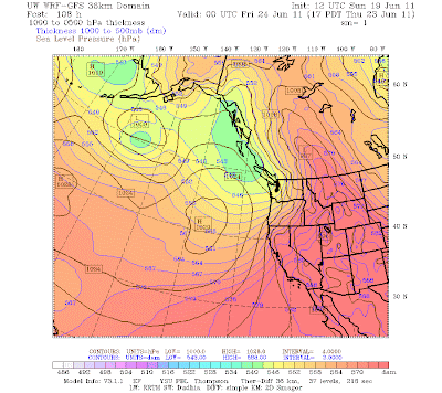
UW 12z WRF-GFS 1000-500mb thickness at 5 P.M. Thursday, June 23

3-hour precipitation, same model, same time
Bottom line: Monday-Wednesday - good days to get outside. Thursday onwards will be cool with periods of light rain from time to time.
Thanks,
Charlie
Friday, June 17, 2011
Another Beautiful Day in the Neighborhood
Friday, June 17, 2011
1:08 P.M.
I am loving this weather right now! Sure, it could be a little warmer, but it is nice and sunny outside, and that is definitely good enough to put me in a good mood. Just like the past few mornings, we had some morning clouds, but they were significantly weaker this time around, and much of the low ones burned off at around 10 A.M.
I am personally hoping we get some massive heat waves to warm up the lake so that I can go swimming in it. Unfortunately, that doesn't look very likely right now. We will have a small disturbance come in over the weekend, bringing some cooler air along with it. The 1000-500mb thickness diagram below for Saturday at 5 P.M. shows the cooler air over our region brought in by a weak system of low pressure. This is from the extended 12z WRF-GFS run from the UW models.

You can also see cooler air over the Aleutians and warmer air in the desert southwest. Thankfully, we are not expected to see this cold air drop into the Pacific Northwest. However, we will see some of the fringe effects of it next week, as this 8 P.M. Wednesday forecast from the same model shows.

You can see a fairly sharp increase in thickness as you head further onshore. However, with that big ridge of high pressure at 140W, we will see an onshore flow, which means we should have morning clouds followed by afternoon sun.
Have a good day everybody! Enjoy the sun.
Charlie
Thursday, June 16, 2011
Trending Warmer
Thursday, June 16, 2011
4:55 P.M.
Greetings everybody, now that I am graduated from high school I can continue writing on this blog more regularly. It may seem like we have been really cool and cloudy lately, but this is actually pretty typical June weather. The last few days have only been slightly cooler than average, and we are slightly below average for precipitation this month. It is typical to see fairly heavy "marine layers" of clouds formed by onshore flow in the morning in June, and that is what we have seen this month. Instead of having a blocking ridge of high pressure like we do later in the summer, the jet stream is generally pointed somewhere in our direction in June, and even though it is much weaker than it is in the winter, it still is strong enough to direct cool maritime air into our area. The image below shows the winds at the 300 millibar level of the atmosphere, which is where the jet stream is located. You can see how the jet stream comes into our area from the NNW, giving us cool air and clouds.

However, much of this will change soon, and we will warm up. We saw our morning clouds today part at around noon, and this is something we will continue to see for the next few days. Unfortunately, a disturbance will come in over the weekend and we will see some rain, but we will warm up into the mid 70s next week, which will be nice. In addition, the newest model runs indicate that this system will be weaker than previously thought.
I like cool and wet (or snowy) weather in the winter, and hot and dry weather in the summer. We had a good winter, and hopefully we can have a good summer too!
Thanks for reading!
Charlie
4:55 P.M.
Greetings everybody, now that I am graduated from high school I can continue writing on this blog more regularly. It may seem like we have been really cool and cloudy lately, but this is actually pretty typical June weather. The last few days have only been slightly cooler than average, and we are slightly below average for precipitation this month. It is typical to see fairly heavy "marine layers" of clouds formed by onshore flow in the morning in June, and that is what we have seen this month. Instead of having a blocking ridge of high pressure like we do later in the summer, the jet stream is generally pointed somewhere in our direction in June, and even though it is much weaker than it is in the winter, it still is strong enough to direct cool maritime air into our area. The image below shows the winds at the 300 millibar level of the atmosphere, which is where the jet stream is located. You can see how the jet stream comes into our area from the NNW, giving us cool air and clouds.

(UW model: 12z GFS)
I like cool and wet (or snowy) weather in the winter, and hot and dry weather in the summer. We had a good winter, and hopefully we can have a good summer too!
Thanks for reading!
Charlie
Thursday, June 2, 2011
Warmer this weekend!
June 2, 2011
3:08 P.M.
Hello everybody, I'm at the Garfield Community Center right now and for some odd reason I can't post pictures to my blog at this time. Anyways, I have some good news! Next weekend will be our warmest weekend since September! Don't get too excited, we aren't getting into the 90s. However, we will warm up to approximately 75 on Saturday and possibly even higher on Sunday. I would not be surpised if Seattle hit 80 on Sunday, although it seems like the National Weather Service and the tv stations are calling for mid to upper 70s with a few isolated 80s near the water.
Why are we all the sudden getting so warm when we have been so cold lately? It all depends on which direction the wind flowing into our area is coming from. For nearly all of this spring, we have had an onshore flow, which means that air is flowing "onshore" into our area from the Pacific. This type of weather generally gives us cool temperatures with scattered showers. The offshore flow typically ramps up at night, because as the land warms during the day, it decreases in pressure, and air rushes in off the Pacific to fill the discrepancy in air pressure later in the day through the night. We have seen lots of stratus clouds in our area in the morning, and these are a result of the "marine push" from the ocean. Because of their maritime origins, stratus and other low-lying stratiform clouds are known as the "marine layer" by local meteorologists.
This weekend though, we will have an offshore flow, which will warm us up significantly. When air is coming off the Cascades, it has continental origins (warmer at this time of year) and it also warms up as it descends. We get this offshore flow when we have lower pressure off the coast and higher pressure inland, since air always flows from low to high pressure.
We will get very warm on Saturday, but why don't we immediately get a marine push on Sunday? The reason is that the flow will stay offshore. Although the land will have lower pressure because it has warmed up, the pressure over the ocean will still be lower, due to the pressure gradient from a ridge of high pressure over the area, a weak area of low pressure off the coast, or a combination of the two.
However, all good things must come to an end, and we will get a marine push Sunday night into Monday just in time for the last few remaining days of school for us seniors. This is because the flow will turn onshore, with higher pressure over the water and lower pressure over land. This marine push is a very common occurence during the summer, and it is the principal reason why we don't need air conditioning in the Pacific Northwest (although it would have been nice a few years ago when Sea-Tac got up to 103). Open your windows Sunday night and see how the house feels Monday morning.
Thanks for reading! Off to a gig...
Charlie
Subscribe to:
Posts (Atom)