3:49 P.M.
Good afternoon everybody! Hopefully most of you experienced that absolutely incredible lightning show last night. Thankfully, if you missed it, we've got another one stepping up to the plate.
First off, let's look at the radar.

Thunderstorms are currently firing up across the area, with some particularly strong ones slightly east of Mt. Rainier, due east of Salem in the Cascades, and slightly west of Baker City, Oregon. I can see the wispy tops of the cell by Mt. Rainer extending northwestward just shy of my Seattle home. The area of heaviest precipitation may be small, but all these storms are massive in size. The precipitation shows up more clearly on the two cells in Oregon. There are light green echos surrounding a red dot in the middle. This red dot indicates the heaviest precipitation, and the light green indicates lighter precipitation that is likely falling from a higher elevation under the anvil of the storm. In this picture, the Mt. Rainier cell does not seem to have these green echoes, but in the minutes since I've taken this screenshot, I have seen these green echoes forming around it.
How well did the models forecast these storms? Honestly, I think they underdid it.
 |
| Valid 05:00 pm PDT, Sat 10 Aug 2013 - 12hr Fcst: UW 8/10/13 WRF-GFS: 4km 1-hour Precipitation |
Take a look at the model above. You can make out those three individual cells, but they are all weaker than what is currently being shown on the radar, particularly the Mt. Rainier cell. They also do not have any lighter rain surrounding the cells, but I expect that this may be due to the models taking the evaporative affect of dry air on rain into account so that no rain hits the surface. Salem is indeed dry right now with a relative humidity of 23%, so the rain being captured by the radar is evaporating before it hits the surface.
Here's what the National Weather Service office in Seattle had to say in their 4 P.M. AFD (Area Forecast Discussion)
EXPECT
  ANOTHER ROUND OF THUNDERSTORMS TODAY...ESPECIALLY THIS AFTERNOON AND
  EVENING AS THE LOW CONTINUES ITS SLOW PROGRESSION NORTH ADDING UPPER
  LEVEL SUPPORT TO THE MOIST AND UNSTABLE CONDITIONS ALREADY IN PLACE.
EXPECT THIS TREND TO CONTINUE THROUGH THE EVENING AS SCATTERED
  THUNDERSTORMS CONTINUE TO DEVELOP OVER WESTERN WASHINGTON. THESE
  STORMS MAY PRODUCE SMALL HAIL AND WIND GUSTS TO NEAR 40 MPH.
But according to the 12z WRF-GFS this morning, we won't just see thunderstorms in the afternoon and evening. Just like last night, a shortwave trough is expected to roll through and bring some additional storms to the area. This trough will likely be an hour or two ahead of the trough we saw last night.
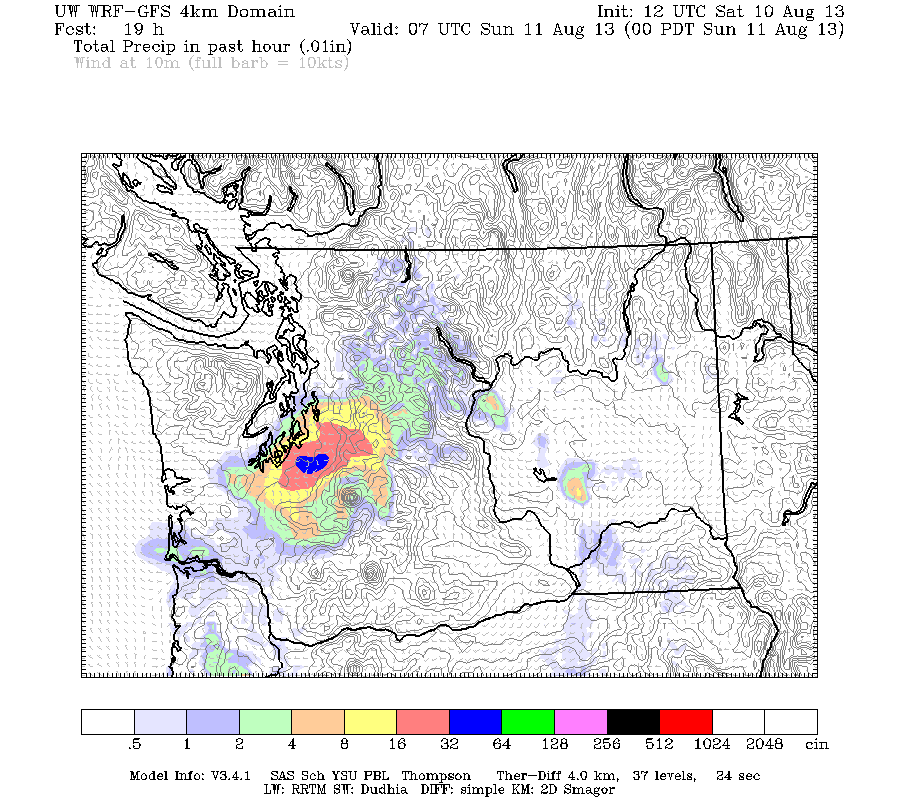 |
| Valid 12:00 am PDT, Sun 11 Aug 2013 - 19hr Fcst: UW 8/10/13 12z WRF-GFS: 4km 1-hour Precipitation |
Here's the radar right now. More storms are continuing to fire up. Looks like it will be an exciting evening. :)

Charlie
No comments:
Post a Comment