11:38 P.M.
Hey everybody. Sorry for not posting for a while... I had a seizure several nights back and screwed up my sleeping schedule, so I've just been really unorganized for the last few days. I'm totally fine now. Regular readers of this blog know I have epilepsy, and I talk about it freely. There were some lessons I learned from my Micronesia trip about my condition, so I'll take some course of action with the University of Washington before my summer is over and see if I can spur some positive changes in the way epilepsy is handled. It's not like I have anything better to do.
I was originally going to write four parts about these thunderstorms we saw, but seeing as time has kept on slipping into the future over the past week, I'm going to abridge parts 2, 3, and 4 and just smush them into one. Last week was amazing, but we have to keep up with the times, you know?
Alright. Let's take a look at what happened last Friday night. My previous blog explained how thunderstorms - and lightning in particular - worked, so if any of the stuff I say here seems confusing, just refer to that blog.
Synopsis:
One of the many great things about the University of Washington's mm5 and wrf models is that the UW keeps archives of the runs that go back at least a month. This is actually the second time I've looked at the model archives; the first time was when I looked at the December 1-3, 2007 Great Coastal Gale, which was a storm for the record books. Check it out on Wolf Read's The Storm King website for more info on that particular storm and a bunch of other intense windstorms to hit the Pacific Northwest. But anyway, I took a look at the model data on the morning of the Friday, the 9th. Thunderstorms occurred the entire weekend in Eastern Washington, but the big event in Western Washington occurred Friday night.
Let's take a look at what the upper-level air pattern looked like that day.
 |
| Valid 05:00 am PDT, Fri 09 Aug 2013: UW 8/9/13 12z WRF-GFS: 36km Resolution - 500mb Vorticity, Heights. |
As you can see, things seemed fairly calm in the upper-levels. The height lines are pretty far apart, meaning that the temperature contrast in the upper atmosphere is not all that great and the jet stream is essentially nonexistent, with the only semblance of it south of the Aleutians. As we transition into autumn and the polar regions cool considerably, we will see the jet stream ramp up. When Thanksgiving comes around, hold onto your hats - that's the stormiest period of the year. But here, things look pretty quiet. The main feature is that there is a large, weak upper-level low pressure system to our south. As far as pressure gradients go, it is pretty weak, but it is providing a little bit of moisture and instability. And that's all it takes to sprout summer thunderstorms in Western Washington.
For the sake of comparison, below is a picture of what the same chart looks like from tonight's run. You can see that it is vastly different with a much more "zonal" (east to west) flow with higher height gradients and therefore higher wind speeds. Our upper-level air is coming straight off the Pacific. This is a more typical summer scenario, but the jet stream (the area with the highest gradients) is usually a bit further north. This is one of the first signs that autumn is approaching... the southward movement of the jet stream. The "cut off" low off Southern California is currently sparking up some thunderstorms into California, Nevada, and Arizona.
.gif) |
| Valid 05:00 pm PDT, Sun 18 Aug 2013: UW 8/20/12 00z WRF-GFS: 36km Resolution - 500mb Vorticity, Heights |
So, we had a super weak low pressure system to our south that was ushering air into Washington. Let's take a look at what this looked like at the surface.
 |
| Valid 08:00 am PDT, Fri 09 Aug 2013 - 3hr Fcst: UW 8/9/13 12z WRF-GFS: 4km Resolution - 10m Wind, Sea-Level Pressure, 2m Temp |
You can see that the surface winds do not show as much of a pattern. This is typical. Because of its topography and proximity to the cold, upwelled waters off the Pacific, the Pacific Northwest has many diurnal wind patterns. These amplify during the day. There is some weak counter-clockwise circulation near the Tri-Cities, indicating that there may be a super weak low pressure center there. If there is, it is too minuscule for the isobars to reflect it.
 |
| Valid 05:00 pm PDT, Fri 09 Aug 2013 - 12hr Fcst: UW 8/9/13 12z WRF-GFS: 4km Resolution - 10m Wind, Sea-Level Pressure, 2m Temp |
As the day went on, Eastern Washington heated significantly, and Western Washington heated up a fair amount as well. When air heats, it expands and becomes less dense, and it rises. If you look closely, you can see that the wind barbs on either side of the Cascade crest are pointing toward it. This is called "upslope flow," and this convergence of winds caused cumulus congestus clouds to form over the Cascades. By 5, many had developed into thunderstorms.
 |
| Upslope winds converging at the crest of a mountain ridge. Retrieved from a UCAR COMET Program online textbook. |
As the day went on, the CAPE (Convective Available Potential Energy) rose. CAPE is a measure of the potential energy an air parcel would have if it rose a certain distance in the atmosphere. If an air parcel has high CAPE, it means that it is buoyant and will tend to rise. Rising air leads to clouds, which lead to thunderstorms. Take a look at how the CAPE changed from 5 a.m. to 5 p.m.
 |
| Valid 05:00 am PDT, Fri 09 Aug 2013: UW 8/9/13 12z WRF-GFS: 12km Resolution - CAPE |
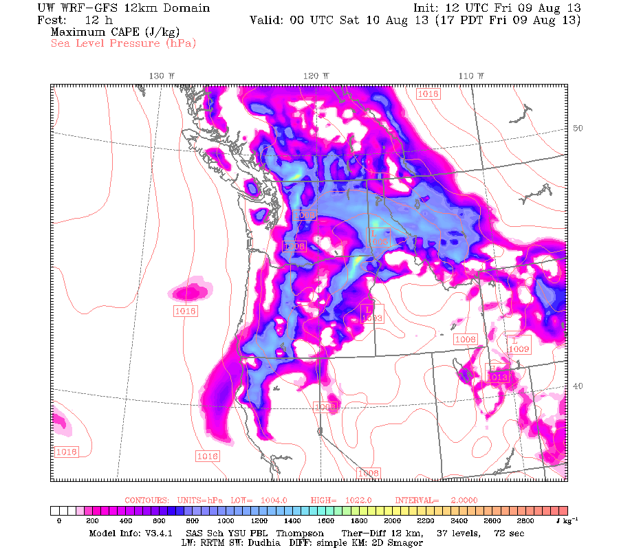 |
| Valid 05:00 pm PDT, Fri 09 Aug 2013 - 12hr Fcst: UW 8/9/13 12z WRF-GFS: 12km Resolution - CAPE |
MUCH greater instability nearly everywhere, especially near the mountains. The high CAPE and unstable air was responsible for allowing these thunderstorms to grow to exceptional heights... 30 - 35 thousand feet. Storms of this height are common east of the Rockies, but they are very rare here in Western Washington. It's noteworthy if we get to 20,000 feet, as most of our storms are in the low teens.
But instability in the atmosphere doesn't necessarily mean convection. In order to form clouds, you have to have moisture. Well, this air with southerly origins had a fair amount of moisture associated with it. The map below shows the dewpoints at 11 p.m. This isn't 80+ dewpoint Pohnpei humidity, but it's pretty high for the Pacific Northwest, especially for Eastern Washington, and it was definitely noticeable.
 |
| Valid 11:00 pm PDT, Fri 09 Aug 2013 - 18hr Fcst: UW 8/9/13 12z WRF-GFS: 12 km Resolution - 2m Dewpoint |
This model got the general idea of thunderstorms in the mountains perhaps drifting down into the lowlands spot on, but it did horrible with the actual finer details of predicting when and where the thunderstorms would come. It didn't predict a graceful apocalypse for Friday night, but it certainly did for Saturday night, with more emphasis on the "apocalypse."
The National Weather Service didn't need the specific precipitation predictions though. Once they saw the general setup, they knew to post red flag warnings all over the state. And post they did, both for Washington and points south and east. The flash flood watches were posted because these thunderstorms could drop a ton of rain in a short period of time, and some flash flood warnings were issued due to thunderstorms doing just that. State Route 20 in the North Cascades was submerged under nearly a first-down's depth of mud due to the heavy rain. More on that below.


The nice thing about these summer thunderstorm events is that most of the action in the lowlands occurs when it is dark out. The thunderstorms build up in the Cascades all day and finally drift into the lowlands as the sun sets. Since they are slow movers, you can see the lightning a far ways off in the distance. That was one of the things that made Friday night so spectacular. Even before the main event came through, you could see heat lightning over the Cascades as the sun began to set.
Our main action came with a line of thunderstorms that swept through the area around midnight. The pictures below are from the UW interactive radar on the UW Atmospheric Sciences website. I also scratched down a few notes during the storm... I've posted them below. I had a whole bunch of other notes related to the number of strikes I saw in 5 minutes (I used a stopwatch) at certain periods throughout the night but I can't find them right now. The general trend was down from a high of 65 when I first measured them at midnight (there were more before) that gradually dropped to 41 to 27 and to some other double digit number before hitting the single digits, and the show was over by 3. I look eastward out over the lake, so I couldn't see any of the strikes over downtown and points west.
~10:30 ... take dog for a walk, see flashes of lightning in the far distance. No thunder.
12:02: Took a look back at the lightning much closer. Still no thunder. 65 strikes in 5 minutes (300 seconds) so a strike every 5 seconds. Amazing.
12:24: can start to hear thunder barely. Looked at radar and saw precip heading NW to Seattle.
12:27: Precip is almost at Seattle. Just heard a definitive thunder. First one of the night.


Anyway, that's the main evolution of the stuff we saw. As the pictures below show, there were plenty of thunderstorms on the eastside on Saturday, but we didn't get any.

Repercussions:
This storm sparked tons of fires. I've called it "The Graceful Apocalypse" because it was so beautiful in Western Washington. Eastern Washington got hit hard.
There was one particular cell that dropped incredible amounts of rain over North Cascades SR 20. I've seen reds on radar before, but I've never seen a blue. That's mind-boggling. I wish I was there.
 |
| Extremely heavy rain over the North Cascades. Retrieved from Cliff Mass' blog (I cheated. It's in the public domain though). |
Here are some pictures the WSDOT guys took and posted on their Flickr of a huge mudslide that this cell caused. The slide was up to 25 feet deep in places. Can you imagine how hard it must have been raining?
 |
| Better put my summertime chains on |
 |
| How rude of the mud to just barge in like that |
 |
| Look how deep those front wheels are in! |
 |
| It's amazing that this tree was left standing! |
 |
| It looks like good fishing habitat. If only there was water... |
 |
| Can't think of any more creative captions. |
Roads weren't the only things that were destroyed. I heard that there were 50+ fires in Eastern Washington at one point. The picture below was taken by Mike Cushman and shows the Milepost 10 fire as seen from Rock Island in Chelan County. I contacted Mr. Cushman a week back asking if I could use his photo for my blog, as his copyright license prohibits redistribution without permission. He didn't respond.
When in doubt, break the law.
Check out his Facebook page and personal website.
 |
| Milepost 10 fire as seen from Rock Island - Chelan County, WA. Taken 8/10/13. Retrieved from cushmanphotography.com. Author: Mike Cushman |
I also heard that there were as many as 2,500 lightning strikes over Eastern Washington on Saturday alone. I wish I had more facts to give, but that's all I have right now.
Explanations:
I asked Scott Sistek, meteorologist and web content producer for KOMO in Seattle, three questions about the storm, and I've paraphrased the questions and answers below. Scott's answers are in blue.
1.) Why was there so much lightning? Our winter thundershowers that roll through often have one or two big lightning strikes with loud thunder, but these storms had the opposite.
I think it has to do with the much stronger updrafts. We saw cloud tops at 30,000-35,000 feet with some of those storms. These updrafts create more static electricity in the storms to create the lightning.
2.) Why was there so little thunder? At one point, I counted 65 strikes in 5 minutes. I didn't measure the number of audible individual thunderclaps I heard, but it was far less than 65. There may have been a faint, constant rumbling in the background, but I didn't hear it. I was surprised by how quiet the storm was.
I've had a number of people remark on the lack of thunder. I think maybe what might have been going on were again -- these were very, very tall thunderstorms - much taller than we're used to around here. So some of that lightning might have been so high in the sky - on the tune of 30,000 feet instead of maybe 10-15,000 feet our thunderstorms usually are - that by the time the thunder reached the ground the air had absorbed much of the sound. Usually about 5 miles is as far as you'll hear thunder so if you think about it, anything higher than 25,000 feet would qualify. :)
* Personally, I have heard thunder over 10 miles away, so I think there are more factors at work than just distance. Humidity in the air might play a role... the nature of the bolt (intra/inter cloud vs. cloud-to-ground) may also.
3.) These strikes seemed to be primarily cloud to cloud strikes extending miles across the sky. Also, they seemed to be more "gentle" strikes than other lightning I've witnessed. They just beautifully filled up the sky to make a pleasant show rather than an apocalyptic scene (this is where I came up with the "Graceful Apocalypse" name).
This might also be related to the height of the storms - the nearby clouds provided a better "path of least resistance" to release the charge than the distant ground.
The bottom line is that this event was unusual. It's not completely out of left-field, but it's not something that happens very often. I didn't realize how much lightning these storms could have and how many fires this lightning could start. I was also unaware of the flash flooding risk. I had never seen any event like this before. But I definitely hope I will again.
To leave you with something interesting, here's a video of a beautiful, beautiful flash that filled up the whole sky. I took it from my house after the peak of the storm. I'm not saying the Coen Brothers directed this lightning bolt, but it shows up decent on camera. In person... unbelievable.
Stay Sparky,
Charlie
Ended 4:33 A.M. 8/19/2013
No comments:
Post a Comment