2:16 p.m.
Alright, I have to give credit where credit is due. Both Scott Sistek and Cliff Mass, my two favorite weather bloggers in the Pacific Northwest, blogged here and here about how we have seen record nighttime/early morning warmth as of late. These blogs are far better than mine... I suggest you read them. Not necessarily in place of my blog, but, if you really want to learn about the weather of the Pacific Northwest, their blogs are the place on the web to visit.
Now, I know that the phrase "record warmth" may seem a little out to left field for most of you. That's because we are not talking about record maximum temperatures, but because we are talking about record high minimum temperatures. They are the little brother of the record highs we all know and love, and as such, they are often overshadowed by their elder's achievements. But we have been warm at night as of late. I have to admit that, while I did know that our minimums were higher than normal, I had no idea of the magnitude of the departure from average until I took a peek at the aforementioned blogs, and it was probably because I'm still quite familiar with the Micronesia minimums, where you would be jumping for joy if the temperature plunged to 75 and the dew point to 70 because you knew that a restful night of sleep was just around the corner. Let's take a look at the statistics from the past month and see our recorded temperatures versus the averages for this time of year.
The three plots below show the recorded temperatures as compared to the average temperatures for the past 12 weeks. This minimum heat wave is occurring throughout the state. I don't have access to the charts for other Oregon, but you can bet your bottom that it'd look pretty darn similar.
 |
| Plots comparing recent data to extremes and averages. SeaTac Airport: Temperatures Over the Last 12 Weeks (GMT). Retrieved from (University of Washington) Live From Earth and Mars - GRAYSKIES - Pacific Northwest Weather Resource website. |
 |
| Plots comparing recent data to extremes and averages. Walla Walla: Temperatures Over the Last 12 Weeks (GMT). Retrieved from (University of Washington) Live From Earth and Mars - GRAYSKIES - Pacific Northwest Weather Resource website. |
 |
| Plots comparing recent data to extremes and averages. Quillayute: Temperatures Over the Last 12 Weeks (GMT). Retrieved from (University of Washington) Live From Earth and Mars - GRAYSKIES - Pacific Northwest Weather Resource website. |
Just to drive the point home on how consistently warm it has been, take a look as the 2-week chart from Sea-Tac below. It uses the same data as the 12-week chart, but it is zoomed in for optimal viewing convenience.
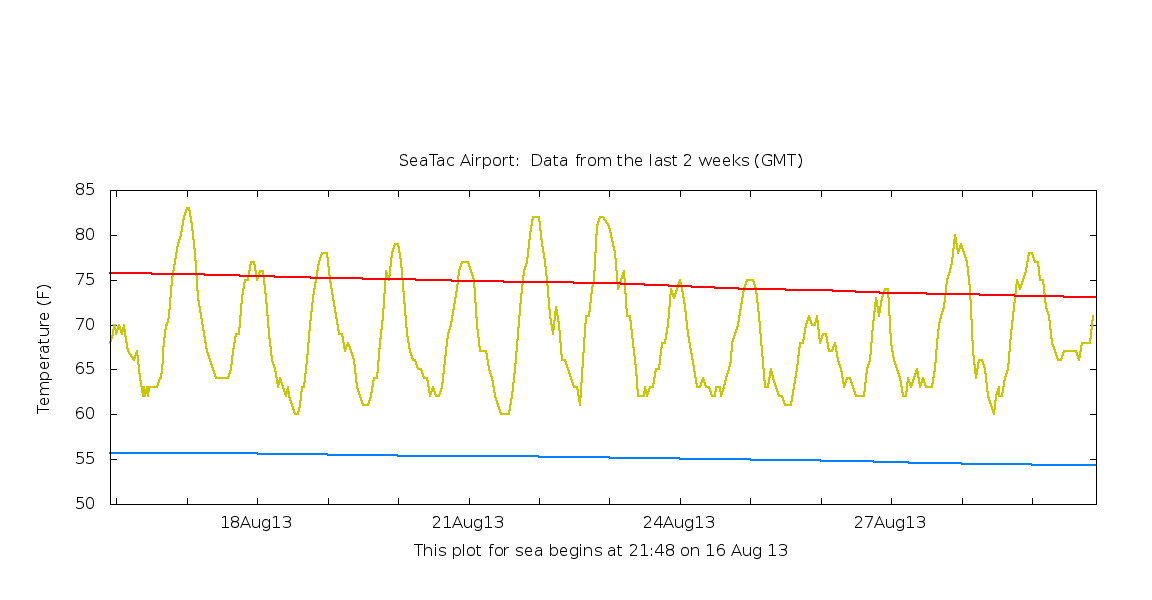 |
| Plots comparing recent data to extremes and averages. SeaTac Airport: Temperatures Over the Last 2 Weeks (GMT). Retrieved from (University of Washington) Live From Earth and Mars - GRAYSKIES - Pacific Northwest Weather Resource website. |
 |
| Valid 05:00 pm PDT, Sun 01 Sep 2013: 925 mb Temperature, Heights, and Winds. UW WRF-GFS 12km Resolution: Initialized 00z Sun 2 Sept 2013. Retrieved from the (University of Washington) Pacific Northwest Environmental Forecasts and Observations website |
Usually, our winds aloft are northerly, but as you can see in the chart above, they are currently southerly. When we get southerly winds, we get higher dew points (the dew points over the ocean are actually quite low because the water is so cold). Water vapor is a greenhouse gas, which means it is very good at absorbing and emitting infrared radiation, and not all of this infrared radiation is reflected back out to space. Therefore, there is a net "insulating" effect from the high dew points. And these high dew points have also been responsible for the amazing thunderstorms we have seen this summer, most recently in early-mid August for Western Washington. Although we haven't been seeing intense electrical storms 24/7, we have been in a pattern similar to the one shown above for much of the summer, with southerly winds aloft bringing increased dew points into the area. Additionally, we have not had the classic "marine pushes" that we usually see to cool us down because east-west pressure differences have been small due adjacent high pressures over the inland Pacific Northwest and off the West Coast.
The picture below is from the NWS Seattle office and shows the monthly temperature and rainfall statistics compared to average. As you can see, the average low was either the warmest or second warmest on record for every place except Hoquiam.

The previous record at Sea-Tac was 58.4 degrees back in '67. I think it's safe to say we annihilated that record. Measurements used to be taken at the Federal Building downtown, and the record there was 59.1 degrees in July 1941. Credit to Scott Sistek for providing that statistics, which I would certainly spent hours trying to find myself.
Minimums still look below average for the coming week, but not extraordinarily so, and dew points will not get above 60. I suspect this is welcome news for most people. As for me... I've hardly noticed the humidity. Micronesia may have given me humidity discomfort immunity for life.
Thanks for reading!!!
Charlie
Ended Monday, September 2, 2013
1:03 a.m.
This comment has been removed by the author.
ReplyDeleteThanks for the write up! Most recent CAPE values are looking pretty impressive!
ReplyDelete