5:26 p.m.
 |
| The last (days of) summer. Source: Wikimedia Commons. Picture URL: http://en.wikipedia.org/wiki/File:Leonardo_da_Vinci_-_Ultima_cena_-_ca_1975.jpg |
From an astronomical, meteorological, and metaphorical point-of-view, His last meal is Friday night. Granted, Summer isn't quite emanating brilliance like Mr. Christ in Leo's little sketch, but just like Christ, He doesn't have that much longer to live. I'll see if I can reserve a spot in the Seattle Times for an obituary on Sunday.
Last week, summer was alive and well. This week, it is on its deathbed. Some are in denial, but most realize that the summer of 2013 will forever pass away. Now is the time for those who love summer to say their goodbyes. Proles throughout the Pacific Northwest will likely be sobbing a-plenty on Saturday as temperature drops into the mid 60s and rain arrives, but they will need to take their ceremonies inside on Sunday as fall truly shows that it's here to stay for a whole three months. While it is true that we have seen some dreary days this summer, we've always rebounded to a warm and sunny pattern with the occasional (or in some cases, more-than-occasional) summer thunderstorm. And while there is a chance that we may experience some brief, temporary summer reincarnations during October, our days of sizzling summer sun are over.
Even though summer is on its deathbed, it still has a pulse. It may be slow and irregular, but it's still there. Take a look at the current 500-millibar height chart below.
.gif) |
| Valid 05:00 am PDT, Tue 17 Sep 2013: Absolute vorticity, 500mb heights (meters). UW WRF-GFS 36km Resolution: Initialized 12z Tue 17 Sep 2013. Retrieved from the (University of Washington) Pacific Northwest Environmental Forecasts and Observations website. Chart URL: http://www.atmos.washington.edu/~ovens/wxloop.cgi?mm5d1_x_500vor+///3. |
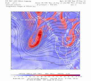
As you can see, we've got zonal flow from the northwest and a small trough over our area. It is 6:15 p.m. as I write this sentence, so the axis of the trough to the west of Seattle in the above picture is probably over the Cascades now. A setup like this with a cool, northwesterly jet is commonplace for autumn, and I would say that summer's pulse had officially _______________'ed if it wasn't for a slight warming over the next couple days as a ridge comes to the rescue.
 |
| Valid 11:00 pm PDT, Wed 18 Sep 2013 - 42hr Fcst: Absolute vorticity, 500mb heights (meters). UW WRF-GFS 36km Resolution: Initialized 12z Tue 17 Sep 2013. Retrieved from the (University of Washington) Pacific Northwest Environmental Forecasts and Observations website. Chart URL: http://www.atmos.washington.edu/~ovens/wxloop.cgi?mm5d1_x_500vor+///3. |
Last week was definitely summer's grand finale, and all we are left with are a few undetonated mortars for summer's delinquent sons and daughters to set off. It looks as though they are currently planning to set off their explosive devises on Thursday, allowing highs to reach the mid 70s in Seattle and low 80s further south and towards the foothills. Wednesday and Friday morning are prep and clean-up days, respectively, so there might be a few showers rolling around, but they will be light and scattered in nature.
Friday afternoon is our prep day for autumn. A weak front crawling eastward will finally begin to bring some precipitation to the coast. This front isn't particularly strong, but it will act to push the ridge eastward and "open the gates" to the Pacific storm track. And that is when our summer will end.
 |
| Valid 02:00 pm PDT, Fri 20 Sep 2013 - 81hr Fcst: 3-hour precipitation (inches), 10-meter wind (knots). UW WRF-GFS 12km Resolution: Initialized 12z Tue 17 Sep 2013. Retrieved from the (University of Washington) Pacific Northwest Environmental Forecasts and Observations website. Chart URL: http://www.atmos.washington.edu/~ovens/wxloop.cgi?mm5d2_x_pcp3+///3 |
It won't end in a super dramatic fashion, as the front will disintegrate and fall apart as it nudges the ridge eastward and gets torn up by topography, but a quick look at the same 500-millibar chart on Saturday clearly shows that summer is out and autumn is in.
 |
| Valid 02:00 pm PDT, Sat 21 Sep 2013 - 105hr Fcst: Absolute vorticity, 500mb heights (meters). UW WRF-GFS 36km Resolution: Initialized 12z Tue 17 Sep 2013. Retrieved from the (University of Washington) Pacific Northwest Environmental Forecasts and Observations website. Chart URL: http://www.atmos.washington.edu/~ovens/wxloop.cgi?mm5d1_x_500vor+///3. |
The ridge is no more, and a solid storm is slithering southeast on a track to terrorize the metropolis. And by Sunday evening, all hope is lost.
 |
| Valid 05:00 pm PDT, Sun 22 Sep 2013 - 132hr Fcst: 3-hour precipitation (inches), 10-meter wind (knots). UW WRF-GFS 12km Resolution: Initialized 12z Tue 17 Sep 2013. Retrieved from the (University of Washington) Pacific Northwest Environmental Forecasts and Observations website. Chart URL: http://www.atmos.washington.edu/~ovens/wxloop.cgi?mm5d2_x_pcp3+///3 |
On that note, uh, have a good one folks.
Charlie :)

No comments:
Post a Comment