11:39 A.M.

Valid 04:00 pm PST Wed, 18 Jan 2012 - 36hr Fcst - UW 4km 12z WRF-GFS 24-hour snowfall
As I was looking over the models and the spread in forecasts being made by different people and organizations, I was thinking about some changes that should be implemented in UWs Atmospheric Sciences Department. In order to apply for a Ph.D, aspiring graduates must have forecast at least one Seattle snow event to an overall "standard" set by the department. If they forecast it well enough, they can go ahead with their Ph.D if all of their other prerequisites are met. If they don't quite make the cut, they can always wait for next winter.
As hard as it is to forecast this stuff, it's even harder when the media gets involved. Newspapers and tv stations will often feature these huge articles on how much snow the Seattle area will get. What did the Seattle Times say for today? "Megastorm Looms for Area." Sound pretty scary, and it is sure to attract a lot of readers. It turns out that it may have been a bit premature though, at least for Seattle. As a forecaster, you find yourself being the hero or the goat based on how accurate your forecast is, especially if it is catered towards certain types of weather the public is wishing for (i.e. snow).
This morning's forecast models showed the storm coming in slightly further south on Wednesday. Seattle would still be on the cold side of the storm and would receive snow, but the heaviest amounts would be shifted southward. Seattle would not bear the brunt of the snow... instead, places like Centralia would. Now, I'm expecting less than four inches north of Everett (with Bellingham getting nothing), 4-7 inches from Tacoma to Seattle, and over 7 inches south of Tacoma. Isolated spots in Southwestern Washington could pick up over a foot of snow, and the Southern Cascades (in Washington and Oregon) will see apocalyptic amounts measured in feet. This is slightly different than what other forecasts are calling for... Cliff Mass of the University of Washington was calling for 2-6 inches from the storm, while the National Weather Service is predicting anywhere from 5-10 inches of snow from Tacoma to Everett with higher amounts to the south and lower amounts to the north.

This is a very complicated forecast, and I am going to show you some model charts I have never shown you before to give you a better idea of what is in store for us. First, let's look at some ensemble charts.
There are two general types of models: operational and ensemble. Operational models take the atmosphere at one point in time and run equations to predict the weather into the future. These models usually run at 00z and 12z GMT, with the NOAA models also running at 06z and 18z. I commonly post pictures from operational models on my blogs... in fact, the picture at the very top is from this morning's operational UW WRF-GFS. Ensemble models, on the other hand, take a whole bunch of operational models and combine them into one giant "supermodel" by averaging the statistics from each model run together. With ensemble models, we are able to express not only an "average solution" for the runs but also identify areas where different models deviate with respect to the average solution.
Take a look at the ensemble chart below. It shows the sea level pressure (SLP) expected at 7 A.M. Wednesday. Unfortunately, this chart is from last night's 00z ensemble runs (I couldn't get to the one for the 12z runs for today for some reason) but it is still useful because it identifies uncertainties in the track of the storm that will impact us.

Valid 07:00 am PST Wed, 18 Jan 2012 - 39hr Fcst - UW 12km UWME Mean & Spread" SLP Standard Deviation and Mean
This chart shows two things, the deviations in SLP (marked by gray shading) and the ensemble mean (average) for the SLP (marked by blue isobars). Here, we see a low pressure system approaching the mouth of the Columbia, which is in line with the 12z WRF-GFS run from this morning and supports relatively less snow in Seattle (2-6 inches) compared to previous model runs. The really important thing to look at there though is the shading, which dictates the spread in the SLP predictions of each of the ensemble members. South of the Columbia, the shading is light, denoting little disagreement with the models in regard to SLP predictions. North of the Columbia, however, there is greater uncertainty, meaning that the models are predicting a larger spread of surface pressures there. By looking at this chart, a meteorologist can immediately know that most runs indicate a pretty similar SLP structure to the south of the center of the low pressure system, but that the models are in less agreement of the pressure configuration north of the low. In fact, some ensemble members may even take the whole low pressure system and shove it up to the north.
I don't use ensemble models as much because they aren't very convenient for making a quick forecast and our operational models generally do a pretty good job, but they are very useful when the operational models are in complete disagreement because they give you specifics on where they are disagreeing while still providing you with a great average of all the solutions that is many times far more accurate than any of the operational models. Ensemble forecasting is the way of the future... in fact, UW has an ensemble system dedicated to the layman called "Probcast" (you can find it @ "UW Probability Forecast" on my list of weather likes on the right) that is generally very accurate.
Second, let's look at some cross sections!!! Cross sections look at a vertical slice of the atmosphere over a large region and show the characteristics of it at a certain time. Cross sections are very important to look at right now because we are in the midst of an overrunning event, where warm, moist Pacific air overruns cold, arctic air.
There are a lot of things to look for in these charts, but I first want you to look at the far right section of the chart, which represents Bellingham and the mountains north of it. The left side of the chart goes south past Olympia.
In this first chart, notice how there is a "wedge" of blue lines at the surface. This, folks, is the beginning of a strong, northeasterly wind pouring into our region as the storm approaches.

Valid 04:00 am PST Wed, 18 Jan 2012 - 24hr Fcst - UW 4km 12 WRF-GFS Orting, WA, to Vancouver, BC
Tomorrow morning, some moisture arrives in gusto, which you can see by the colorful shaded area in the top left. Cold air is still pouring into Western Washington from the north.

Valid 10:00 am PST Wed, 18 Jan 2012 - 30hr Fcst - UW 4km 12 WRF-GFS Orting, WA, to Vancouver, BC
Look now though! There is so much cold air that it has displaced the moisture and created a sort of "block" preventing much moisture from coming further north! So while the north gets extremely cold air, this cold outflow will actually make it more difficult for the moist air off of the Pacific to encroach and bring more snow to the area. It will be very important to monitor the ways these different air masses interact. If the arctic "wedge" ends up being weaker, it will be easier for more moisture to make it further north. On the other hand, if the arctic air ends up overpowering the maritime air, places to the north of Everett or so may see much less snowfall than is forecast.
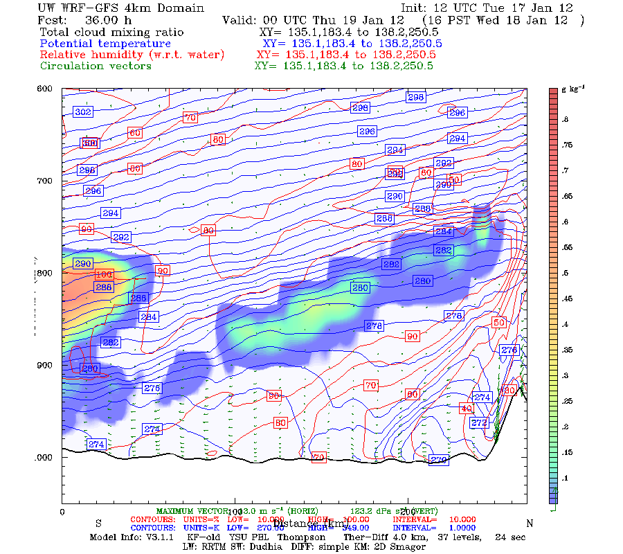
Valid 04:00 pm PST Wed, 18 Jan 2012 - 36hr Fcst - UW 4km 12 WRF-GFS Orting, WA, to Vancouver, BC
This has been a very long post, and I hope you got something out of it. I'll offer another review of the models tonight. Here, I wanted to give you my general forecasts and introduce you to some concepts about ensemble forecasting and the interaction between arctic air and Pacific air. Later tonight, I'll get down to business and talk about updated forecasts... maybe I'll even include some real time stats to reflect the battle between the two different air masses!
Charlie
Nice blog post - thanks for providing the detail on the various inputs used for modeling/predicting what is happening. If you haven't already posted this, I would be interested to know why the European modeling is considered to be more accurate than that produced by the NWS (or whomever). If this has been covered in a previous blog post, please point me to that. Again, thanks for an informative blog & keep up the good work!
ReplyDeleteThe European model just has a better track record when it comes to predicting weather. If I remember, the Euro, on average, is able to forecast five days out with the same accuracy that the top American model (the GFS) is able to forecast 4 days out. I wish the American models were better, but as of now, the Euro is king
ReplyDelete