9:47 P.M.
I gave a schpeal on snow this morning, and now it's time I give another one. Many places around Seattle saw significant accumulations today while other places saw very little snow. My brother reports that my house down by Lake Washington between the floating bridges got 4 inches today, but the college dorm where I am currently staying only got an inch. I went up to Whidbey Island today to update my weather station (more on that later) and while Whidbey did not see any steady snow like the Seattle metropolitan area did, it had some highly localized snow showers that were interesting and fun to watch. It always amazes me how localized these showers can be. My mom and I were driving down one of the numerous highways on South Whidbey today and we drove from clear skies to heavy snow in less than 50 yards.
Here is a brief list of snow totals from today, just to give you an idea of the variability in snow totals around here! This list was compiled by Scott Sistek of KOMO, and you can find Scott Sistek's current discussion and forecast for the future here.
Kirkland - 7.5"
Bothell - 7"
Mill Creek - 7"
North Bend - 5"
Marysville - 4"
La Conner - 4"
North Seattle - 2.5"
West Seattle - 2"
Here's a picture from one of my favorite websites, the UW SnowWatch website. You can find it @ http://www.atmos.washington.edu/SNOWWATCH/.

UW SnowWatch 09:39pm Sun 15 Jan 2012 24-hour snowfall
The amounts on this picture are estimated, but the general shading gives you a good overall picture of who saw the heaviest snow. The dorm I live in is right by Portage Bay, which got significantly less snow than Capitol Hill and areas east. Kirkland and Bothell were the big-time winners from this storm.
Here are some pictures of snow from around the Sound today! All of these were taken by members of the "Pacific Northwest Weather" group on Facebook, which is a group of local weather enthusiasts who love to discuss weather models and share weather-related stories/photos from across the Pacific Northwest and beyond. If you aren't a member, you should definitely look into joining! Check it out @ http://www.facebook.com/groups/109882929060639/.

Issaquah, ~3 P.M. Photo credit: Stephanie Schlosser

Seattle, ~3 P.M. with 4 inches of snow. Look at the Bank of America Tower in the background! Photo credit: Nick Vaughn

"My attempt at making a snowman. I've guess I've lost those skills" - Nicholas Efthimiadis, North Seattle ~ 3 P.M.
One more thing... it is ICY out there tonight, so be very, very careful when you are driving! Roadway ice is the #1 weather-related killer in the Pacific Northwest by a long shot, so please be careful out there, and don't end up like this...

Portland, ~4 P.M. Photo Credit: Jeff Raetz
So, what can we look forward to now?
It's tough to say, because the forecast, particularly for Tuesday-Wednesday, has been so unclear over the past few days that NOAA has actually sent out aircraft over the Pacific to obtain additional observations to plug into their models with the aim of getting a more accurate forecast. NOAA does this with hurricanes all the time, but I've never heard of them doing something like this before. Getting a model consensus on this Tuesday-Wednesday storm will be critical, because since the models diverge on the strength and location of the low, they also differ wildly on more extended forecasts for the rest of the country, with some models keeping the arctic air bottled up in Canada while others blanket the eastern half of the country with snow.
The forecast for tomorrow into Tuesday morning is still difficult, but it is much, MUCH easier than the late Tuesday-Wednesday time frame, so let's start with it first.

Valid 04:00 pm PST Tue, 17 Jan 2012 - 48hr Fcst - UW 4km 00z WRF-GFS 24-hour snowfall
This shows the 24-hour snowfall forecast in our area from 4 P.M. Monday to 4 P.M. Tuesday. Tomorrow, the snow will be a little late to start around our area, but it should start picking up in places by the afternoon. Still, it will be pretty spotty, with some places getting dumped on while other places receive nothing, and Seattle could very well be "snow-shadowed" by the Olympics tomorrow and receive very little snow. It will be important to watch the radar tomorrow, as it will prove to be the best tool for predicting snowfall amounts several hours into the future, although the models are in reasonable consensus about bringing some heavier snow through the area into Tuesday morning. We'll just have to see how this situation plays out.
Now, let's talk Tuesday-Wednesday.
I'm getting tired, so I'm just gonna give you the basics. The GFS model gives us several inches of snow before shifting to heavy rain.

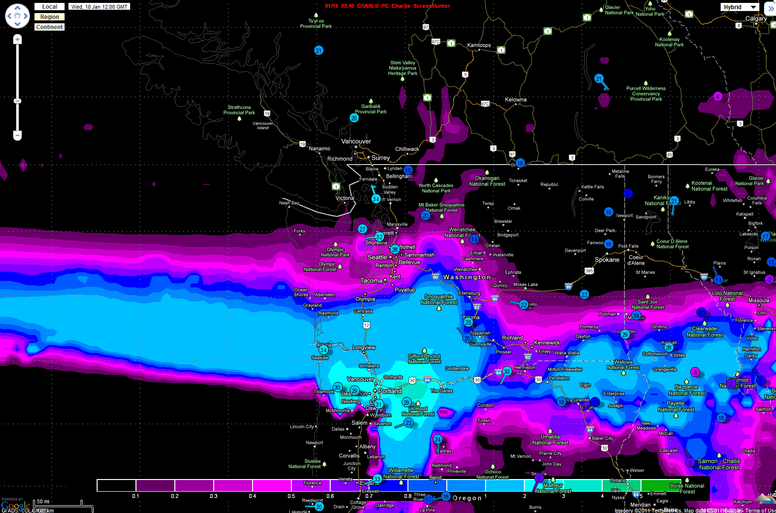
Valid 04:00 pm PST Wed, 18 Jan 2012 - 72hr Fcst - UW 4km 00z WRF-GFS 24-hour snowfall
This scenario would give Seattle around 2-6 inches of snow, but it would all change to rain and wash away, so I'm not particularly excited about it.
The other American model, the NAM, is showing a strong system making landfall on the central Oregon coast. Such a landfall would give Seattle cold temperatures, but little precipitation. Portland, on the other hand, would see over 6 inches of snow.

Valid 01:00 pm PST Wed, 18 Jan 2012 - 69hr Fcst - 00z NAM 6-hour precip, SLP
Now, the Euro...
I'm a little nervous about putting the latest run of the European Model up because it would generate dangerously high expectations for snow in Seattle, and the last thing I want is a bunch of people frustrated with me because they didn't get the foot of snow the Euro promised them.
I'm going to show two shots from the latest Euro... one is the 3-hour snowfall over our area at 60 hours, and the other is the three hour snowfall at 72 hours.
Valid 04:00 am PST Wed, 18 Jan 2012 - 60hr Fcst - 00z Euro 3-hour snowfall
You can see a huge band of snow streaming over our area. It moves slightly north, and then stalls directly over Seattle for 12 hours.

Valid 04:00 pm PST Wed, 18 Jan 2012 - 72hr Fcst - 00z Euro 3-hour snowfall
After this, we would warm up, but if this model run was correct, Seattle would see over a foot of snow. I do not think that will happen, but it is food for thought.
Finally, here's the deal on my weather station. I got it set up both on the Weatherlink website (http://www.weatherlink.com/user/charliep127/) and, most recently, at the Weather Underground website (http://www.wunderground.com/weatherstation/WXDailyHistory.asp?ID=KWACLINT8). Both of these links give you live access to the current weather conditions on Southern Whidbey Island. It's definitely something to check out!
Be sure to write any snow totals you got from today on the comments!!!
Charlie
Capitol Hill got 4+ inches.
ReplyDeleteNice! Capitol Hill really got clobbered from this storm, I could see the snow piling up there looking across from the University District
ReplyDeleteThanks for the incredibly detailed analysis! So I guess we'll have to wait and see. Cool that NOAA has sent out the planes!
ReplyDeleteWhat is the source of the last two diagrams (the NAM model) that you posted? It appears that it may be something that you have developed? If so, it is a great way of looking at the model output & I would be interested to see more of these in the future. In any case, kudos on your blog page - one of the best IMHO!!
ReplyDelete