Tuesday, January 11, 2011

Our Dilemma

Tuesday, January 11, 2011
8:26 P.M.
Thankfully I don't have this dilemma. Who would possibly want to go to college?

I have to make this quick, as additional homework warrants priority, but I just felt like I needed to have a quick note to explain what is going on and all the hype that we received earlier this week and how none of it is coming true. Before, the models were predicting a historic snow event. The biggest snow event in our lifetimes, possibly even in our parents lifetimes if everything panned out correctly. It could have been the snowiest week in Seattle history. This is not an exaggeration. That possibility seemed very real, and models were continuing to forecast it only 4-5 days out, which meant that it was well within the believable range of probability, though admittedly far from a slam dunk. 

Then, all of the sudden, the low pressure system was forecast to go to our north, and here I am at my house, distraught with "what could have been" with a measly .10 inches of snow on the ground, forecasting a changeover to rain in an hour or so. 
Here is the dilemma - should forecasters tell the truth to the general public about what they see in the models? Or should they wait before claiming there could be a gigantic snowstorm? Is it better to give the public advance notice of a serious event developing? Or is it better to wait until you are sure to prevent confusion from occurring and your tv ratings/reputation from going down if you are wrong?

I supported what the media did on this one - they went ahead and forecast a giant snowstorm and then changed when the models changed. Sure, it got super hyped up and nothing really happened, but if the original forecast was right and the media didn't let people know, people could become stranded. People could die. And I think that we can all agree that massive disappointment is better than death. 

What I feel like the general public and even some professional forecasters don't realize about forecasting is that is a field of probabilities. There are ensembles of models, and they all show something slightly different. There is a feature called "probcast" at the uw that gives a forecast of a probability of what things might occur based on averages of different models. It can be found at http://www.probcast.com/. Although it is not very specific and still has a lot of work to do with regards to development, it is a great start, and it is often very accurate for short range forecasting, particularly with weather events where the models vary wildly and you can't really pick a solution. When meteorologists make a forecast, they generally look at a model and interpret what it is saying. But all the models show different things, so wouldn't it make more sense to give a probability of what might happen? I think it would.

But the question is if this is friendly to the consumer. A lot of times, I'll be asked if we will get snow or not, and I'll start explaining convergence zones and wet bulb cooling and adiabatic warming/Chinook winds, and people will just interrupt me and say, "look, do I have to do my hw for tomorrow?" Do people want a probability forecast that is more accurate and gives a better glimpse of what truly goes on in the profession I plan to enter, or do people just want a simple number? I'm guessing they would just want a simple number with an icon (smiley face sun optional). There are meteorologists who are opposed to forecasting with probabilities because in their eyes, one thing is going to happen, and we are going to forecast the one thing we think is going to happen. Those opposed to probabilistic forecasting also point out the contradictions in National Weather Service forecasts. They might say "How can you have a 50 percent chance of snow, and still have it accumulate to 2 inches? Does that mean it will snow 2 inches if it doesn't snow at all?" Obviously, it means more like it will so 2 inches if it does snow, but the wording can be a bit ambiguous at best in NWS forecasts. Even though the NWS forecasts can be confusing sometimes, I still think that giving PoP (probability of precipitation) forecasts along with quantitative forecasts make the most sense.

So what should the commercial sector do in regards to these storms? Should they give a big heads up? Should they play it safe? My answer is that they should give a big heads up if it occurs in the models more than twice, and mention it if it has occurred at least once. But they absolutely NEED to stress the probability aspect of it. I actually wrote an essay about computer models for my computer science class (maybe I'll post it on here sometime for ya'll to read), but the bottom line is that forecasts are chances of what might happen, they are not what will happen. Commercial stations need to give larger warning times (as a safety measure) but STRESS UNCERTAINTY. They glaze over it, but when snow-crazy kids like you Garfield students read the forecasts, "there is a slight possibility of two feet of snow" becomes "Jeff Renner says there could be two feet snow," which becomes "Jeff Renner says it is going to snow two feet" which becomes "OMG!!!!!!!!!! IT'S A NEW ICE AGE!!!" Of course, King5 contradicts itself often because the forecasters explain that it might happen, and then all of the sudden Parka Boy (Jim Foreman) comes in and tells us how we could get devastated with two feet of snow, but nobody listens to the "could" part of it.

When I write these forecasts, I try to show you a little bit of my world in forecasting - I give models, I give probabilities, and I generally take more risks in forecasting and mention things further in advance than the tv stations and even the NWS or Cliff Mass. But I cannot stress enough that this is a field of probabilities, and while it is fun to look at models of crazy events happening (and beneficial to those who could be affected), nothing is certain and things are bound to change with each model run.

I would like to hear from you guys on this! Is it better to play it safe, or to give lead advance time? Would tv weather be more interesting if they showed computer models? Do you have a favorite tv station for weather? Do meteorologists stress enough that every forecast is a forecast of something that has only a chance of occurring? Post on this blog! I'd love to hear your opinions. Cliff Mass routinely gets 20 comments per post, often times more. Let's bring the ruckus and knock him off his top spot for once!!!

Charlie

0:50

Sunday, January 9, 2011

To Be Or Not To Be?

Sunday, January 9, 2011 9:04 P.M.
As I try to memorize this stupid... er... wonderful passage, I am faced with an utterly more important question. Will we, or will we not, see a major snowstorm? 
And the answer is... I really have no clue. But it is looking less likely.
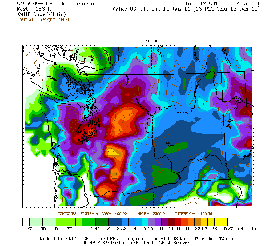
One thing meteorologists look for in models is run to run consistency and trends. The previous models, especially the one Americans use the most, the GFS, were all very, very consistent in bringing a historical snow event to at least some part of the Pacific Northwest. However, now all the models have shifted the storm track much further north. This means we would be on the warm side of the storm. As you can see in the map above, the low pressure center is now approximately over Ucluelet (Southern Vancouver Island). This would mean that instead of getting a cool northerly wind to cause snow to the area, we would get a warmer southerly wind that would change it all to rain. We may see 1-3 inches before the switchover, but compared to what the models were showing before, this is nothing.But there is a little bit of good news. I did save money on my car insur...Just kidding. But really, there is some good news. Models before had the storm even further north, up by the northern tip of Vancouver Island. Now, it is about 200 more miles south. If it is 200 miles more south, we WILL see a snowstorm of historic proportions. Precipitation is not the issue. The temperature is. And the mountains will see tons of snow regardless. Here is a 24 hour snowfall period forecast from 4 P.M. Tuesday to 4 P.M. Wednesday. The storm is also expected to get here sooner, Wednesday instead of Thursday.
Whether tis nobler to have a storm come in to our southOr to suffer the travesties of one to our northOk I give up. Gotta study.But listen closely. If this storm does come to our south, we will see a foot, perhaps more, of snow. So now is the time to prepare.You stay classy, planet Earth.Charlie

Friday, January 7, 2011

A Major Snow Event?

Friday, January 7, 2011
6:07 P.M.
This is what 2 feet of snow looks like

Hey everybody! It's been a while since I last posted. It has been all college apps... a word of advice to underclassmen... get them done early! But, I successfully sent all my January 1st deadline college applications, and I am ready to roll!

Thankfully the weather has been fairly benign lately, and there hasn't been much to talk about. But then I woke up this morning, and I saw this.
This is a map of predicted 24 hour snow accumulations from 4 P.M. Wednesday to 4 P.M. Thursday. At face value, this would mean a FOOT of snow in Seattle. To top it off, more snow comes pouring in later on this model, which would bring the storm total to over two feet in our area before it is all said and done.

Now, I don't want everybody to get excited. There are often events like this that show up on the models and everybody gets super excited only to have snow not fall at all. Out of three models, two are showing significant snow, and one is showing a snowy transition to rain. I'd say we have a pretty good chance of getting some snow. The question is if we get a switchover to rain, or if it stays all snow and we just get walloped (like above). First, you need to have cold air in place. Cold air will start to filter into the area this weekend, with highs in the mid 30s or so. While I would like to have the air be colder, it is cold enough for snow (air can be above freezing and the precipitation can still be snow, particularly if the air is dry or the precipitation is heavy). Now, take a look at the graphic below.


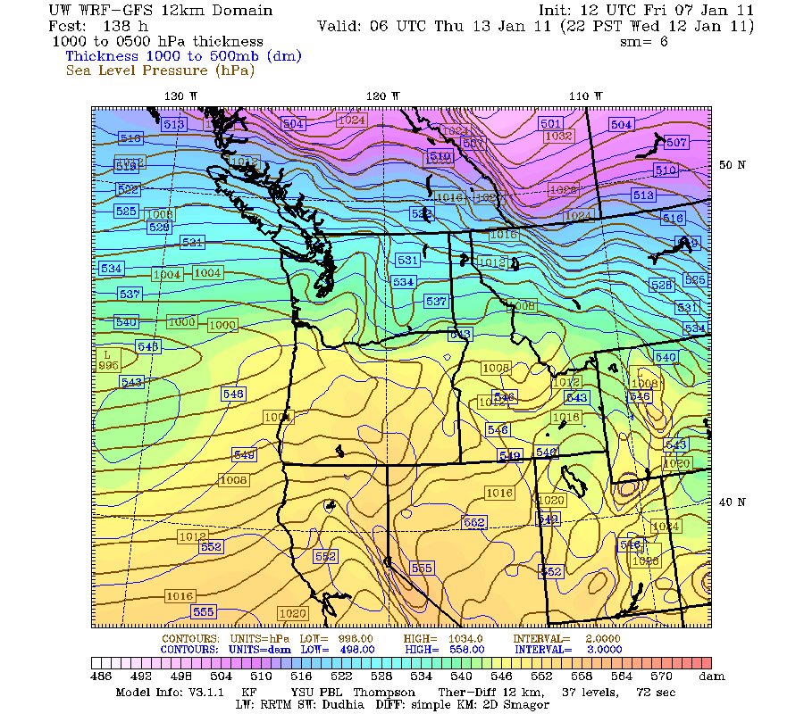
It is important to understand why we might have such a big snow storm, and what ingredients are needed to come together to deliver a potentially historical punch. The scenario shown above is the PERFECT scenario for gobs of snow for Seattle. We have a split jet stream in the upper atmosphere, with one branch coming into our area from Canada and one coming off the Pacific. You can see a developing low pressure system in the far left corner of the picture. This comes onshore just north of Astoria, as evidenced down below.
It is a little hard to make out exactly where the center of the low is, but it is near the mouth of the Columbia River in this diagram.

The crucial key here is that it goes close enough to us to provide us with ample moisture, yet it goes south so it draws in a cold northerly wind. That's why the models are going crazy with snow amounts. If this does verify, we could see the biggest snowfall we have seen in at least 15 years, going back all the way to December 1996.

But it is a big if.

I'll keep you posted. :)
Charlie

0:56

Saturday, December 11, 2010

Pineapple Express

Saturday, December 11, 2010
2:18 P.M.

Wait a minute...


There we go. :)

The word is out that we will likely see some of the biggest flooding since January 2009 on some rivers, and January 2009 was a record-breaking event for the Snoqualmie @ Carnation and saw major flooding on many other rivers. Some rivers are certain to flood, like the Skokomish, and others will probably flood also, like the Snoqualmie. Thankfully, the Green River doesn't look like it will quite reach flood stage, although with qpf (precipitation amount) forecasts going upwards over the last few model runs, we will have to keep a close eye on the situation there. 
We have a lot to talk about, and I'm sorry I couldn't get to it earlier. I was studying for the ACT, which I took this morning. Anyways, the leading edge of the warm front from this system is over us now and is bringing light to moderate rain to many areas, which will only increase in intensity as the weekend progresses. The radar below shows that a lot of rain has already spread over the area, and it will only get heavier as time goes on.

We also have some snow issues to deal with today. While this will mainly be a rain event, there is some cold air trapped in Eastern Washington and that cold air is causing snow from the passes eastward. Rocky Canyon, east of Cle Elum, is getting moderate snow right now.
Snoqualmie Pass is getting dumped on as well.
This cold air will work its way out as milder air from Hawaii starts to invade the area. Until then, expect heavy snows in and east of the Cascade passes. We could also encounter some sleet and freezing rain as well during the transition.

But the real story here will be the rain. Freezing levels will shoot up all the way to 8,000 feet with this storm, which means pretty much everything falling in the mountains will be rain, save the volcanoes and highest peaks. The new models showed generally 2-3 inches of rain in most parts of the lowlands in the 24 hour period between 4 P.M. tonight and 4 P.M. Sunday. You can see some areas of white in the graphic below, and those areas illustrate where there is the potential for over 10 inches of rain in 24 hours. 
This is a serious flooding event, but it isn't too out of the ordinary. We usually get a storm like this every year or so, and this one won't be as serious as the ones of November 2006 and December 2007, which caused catastrophic flooding on many rivers. However, I do expect major flooding on many rivers flowing off of the Cascades and Olympics for several reasons. The forecast models have been trending wetter and commonly underestimate precipitation amounts in Pineapple Express events, which is why I feel like we are going to get more serious flooding than the National Weather Service's hydrological center is predicting. 

Looking at the forecast model above, which is the 12z GFS, you can see an intense rain shadow northeast of the Olympics. While some areas of the Olympics will likely see a foot of rain in this period, some places 60 miles away might get only .01 inches. That is 1200 times less rain! Just goes to show how pronounced the Olympic rainshadow can be. So if you live north of Seattle, you'll start to feel the effects of the rainshadow, and if you live by Port Townsend, you'll probably be wondering what all this fuss about flooding is about. Because the winds in the middle atmosphere are traditionally very strong with Pineapple Expresses, they drop a ton of rain over the mountains via orographic enhancement, and then sink rapidly on the leeward sides, preventing much more precipitation from falling (at least until they hit the Cascades again).

We will have to be careful of urban flooding as well. While we won't have any convective downpours like we did that one morning last week, we will see a lot of rain in a fairly short period of time, and with all the leaves down, expect storm drains to get clogged up and large puddles to result.

Latest river forecasts can be found HERE: http://water.weather.gov/ahps2/forecasts.php?wfo=sew&view=1,1,1,1,1,1,1,1&toggles=10,7,8,2,9,15,6

Stay dry, and stay safe :)
Charlie

Tuesday, December 7, 2010

Flooding?

Tuesday, December 7, 2010
5:44 P.M.

I know... I know... I haven't updated it in a while. Same story as always... I've been extremely busy. I thought senior year was supposed to be a breeze! Not with my class schedule... we will see if all my hard work pays off and I get into college. Hopefully I can at least get in somewhere.

Alas, this will be a short post, as there is more work to do in the homework department. However, I've been watching the models very intently for the past few days and they have been EXTREMELY consistent in showing a Pineapple Express event. The nature of the event, however, has been anything but consistent. Model runs have ranged from bringing all the rain to Oregon to a bulls-eye over Seattle to bringing the majority over Vancouver Island. They seem to be trending further northward. Things could change, and it will be wet around here, but I don't expect major river flooding issues in the Central and South Cascades. This means that the Green River will probably escape the flood threat, which is good news. The Olympics, North Cascades, and southern mountain ranges of British Columbia (Vancouver Island and the mainland) look to get a lot of rain, but we just aren't sure how much. The latest model runs don't stall the front as much either, which means more areas will get rain but less overall than if it stayed over one specific area.

In the meantime and in between time, it's raining heavily over the lowlands right now, and we could see an inch out of this storm system over the next couple days. The "Pineapple Express" over the weekend has the potential to give us even more significant rains, but the model runs as of now don't show a ton of rain for Seattle. It is a situation that bears watching.

And no snow in the foreseeable future.
Thanks for reading. :-)

Charlie

0:09 minutes