1:03 P.M.
 |
| 01:24 am PDT Sun 07 Apr 2013 - Langley Hill Radar |
Last night, a surprisingly powerful storm rolled through the area. It's a shame that the brunt of it came while most people were sleeping, as I'm always down to watch a good storm, but I can get a glimpse of what it may have been like by looking at past radar and satellite images. And let me tell you, the storm that rolled through looked pretty legit.
If you take a look at the radar above, you can actually see the general form of the low pressure system. You can see the heavy rain ahead of the system, but the really amazing part is that little rain-free area off the coast. That area indicates the exact center of the low. Low pressure systems rotate counter-clockwise around their center in the northern hemisphere, and that little "hook" to the west of the rain-free area represents the front out ahead of the storm wrapping around to the west of the storm due to the counter-clockwise rotation of the low. This feature is known as the "bent-back occlusion," or, as Cliff Mass likes to call it, the "poisonous tail" of the low. In this system, the area of heavy rain centered over the Langley Hill radar looks to be much more poisonous, but in other systems, the bent-back occlusion is generally the area where the strongest winds are found. In the Hanukah Eve storm of 2006, many locations in Western Washington received their highest gusts a little after 1 A.M., right as the bent-back occlusion was coming through.
Here's a water vapor image of a strong bent-back occlusion back from February 4, 2006 just to give you an idea of what these features look like. The occlusion is to the west of the dry slot off the Washington coast.

Although a small bent-back occlusion is visible on the radar, it wasn't picked up very well on the satellite. Take a look at the infrared satellite picture I posted below, and try to find the occlusion.
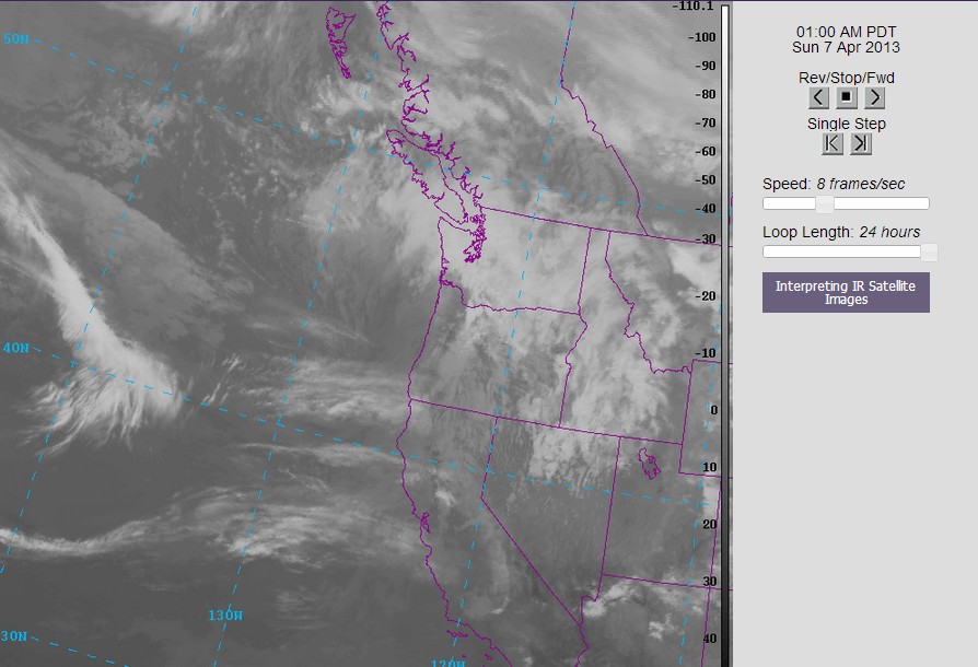
If you look really closely, you can see the curl of the cold front extending upwards through the Willamette Valley before it turns into an occlusion and bends back down to the south off the Washington Coast. I put a satellite loop below. Try to see if you can find the time where the low undergoes cyclogenesis and develops the occlusion.
If you can, you are well on your way to becoming a meteorological genius. If you can't, just keep practicing.
The models had hinted at a storm like this, but the details were tremendously muddy. I decided to take a look at the forecast discussion from the Portland NWS office Friday night, and here's what they had to say.
  MODELS ARE HAVING TREMENDOUS DIFFICULTY IN HANDLING THE NEXT SYSTEM
  FOR SATURDAY NIGHT. GIVEN THE UNCERTAINTY WILL ISSUE A LOW-END WATCH FOR THE OREGON
  COAST WITH THE AFTERNOON PACKAGE AND INCLUDE POSSIBLE GUSTS TO 60 MPH
  ACROSS THE MORE EXPOSED COASTAL SITES.
The gusts ended up being higher than forecast, and the Willamette Valley, which was just expected to be breezy, was issued a wind advisory last night in accordance with the rapidly developing low. Off the Oregon Coast, Cape Foulweather had sustained winds to 46 mph with a gust to 75, the Yaquina Bay Bridge (near Newport, OR) had sustained winds of 50 with a max gust of 60, Timberline had a gust of 89, and even Portland had a gust to 44. Pretty impressive stuff. If you look at Saturday night's model run, you can see the tight, tight, tight gradient across the Willamette Valley.
 |
| Valid 05:00 am PDT Sun, 07 Apr 2013 - 12hr Fcst: UW 00z WRF-GFS: 12km 10-meter wind speed, sea-level-pressure |
If you got the Tuco reference, you are well on your way to becoming a methamphetamine drug lord. If you didn't, just keep practicing.
This storm is in some ways reminiscent of the February 7, 2002 "South Valley Surprise," which you can read more about here. This is Wolf Read's "The Storm King" website, which is a great resource for learning about Pacific Northwest windstorms and reading about past events. The South Valley Surprise was a storm that hit south-central Oregon with essentially no warning and was much more severe than this one.
It also reminds me of the big snowstorm we saw in January of 2012 where a low was forecast to move to our south, leaving us snowless, but ended up coming further north, bringing Seattle a good six inches of snow and burying places like Centralia in 1-2 feet of the white stuff. Needless to say, I got this forecast right on the button... check out the "Models Pessimistic, Charlie Optimistic" blog under recent posts. Even in high school, I was the best forecaster in Washington for snow events. Don't believe me? Ask anybody at Garfield about that snowstorm with the huge bolt of lightning. They'll vouch for me.
Charlie
No comments:
Post a Comment