5:04 P.M.
From Wednesday, April 10, 2013:
"We'll have some rain coming in Friday afternoon, but I'll bet my life on having a strong convergence zone somewhere in the area Saturday afternoon due to a cool, moist, onshore flow splitting around the Olympics and converging somewhere along Puget Sound. If I'm still alive on Sunday, you'll know I was right."
Well, it looks like I will be alive on Sunday, and more alive than I've ever been.
Alright, well know that ya'll know I'm like... the best forecaster ever... let's actually talk about what is happening outside right now.
 |
| Camano Island Radar: 04:58 pm PDT Sat 13 Apr 2013 |
This is the radar picture taken from the Camano Island radar at 4:58 pm today, and you can see that there are a lot of showers around Puget Sound. Interestingly enough, there actually look to be two convergence zones, one over the San Juans and another, stronger one directly over the Seattle area. Because there are so many other showers in the area, it is a little tough to make out zone over Seattle, but as evidenced by the band of precipitation and the extremely heavy showers embedded within this band, it is there.
The scale on the right uses different colors to denote different rainfall rates. More specifically, it measures dBZ (decibels relative to Z), and is the meteorological measure of Z (reflectivity) of a radar signal reflected off an object. This is a logarithmic scale, so small increases in the scale represent much larger increases in reflectivity (and therefore precipitation in most cases). Whenever you see reds on this radar, you can be assured that there is heavy rain or hail in the area, and if you look closely at this picture, you can see that the reds are centered right over Seattle.
 |
| UW Campus looking out over Red Square: ~ 5 pm |
I've counted about 4-5 lightning strikes at the UW in the last 15-20 minutes or so, which is quite a few for a springtime northwest thunderstorm. There was some hail mixed in with the rain at one point, which indicates strong updrafts and instability within the shower, as hailstones cannot form without updrafts suspending them to a point where they can accumulate ice before they finally become too heavy and fall to the ground. Right now (5:23), the rain has almost completely stopped, so let's take another look at the radar.
 |
| Camano Island Radar: 05:18 pm PDT Sat 13 Apr 2013 |
As you can see, the rain has moved south of the UW area and is now directly over downtown Seattle. The actual shape of the convergence zone is better defined in this picture.
 |
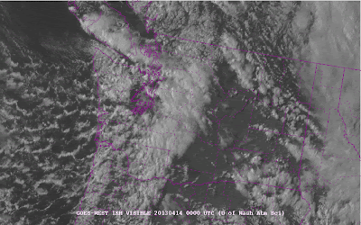
| 1km resolution GOES-West: Pacific Northwest Visible Satellite 05:00 pm PDT Sat 13 Apr 2013 |
You can even see the convergence zone over Seattle on the satellite. See that little finger extending westward from the Central Cascades over to Hood Canal? That's the convergence zone. Another thing to note is the incredible rain shadow over Eastern Washington. Look at how the clouds just completely die out once you move to the east of the Cascade crest and there is downslope flow. Simply beautiful stuff.
With the cold air aloft, there are very low snow levels. The passes are getting hammered, and I even heard of a few snowflakes flying by Western Washington University this morning.
The convergence zone should gradually dampen as we head towards midnight, but I'd still be on the lookout for a couple more strikes here and there. Springtime Pacific Northwest weather... it can be exciting!
Stay safe.
Charlie

No comments:
Post a Comment