1:59 P.M.
Before I elaborate on what I think the weather will be like, I'd like to point out the strength of the front we saw yesterday. Yesterday's front wasn't big and didn't produce a whole bunch of rain, but it was strong and consolidated, and it really packed quite a punch. Look at that picture above! That's a beautiful front. We never were able to get these types of pictures before our coastal radar.
The most interesting weather yesterday, however, occurred after the front passed. There was an abrupt wind shift from southerly to northwesterly, and once these northwesterly winds hit the Olympics, they split and later converged over the north Seattle to give us heavy rain, lightning, and even hail via the famous Puget Sound Convergence Zone.
Take a look at this UW time-lapse shot from the atmospheric sciences building yesterday, and look at the huge wind shift in the late afternoon. It occurs around 3:50 P.M. After the wind shifts, you can see convective motion at the base of the clouds, and rain starts falling 45 minutes later in a Puget Sound Convergence Zone.
This convergence zone strengthened, and Seattle got some particularly exciting weather around 5:30. My Lander 8 floor-mate Jane Kwon was out grocery shopping at the time. She sent me a text at 5:35 P.M. telling me she heard a huge clap of thunder, and then sent me another text at 5:38 letting me know that she was now getting hailed on. If only Jane Kwon had looked at the radar imagery beforehand...
Here is some hail from Kirkland. Photo by Jan Moser, taken from KOMO News.
Meanwhile, places to the north and south were experiencing dry conditions. Check out this picture by Mukilteo last night. Scott Sistek took the photo and I retrieved it from KOMO News.
You can see some cumulonimbus associated with the convergence zone, but Mukilteo is completely dry! Pretty amazing.
Now, let's get on to the forecast.
Here are the current weather advisories over Western Washington as of 8:00 P.M. Saturday evening. The western slops of the Cascades are getting hammered with snow, and thus are under a winter storm warning for 8-16 inches of snow. The Olympics are under a winter weather advisory for lesser snowfall amounts, and the Strait of Juan de Fuca and coast have gale warnings while the sound and San Juans have small-craft advisories.
Right now, the snow is the big story, and the NWS office at Seattle made a little nifty graphic to show this.
I like this guy, it's simple, informative, and gets the job done. Let's take a look from Snoqualmie Pass earlier today, though, so we can really sense how snowy it is out there.
The snow will continue to pile up in the Cascades tomorrow while the Seattle area experiences post-frontal instability showers. These showers will become weaker and more isolated by Monday, and much of Tuesday may actually be dry.
Wednesday, however, looks stormy, and this storm could very well decide if I have to forecast the "s" word for Seattle in my next blog.
Valid 10:00 am PST Wed, 16 Nov 2011 - 90hr Fcst - UW 00z 12km WRF-GFS SLP, 10m winds, and temp
Midday Wednesday, a compact, strong low pressure system will storm into our area. This particular system could give some good gales to the coast, and if it came closer, it could give us some pretty strong winds. For now, it doesn't look to cause us too much damage wind-wise. However, it will pack a lot of rain and mountain snow.
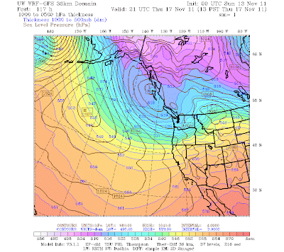
More importantly though, it will usher in a new weather pattern for us. After this storm passes through, we will get cold. Some models are saying we will get cold enough for snow, while others are saying we will see more of a rain-snow mix. The stronger this storm is, the better it will be at digging a trough in the jet stream and pulling down modified arctic air into Western Washington.
In this scenario, the low brings down quite a big of cold air!
Valid 01:00 pm PST Thu, 17 Nov 2011 - 117hr Fcst - UW 00z 36km WRF-GFS 1000-500mb thickness, SLP
At this point, it looks like we could see some pockets of lowland snow next weekend, but I'm not forecasting a wide-reaching lowland snow event at this point. It is just too early. I'd like to see the rest of this run and check out the European and Canadian models before I make any assumptions. It will definitely get much colder though, and the snow will continue to pile up in the mountains. Happy La Nina year everybody!
Charlie


Well put!
ReplyDeleteThanks Joe, I am hoping that a convergence zone will whiten things up for us sometime in this time period :)
ReplyDeleteYes! I would love to have a white Thanksgiving. I think that's asking too much though, it is a ways away. I just hope this winter is better than last. I'm tired of hearing about the east coast and every other place east of the Rockies getting so much cold and snow. It's kind of like the Seahawks every year; it's always "maybe next year".
ReplyDeleteLast year wasn't a bad winter, especially with our November 22nd snowstorm. La Nina caused a lot of snow in the mountains, but it was slow to get started. The 2009-2010 winter was incredibly boring, and I am excited for some lowland snow chances this year! Some of the models are showing it next weekend, but others aren't. I'm cautiously optimistic about our chances, especially if a convergence zone develops when it is colder next week.
ReplyDelete