12:48 P.M
Cut-off low over the central U.S. - September 27, 2011
In the coming days, we will see a rather interesting weather event take place far out at sea over the Eastern Pacific. Currently, there is a gigantic trough around 150 degrees west over the Pacific, and this trough is so deep that it will eventually get "cut off" from the main jet stream and create a circular ring of upper-level winds in the atmosphere to the south of the main jet stream while having precipitation at the surface. Take a look at the 500mb forecast this morning for 1:00 P.M.
Valid 01:00 pm PST Tue, 08 Nov 2011 - 9hr Fcst - UW 12z 36km WRF-GFS 500mb absolute vorticity, heights
Now, look what happens 24 hours later.
Valid 01:00 pm PST Wed, 09 Nov 2011 - 33hr Fcst - UW 12z 36km WRF-GFS 500mb absolute vorticity, heights
Look at that cut-off low! You can clearly see how it is cut off from the main jet stream, which is up in Alaska by this point. And it gets even more cut off from the main jet stream 15 hours later (39 hours from now)
Valid 04:00 am PST Thu, 10 Nov 2011 - 48hr Fcst - UW 12z 36km WRF-GFS 500mb absolute vorticity, heights
Also, look at the jet stream winds at the same time at the 300mb level.
Valid 04:00 am PST Thu, 10 Nov 2011 - 48hr Fcst - UW 12z 36km WRF-GFS 300mb isotachs
Now, look at the 1000-500mb thicknesses. You can see the cold air associated with the low, which makes sense because the now cut-off low pressure system has origins from the Northern Pacific.
Valid 04:00 am PST Thu, 10 Nov 2011 - 48hr Fcst - UW 12z 36km WRF-GFS 1000-500 mb thickness, SLP
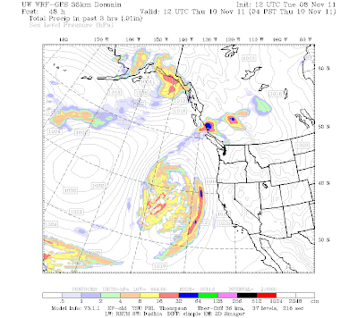
Finally, the precipitation associated with the low.
Valid 04:00 am PST Thu, 10 Nov 2011 - 48hr Fcst - UW 12z 36km WRF-GFS 3-hour precip, SLP
Remember that post last week about excitement in the extended? It was referring to this general system. Back then, however, the models showed this system as a consolidated, non cut-off low giving possibly flooding rains to the Pacific Northwest. Cut-off lows are interesting to look at, but weather-wise, they generally are pretty weak because they are isolated from the jet stream, which provides the temperature differences extra-tropical storms need to grow.
Excitement in the extended? Models are flip-flopping around, but the general message is that we will become cold. Check out what KOMO said this morning in their forecast discussion.
"Some interesting things are now appearing on the super-long-range computer forecast models. The models are trying to bring in some extremely cold air the week of Thanksgiving. It's still way too early to mark it down in pen, but pencil in a continued pattern change as we get into the heart of November."
I am pretty much convinced at this point that we will get into a colder pattern with heavy snow in the mountains, but I am not convinced about a full arctic outbreak over our area yet. Some models have shown it, and others have not. It's exciting to speculate, but we need to be realistic too. Snow is not looking likely in the lowlands this weekend, but the mountains will get a dumping, and that is perfectly exciting enough for me.
Thanks for checking out the blog!
Charlie


I love your weather blog. It's the first one I go to everyday. Now that winter is approaching. We don't have enough weather blogs here in the PNW. That's probably because the weather is usually boring. I hope you keep us updated throughout the winter. Thanks!
ReplyDeleteHaha, yeah the summer weather is pretty boring, but we can get some real big storms from time to time. Thanks for reading my blog, I truly appreciate it. Tell your friends!
ReplyDelete