10:08 A.M.

Sea Surface Temperatures at different points in the Equatorial Pacific on week centered around 9/7/11
The above picture is from NOAA's CPC (Climate Prediction Center). As you can see, there has been a clear trend as of late for a cooling of the SST (Sea Surface Temperatures) in the Equatorial Pacific. This trend is also reflected at deeper depths. Last year, we saw one of the largest La Nina events on record, but we transitioned to a neutral pattern after that. However, around August, there was a strengthening of the trade winds, resulting in increased upwelling in the Eastern Tropical Pacific. When you have upwelling, you have cooler SSTs because the water at the surface is being continually replaced by deeper, cooler water. That is why the the water off of Los Angeles is generally 20-30 degrees cooler than the water in the Gulf of Mexico in the summer. Upwelling is strongest closer to shore, so when I go tuna fishing off of the Washington coast, I have to go around 50 miles out to get to warmer, bluer water, as upwelling also increases nutrients toward the surface. In fact, the ancient Peruvians knew an El Nino was coming when the fishing off of their coast became poor. There was a decrease in upwelling, resulting in less nutrients and less fish.
But enough about fishing. Let's talk about weather. If you take a look below, you will see a bunch of models showing their predicted SST anomalies for the Nino 3.4 region, which is usually regarded as the most reliable region for telling if a El Nino/La Nina event is forecast or occurring.
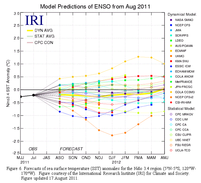
Dynamical and Statistical 3.4 SST anomalies from the International Research Institute for Climate and Society Updated 8/17/11
I looked all over for a more present chart, but this is all I could find, and I took it off of Cliff Mass' blog. Thanks Professor Mass!
As you can see, the models are all over the place. However, the NCEP CFS model clearly shows La Nina conditions, and this model is generally regarded as the most accurate.
The models, along with decreasing SSTs and a historical tendency for weaker La Ninas to follow major events, have prompted NOAA to raise their previous La Nina Watch to a La Nina Advisory. Basically, this means that they are now forecasting La Nina conditions for the coming winter, whereas before they were uncertain.
Most of you know what a La Nina means for us; we will have cooler than average temperatures and above average precipitation this year, most pronounced after January 2012. We will also have a higher probability of above average snowfall in the mountains and in the lowlands. I don't know if they have snow days in college, but I'm hoping they do. And for those still in grade school, you may get an unexpected day off or two this winter.
For current La Nina conditions, check out the "Tropical Pacific SST" link I have on the right side of this blog. Or, you can go here: http://www.cpc.ncep.noaa.gov/products/analysis_monitoring/enso_update/sstanim.shtml
You stay classy, planet Earth.
Charlie
No comments:
Post a Comment