9:09 P.M.
Making an acronym that sounds like an actual word (aka: not MOFACASOSWWWW - Major Outbreak of Frigrid Air, Copious Amounts of Snow or Other Severe Winter Weather in Western Washington) actually took me a really long time. And I'm sorry I haven't been updating this, the weather has been boring and I've been absolutely swamped with schoolwork. However, there could be some interesting weather on the horizon and the quarter just ended, meaning that although I still have a ton of college apps to do my schedule has lightened up slightly.
So, lets go through this scale.
LAWES level 0: You are on a planet that has the ingredients necessary for snow
LAWES level 1: Models are showing a chance of snow beyond a week out, 0-20% chance of snow
LAWES level 2: Models are showing a chance of snow within a week, 20-40% chance of snow
LAWES level 3: Models are all showing a scenario that would easily produce snow within a couple days, 40-60% chance of snow
LAWES level 4: Places around the area are already getting snow AND snow is forecasted for Seattle, 60-99 % chance of snow
LAWES level 5: Snow is occurring, 100% chance of snow (derp)
Now, notice how there are no measurements for how strong a Seattle snowstorm could be. But have no fear! That's what suffixes are for.
Ending in:
.1 - 0-2 inches of snow
.2 - 2-4 inches of snow
.3 - 4-6 inches of snow
.4 - 6-8 inches of snow
.5 - over 8 inches of snow
.6 - board the next plane to Panama
So a level 5.6 (below) would mean that snow is occuring and that you should leave the country if possible. Photo props to Alex Jonlin. That storm brought 21.5 inches of snow to Seattle in 24 hours.

Now that that is out of the way, let's discuss the weather forecast. This week is boring. If you want to know about this week, go to a different blog. However, things get rather (pause) "interesting" (sly smile and rubs his hands together) next week. The atmosphere will shift into a classic La Nina pattern, with a HUGE ridge over the eastern Pacific and then a trough on the eastern coast of it (us), directing arctic air down from Canada into the western U.S. Now, there are a lot of questions remaining about this scenario - how cold will the air mass be? How far west will it go? Will it be deep enough to cross the mountains into Western Washington? Seeing as the models have been inconsistent, I am giving this a LAWES advisory level 1 (no specific sublevel), which means there is a 0-20 percent chance of snow occuring in the lowlands. I will keep you posted on if things change. One thing is for certain though. The rest of the country will get extremely cold. We just don't know if the arctic high will go west enough for us to get some of the cold air.
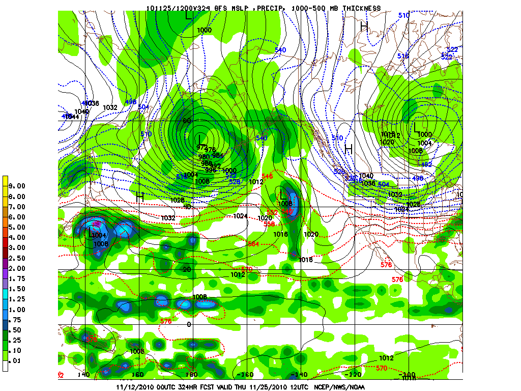
This model shows the weather forecast for a whopping 2 weeks out. That is way too far out to look at individual storms. However, you can look at trends. Here, the models show an arctic high diving into Western Washington and giving us cold air. That's what all this fuss about snow is. We will see if it comes true!
Have a nice night!
Charlie
P.S. The Garfield News Network needs another weatherman! If you are interested in the position, let me know, and we will see if you can get the spot!
No comments:
Post a Comment