Wednesday, March 16, 2011

Nuclear Energy

Wednesday, March 16, 2011
12:33 P.M. 


Hello everybody, today I am not going to talk about weather. Instead, I am going to talk about nuclear power. The fission and fusion of atoms can cause massive destruction. If I remember right, the largest hydrogen bomb, the Tsar Bomba, which was detonated by the Russians in 1961, had the power equivalent to 58 million tons of T.N.T. Even harder to believe, it was a SCALED DOWN version of a bomb that originally had the explosive power of 100 million tons of T.N.T. As is, the bomb could incinerate the whole country of England. It was around 4,000 times bigger than the bomb that was dropped on Hiroshima. Thankfully, apart from the two that ended World War II (I won’t discuss politics here), none of these bombs have ever been detonated as an act of unprovoked warfare. However, there was considerable scare in the Cold War, when bigger and bigger bombs were being built. And as you can see, there is good reason why. When we discovered Russian missle silos over Cuba, we came as close as we have ever been to a thermonuclear war (thermonuclear bombs, ones involving the fusion of Hydrogen into Helium (like the Tsar Bomba), are vastly more powerful than the fission bombs which break apart Uranium and Plutonium atoms that were seen in Hiroshima and Nagasaki. So in this way, atomic energy can be our worst nightmare.

Some nuclear bomb test (don't know the name)

Tsar Bomba video. Camera sucks, but look at the expanding shockwaves!

Hiroshima (left) and Nagasaki (right)

But atomic energy can also make our dreams of reliable, clean power for everybody come true. I have believed, and still believe, even with all these nuclear crises in Japan, that nuclear power is the way to go if we are going to stop global warming with coal and create clean, cost-effective amounts of energy without destroying the environment like hydroelectricity, wind power, and solar power (not to mention the unreliable nature of them). Nuclear energy has one of the lowest accident rates of ANY industry and has gotten much, MUCH safer. Of course, you shouldn't put nuclear power plants in areas that are prone to natural disasters (as we have recently found out), but still, nuclear energy is clean, reliable, and efficient. When we implement it correctly, nuclear energy is a tremendous gift. I believe it is the only feasible solution to combat global warming and ultimately save our planet. 

Let me first explain how nuclear power works. This is a very simplified version, but basically there are fuel rods of Uranium enriched with Uranium 235 which is best for fission. A controlled reaction of fission takes place, and temperatures are cooled by using water. This is the most important part, because if there is no cooling agent, the rods melt and you get a nuclear meltdown. Then, this heat goes to water and creates steam, which then powers turbines. This is what generates prodigal amounts of electricity. Finally, the steam cools in the classic cooling towers you associate with nuclear power plants. Here is a picture of a power plant

Look at all that steam!

As you can see, nuclear fuel generates a tremendous amount of energy. And the amount of fuel used to generate this type of power is tiny compared to coal power plants and hydroelectric dams. And forget about wind and solar power.

However, as we have witnessed with the situation in Japan, there are dangers to nuclear power. First, there was Three Mile Island. Then, the biggest explosion came in 1986, with Chernobyl, killing several thousand people from radiation sickness and causing fallout over a wide area. Now there is the situation in Japan. Nuclear energy used to be very unsafe. Three Mile Island and Chernobyl were not provoked by a natural disaster. Japan has just gotten hit by a 8.9-9.0 (depending on if you trust the U.S. or Japan) earthquake with a resulting tsunami. This will completely devastate even the most "indestructible" structures. 

So there is much to be learned from this. Nuclear power is still the key to our future. But we need to protect our nuclear power plants. We need to put them in places that aren't prone to natural disasters. The Great Plains would be a "great" place for these plants. The only thing they really get are severe thunderstorms, and these nuclear plants are built like a tank. They will survive even the strongest tornado. And they can be shut down in advance if severe thunderstorms are forecast.

But putting them on earthquake fault zones? Not a good idea. There is no way to predict when a 9.0 earthquake  will strike. And when it does, nuclear plants will be running, the cooling systems will get damaged, and you will have a meltdown. 

But if we can find SAFE places to build these plants, away from places with earthquakes, tsunamis, volcanoes, and other events that are hard or impossible to predict, we should build power plants. Coal energy is what will really kill us in the end.

Strangely enough, many environmental groups strongly oppose nuclear energy. But hear me out on this one. I'm a very environmentally-minded guy. Nuclear power is THE cleanest type of power. If we want to save our planet from a much worse fate, we need to invest all of our resources in clean energy.

If anybody that has been affected by the recent events is offended by this article, I am sorry. This is just my opinion. It seems obvious to me that we need nuclear power, but I am just one person, and these events in Japan have affected many people and given us doubts about it. These are just my thoughts and there is no right or wrong in this scenario, and the situation with the plants in Japan is tragic. I wish the Japan the very best in recovering from this tragic natural disaster.

Thanks for reading,
Charlie

Tuesday, March 15, 2011

Tuesday, March 15 2011
12:31 P.M.

I’m actually writing this blog from school right now on Microsoft Word. I can’t actually go through to Blogspot and update it from school, but I think this will do since I can just copy this and put it up when I get home.

First, I want to talk about that windstorm we had on March 10th. I actually pointed out a strong storm in my last forecast that was slated for the 10th (remarkable timing for so long out!) but it came closer than was forecast in that model. It wasn’t that strong, but it followed a near perfect track for giving us strong winds. It rode up the coast, kind of like one of our classic “Sou’westers,” except it had more of a western than southern origin and followed more of a northeast track as opposed to a north-northeast track. Still, it eventually cut right across the Olympic Peninsula and came very close, which, combined with strong southerly upper-level  air flow (when I say southerly, that means it originates from the south) and a compact pressure gradient, gave us surprisingly strong winds from a storm that is relatively small by northwest standards. 


This picture shows the 2 P.M. visible satellite shot from March 9th. You can see two storms. One is by the Queen Charlotte Islands, and another is offshore southest of the 45N 135W line. Both storms have beautiful bent-back occlustions. Normally, this is a sign of a storm that has reached maturity and is starting to weaken. However, that is not true with our more southern buddy. This guy is just getting started. There is a localized low center, but it gets another burst as it runs into the moisture plume that is heading towards Oregon and interacts with a strong jet stream.  


I would use a visible satellite as this storm seems to be shaping up better there, but this was taken at 6 P.M. at night, and there is no light to allow you to see. Therefore, a visible satellite won’t work! As you can see, the storm is developing a much larger occlusion. But as this next picture shows, the visible satellite is a very valuable tool for giving us very close-up details of storms.


This, taken at 10:30 on Thursday (the 10th) shows the storm closing in. It isn't the clearest picture, but you can see the dryish slot offshore. The bent-back occlusion is to the west of that. But this next one is a little clearer.


 This one was taken at 12 P.M., 90 minutes later. You can see a "comma" if you look closely. This is a sign that a storm is rapidly developing.


And at 2:45 P.M., 165 minutes later, the storm has crossed the Olympics. The mountains tear the form apart a little bit but we still get very strong winds when this occurs. And we did!


Today, we saw some thundershowers as a cold and unstable air mass passed over the area. We will probably see the same deal tomorrow and the rest of the week before drying down a bit for the weekend. Some more systems will return next week.


And I will talk about the tragic Japan earthquake and tsunami in my next post. One thing is for sure though... we NEED nuclear power. I really hope all this stuff doesn't scare the world. Just don't build nuclear power plants in earthquake-prone areas. But nuclear power is really the only feasible clean energy source that will work for the world for ages to come. 


Your reading of this blog makes a contribution to my future. Thank you! Have a good one.


Charlie

Monday, March 14, 2011

Storms

Monday, March 14, 2011
12:22 A.M.

I like weather.

I'll update this blog soon.

Monday, March 7, 2011

A Late-Night Update

Monday, March 7, 2011
2:41 A.M.

Hey everybody, I can't fall asleep, so what better thing to do than write a weather forecast? Sounds like a plan to me.

We have been seeing cooler than normal weather for spring, which is actually very typical weather. What I have noticed is that spring weather is usually cooler than normal, but when it is hotter than normal, it is much hotter, which is what brings the average up. But is very common to have upper level low pressure systems drop down from the Gulf of Alaska or come straight across from the northern Pacific and usher cooler air into the region. You can have organized storms, but they are generally weak. What you see more of is frequent shower activity. In the spring, the U.S. sees the highest number of thunderstorms (although they see a lot in the summer as well) and the most severe ones. It is no different here. We don't really get strong storms but we get this frequent shower activity most often in the spring. Our strongest storms are generally in the summer, when there is more heat, but they are more rare.


I'll get to my forecast in just a bit, but I think it is important for you to understand exactly what atmospheric instability is. This is a fairly advanced diagram, but I'll break it down for you real quick. When air rises, it cools, but the amount of moisture in the air stays the same. Cool air holds less moisture than warm air, so at some point, the air cannot hold any more moisture and clouds form. This is pretty normal. But true instability comes when there are large differences in temperature in the atmosphere and lifting mechanisms to produce clouds. When you have very warm temperatures at the surface and very cold temperatures above in a very moist environment, you retain all of that moisture but rise and create clouds as you go higher. If the atmosphere is unstable enough and there is enough moisture, you get this.

These are pictures of supercell thunderstorms (thunderstorms with rotating updrafts, they are very strong and caused by lots of heat and instability)


You get the idea. And if you are really lucky, you get this:

But in Seattle, our storms our much weaker. They can still be strong though. I actually remember this very storm shown below, I was sitting in my sixth period geography class in November of 2006 when heavy rain, hail, and thunder/lightning rolled through. Made for a spectacular shot downtown.


You get the idea. Instability is what causes these showers and storms that we see. Actually, comparatively speaking, our bigger storms with organized fronts have stabler air. But they had instability to get started.

As far as a forecast goes, we will see a weak front come through Tuesday morning, and we will see some showers afterwards. It won't be a major snow event for the mountains but they will see some.


Later, we will see another system roll in. This guy will be a little stronger. It will arrive mid-Wednesday. You can already see the next storm in the distance.


Another one early Thursday... this one will be weak. There is another storm out there that you can see, it will come in and cause some showers, the mountains will get some snow as well, just like all these other storms.


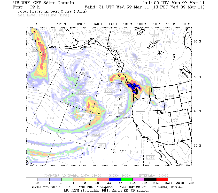
But the big daddy really comes Sunday. Look at this beast!


Unfortunately, most of the action looks to go to California. But this is a real strong storm for early spring. If this were a little closer, it would be a major windstorm for our area. The ocean will see very high waves. I really doubt it will come closer, but it is something to keep an eye on.

I'll let you guys know if things change. Meanwhile, snow levels should remain below the passes, so it will be a great time to hit the passes! In between the storms, we will see those instability showers that I was talking about earlier in this post.

I hope you guys have a great day! Thanks for reading the blog.

Charlie

3:32 A.M. - I'm a little more tired now. :)


Wednesday, February 23, 2011

Snow Still Be Comin'

Wednesday February 23, 2011
11:15 A.M.

Hey everybody! Just a quick morning update. It still looks like some places are gonna see six inches of snow, except the band has shifted a little northward into Snohomish county. Seattle still looks to receive at least three inches or so. We won't really know until later this afternoon. I am still going higher than the NWS forecasts, so I'm leaning towards 4-5 inches or so, but I'm a little tentative to put 6 after these latest models came out. As always, convergence zones are notoriously hard to predict. The forecast will change, I can guarantee you that. And I will keep you updated when it does!

Thanks,
Charlie