2:41 A.M.
Hey everybody, I can't fall asleep, so what better thing to do than write a weather forecast? Sounds like a plan to me.
We have been seeing cooler than normal weather for spring, which is actually very typical weather. What I have noticed is that spring weather is usually cooler than normal, but when it is hotter than normal, it is much hotter, which is what brings the average up. But is very common to have upper level low pressure systems drop down from the Gulf of Alaska or come straight across from the northern Pacific and usher cooler air into the region. You can have organized storms, but they are generally weak. What you see more of is frequent shower activity. In the spring, the U.S. sees the highest number of thunderstorms (although they see a lot in the summer as well) and the most severe ones. It is no different here. We don't really get strong storms but we get this frequent shower activity most often in the spring. Our strongest storms are generally in the summer, when there is more heat, but they are more rare.

I'll get to my forecast in just a bit, but I think it is important for you to understand exactly what atmospheric instability is. This is a fairly advanced diagram, but I'll break it down for you real quick. When air rises, it cools, but the amount of moisture in the air stays the same. Cool air holds less moisture than warm air, so at some point, the air cannot hold any more moisture and clouds form. This is pretty normal. But true instability comes when there are large differences in temperature in the atmosphere and lifting mechanisms to produce clouds. When you have very warm temperatures at the surface and very cold temperatures above in a very moist environment, you retain all of that moisture but rise and create clouds as you go higher. If the atmosphere is unstable enough and there is enough moisture, you get this.
These are pictures of supercell thunderstorms (thunderstorms with rotating updrafts, they are very strong and caused by lots of heat and instability)


You get the idea. And if you are really lucky, you get this:

But in Seattle, our storms our much weaker. They can still be strong though. I actually remember this very storm shown below, I was sitting in my sixth period geography class in November of 2006 when heavy rain, hail, and thunder/lightning rolled through. Made for a spectacular shot downtown.

You get the idea. Instability is what causes these showers and storms that we see. Actually, comparatively speaking, our bigger storms with organized fronts have stabler air. But they had instability to get started.
As far as a forecast goes, we will see a weak front come through Tuesday morning, and we will see some showers afterwards. It won't be a major snow event for the mountains but they will see some.

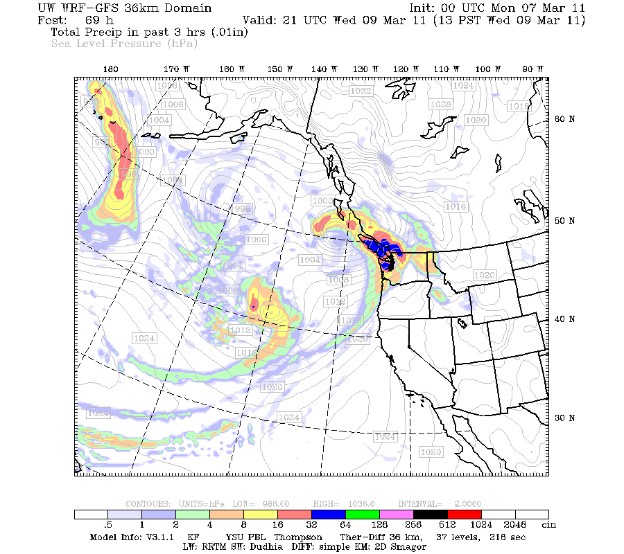
Later, we will see another system roll in. This guy will be a little stronger. It will arrive mid-Wednesday. You can already see the next storm in the distance.

Another one early Thursday... this one will be weak. There is another storm out there that you can see, it will come in and cause some showers, the mountains will get some snow as well, just like all these other storms.

But the big daddy really comes Sunday. Look at this beast!

Unfortunately, most of the action looks to go to California. But this is a real strong storm for early spring. If this were a little closer, it would be a major windstorm for our area. The ocean will see very high waves. I really doubt it will come closer, but it is something to keep an eye on.
I'll let you guys know if things change. Meanwhile, snow levels should remain below the passes, so it will be a great time to hit the passes! In between the storms, we will see those instability showers that I was talking about earlier in this post.
I hope you guys have a great day! Thanks for reading the blog.
Charlie
3:32 A.M. - I'm a little more tired now. :)

Later, we will see another system roll in. This guy will be a little stronger. It will arrive mid-Wednesday. You can already see the next storm in the distance.
Another one early Thursday... this one will be weak. There is another storm out there that you can see, it will come in and cause some showers, the mountains will get some snow as well, just like all these other storms.

But the big daddy really comes Sunday. Look at this beast!

Unfortunately, most of the action looks to go to California. But this is a real strong storm for early spring. If this were a little closer, it would be a major windstorm for our area. The ocean will see very high waves. I really doubt it will come closer, but it is something to keep an eye on.
I'll let you guys know if things change. Meanwhile, snow levels should remain below the passes, so it will be a great time to hit the passes! In between the storms, we will see those instability showers that I was talking about earlier in this post.
I hope you guys have a great day! Thanks for reading the blog.
Charlie
3:32 A.M. - I'm a little more tired now. :)
No comments:
Post a Comment