9:46 pm
Hi everybody! I got back in Seattle late on the 22nd, and now that I've gotten through Christmas, I'm excited to start blogging again once more.
We recently had a major, prolonged snow-producing pattern for our region. I actually went up to Snoqualmie Pass today for a job interview to be a ski instructor (it was a success... I'll be teaching Saturdays & Sundays at Alpental), and there was a TON of snow there. Snow was already plainly visible on the Issaquah Alps, and it really started piling up once we got to Denny Creek, which is about 6 miles west of the Summit. Once we finally hit the Summit, we bore witness to a base that was easily over 6 feet (the Summit At Snoqualmie says their base at Summit West is 93"), and it was even more when we went to Alpental. The trees were absolutely buried in snow; some were fully submerged. It was quite a sight to behold. We brought our dog with us, and he was very happy to be there.
The two pictures below show the snow water equivalent (how much water you would have if you melted down all the snow in one location) for two dates: December 8 (the day I left for Indonesia), and today, December 26. Both pictures were retrieved from the National Operational Hydrologic Remote Sensing Center.


On December 8, the Washington Cascades had a modest snowpack, but amounts were still below normal. The Oregon Cascades were really suffering; there was hardly any there. Now, both places are absolutely covered in snow, and Eastern Washington and Oregon have a ton as well. The Olympics have a healthy snowpack, as does Vancouver Island. There has even been some snow in the lowlands north of Portland and in some places away from the water around Western Washington. There's snow everywhere. Life is good. But if you think it's been snowing hard in Washington, check out what's been happening to Southeast Oregon, Southwest Idaho, and Northern Nevada. One basin in Northern Nevada has 239% of their normal SWE! Pretty much everybody in the West is at or well above normal when it comes to snowpack. The only exceptions are the Bighorn Mountains of Wyoming and a few select stations in the Central and Northern Rockies.
 |
| Credit: USDA/NRCS National Water and Climate Center |
It's been great so far. But things are changing.
At hour 135, the split is even stronger.
How long does this pattern last? It looks like it will last for at least the next two weeks, and I have a feeling it will last even longer than that. The models have repeatedly shown that this pattern isn't letting up. Here's the forecast for hour 384, which is the farthest this model goes out.
We've had a good run, but we could only postpone its arrival for so long. Remember that big blob (not the "Blob;" that has died) of warm water in the tropical Pacific? That whole El Niño thing? Well, El Niños tend not to truly unleash their fury (or as you will see, lack thereof) for the West Coast until the New Year. Our latest El Niño picture shows one comparable to the massive El Niño of December 1997, and that is saying something.
 |
| Credit: NASA |
The jet stream, the high altitude winds that shape our weather, is heavily dependent on temperature differences between the tropics and poles. The larger the temperature difference, the faster and more powerful the jet stream, and the stronger the storms that it carries. El Niño makes the atmosphere in the tropical Pacific warmer than normal, causing there to be a larger temperature difference and therefore causing the jet stream to strengthen.
 |
| Retrieved from brundage.com |
One would think that this strengthening jet stream would translate into stronger storms for us. However, during El Niños, the jet stream often gets so strong that it splits into two weaker sections off our coast, with one going to our north and one going to our south. We are left with dry and relatively warm conditions with the occasional weak storm, while our friends in California and Alaska experience above-average rainfall. The major models all indicate that we will be undergoing this pattern change and they have been very consistent in doing so.
In fact, let's take a look at the jet stream right now from the GFS model. This model shows the winds in knots at the 300mb level of the atmosphere, which is about 30,000 feet or where your typical Boeing 737 cruises.
Even now, you can see that the jet stream in the Eastern Pacific is starting to break down. Meanwhile, the jet in the Western Pacific is as strong as ever.
 |
| Credit: NCEP |
Uh-oh. At hour 54 (Monday night our time), a split develops. Look at that maniacal jet in the West Pacific though.
 |
| Credit: NCEP |
At hour 135, the split is even stronger.
 |
| Credit: NCEP |
How long does this pattern last? It looks like it will last for at least the next two weeks, and I have a feeling it will last even longer than that. The models have repeatedly shown that this pattern isn't letting up. Here's the forecast for hour 384, which is the farthest this model goes out.
 |
| Credit: NCEP |
Ugh!
Our rain/snow/wind/fun looks to be over for quite some time. The Climate Prediction Center is predicting below average precipitation and above average temperatures for this time frame for the Pacific Northwest. I love hot and dry weather in the summer, but not in the winter!
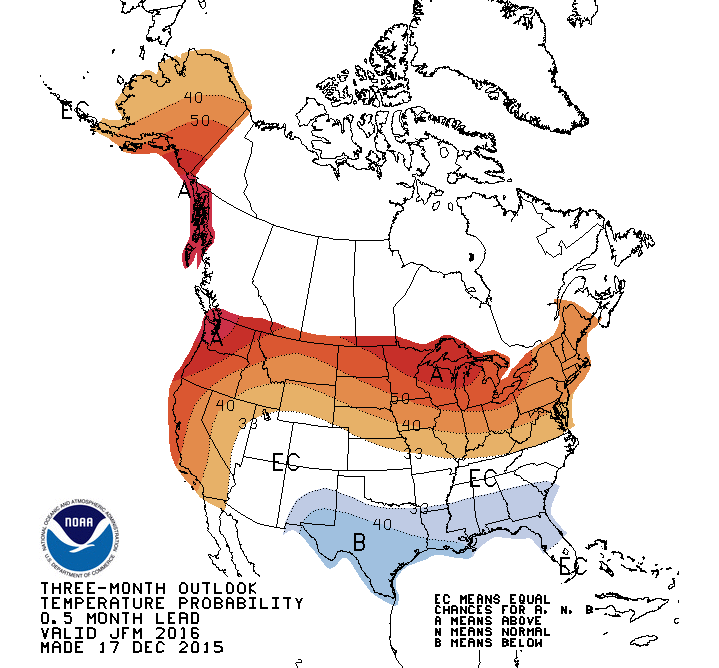 |
| Credit: CPC |
 |
| Credit: CPC |
I wish it weren't so, but it looks like the most exciting of the winter is behind us. However, I'm quite interested to see what will happen to Southern California, especially in February. They should get some tremendous drought relief, and they need water far more than we do. They could see some pretty intense storms then, but that is a month away. We will see.
Still, let's be thankful for all the great snow we've gotten so far this season! The Summit was packed today, and most people weren't even skiers or snowboarders. They were just coming up to see the snow. There were toddlers, dogs, and plenty of toboggans, and everybody looked like they were having a fantastic time.
Thanks for reading!
Charlie
No comments:
Post a Comment