8:09 pm
 |
| Visible satellite image of Hurricane Patricia at record intensity approaching the Western Mexico Coast. Taken October 23, 2015. Credit: NASA Terra/MODIS Satellite |
Patricia was the deepest cyclone ever recorded in the Western Hemisphere. Deeper than Wilma, deeper than Katrina, deeper than Camille, and far deeper than Sandy (all these storms are named after girls!). She had a central sea-level pressure of 879 hPa, beating out Wilma's 882 hPa central sea level pressure, which was the record for the Western Hemisphere at the time (and remains the record for the Atlantic Basin). These are astonishingly low pressures, and more representative of air pressure values you'd find at nearly 5,000 feet. For comparison, our August 29th summer windstorm, which knocked out power to 500,000 and killed two people, dropped to 986 hPa.
Perhaps even more impressive, however, was how quickly Patricia developed. Wilma took only 30 hours to drop from 982 hPa to 882 hPa, a 100 hPa drop. Patricia did a 100 hPa drop in 24 hours, and was nearly the fastest-developing cyclone on record. Averaged over an entire day, that's a drop of over 4 hPa an hour, and there were undoubtedly times when the rate was faster than that. For comparison, our major windstorms tend to deepen at 2-3 hPa per hour, and do not sustain that rate for very long. The only storm to ever develop faster than Hurricane Patricia was Typhoon Forrest in the Western Pacific.
But ultimately, the most impressive thing about Patricia though was her winds. Even though Patricia was an incredibly intense hurricane, Patricia wasn't all that large. Although this limited the storm surge and range of the damage, it meant that there were steeper pressure gradients within the storm, leading to higher winds. Patricia was estimated to have sustained winds of 200 mph, with higher gusts. For comparison, EF-5 tornadoes have winds of at least 200 mph. So, the strongest winds in Patricia were on par with those found in an EF-5 tornado. That is absolutely mind boggling. When it made landfall, winds were substantially lower at "only" 165 mph, but it still ended up being the most intense landfalling Pacific hurricane on record.
 |
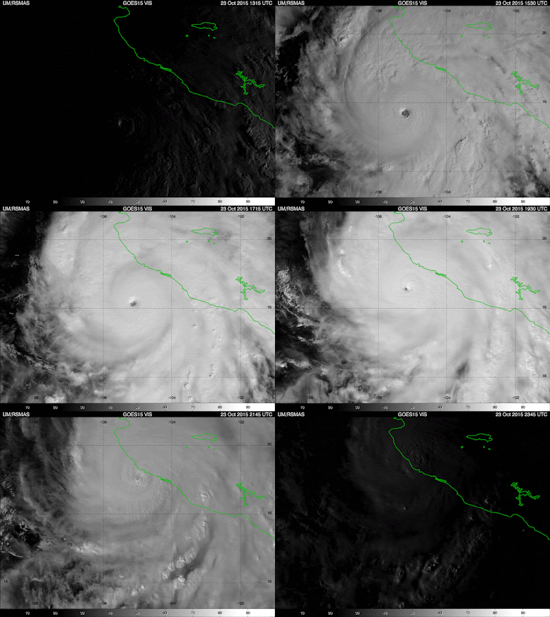
| Visible satellite loop of Hurricane Patricia approaching the Western Mexican Coast. Credit: University of Miami's Rosenstiel School of Marine and Atmospheric Science |
When Patricia was at peak strength, it had a very small eye that was approximately 8 miles in diameter. Small eyes are indicative of intense hurricanes; Hurricane Wilma's eye was only 2.3 miles in diameter, and it remains the smallest eye ever found in an Atlantic Hurricane. Patricia weakened as it went ashore due to it undergoing an eyewall replacement cycle, which is where a new eyewall forms and chokes off the old eyewall, weakening the storm (but often enlarging it in the process). The satellite loop of Wilma from NASA below shows this extremely well... note how the tiny eye eventually becomes filled with clouds and a much larger eye forms in its place.
Eyewall replacement cycles are extremely hard to predict, and as a result, while hurricane track forecasts have improved substantially over the past decade, intensity forecasts have not. On Wednesday evening, NWS models showed the storm deepening to 950 hPa. They were about 70 hPa off... not very good.
Surprisingly, Patricia did not do much damage, and only 7 deaths have been reported thus far. It ended up striking Cuixmala, a super luxurious and remote eco-resort (Bill Gates, Mick Jagger, George Lucas, and a host of others have stayed here). Cuixmala suffered heavy damages, but because of the compact nature of the storm, the two major cities in the area, Manzanillo to the south and Puerto Vallarta to the north, escaped the worst of the storm. Had Patricia made landfall on one of these cities, the damage would have been far worse.
Hurricane Patricia has been an astonishing example of how El Niño affects hurricane formation in the Pacific. During El Niño events, the greatest warm-water anomalies occur near the equator in the central-eastern Pacific, but these warm-water anomalies extend northward into the subtropics, and this, combined with weaker-than-average trade winds there, gives rise to active hurricane seasons.
 |
| Credit: NOAA Office of Satellite And Product Operations |
The picture above explains it all. You can clearly see the
blob of warm water in the tropical Pacific straddling the equator (not to be
confused with our precious "Blob" of warm water in the Eastern
Pacific that is slowly dying). However, these anomalously warm waters extend
northward across the equator into much of the Eastern Pacific. These warm
waters (as hot as 86 degrees where Patricia was forming), combined with little
wind shear and high humidity, created an exceptionally favorable environment
for Patricia to grow into a monster cyclone, and it didn't disappoint!
Patricia absolutely crushed the Pacific hurricane record for
minimum low pressure, which was previously held by Hurricane Linda in 1997 with
a central pressure of 902 hPa. As I've stated before, 1997 was the
biggest El Niño in recorded history, and the jury is out to whether this
current El Niño will surpass that one in strength. But the fact that these
two incredibly powerful hurricanes occurred on El Niño years is no coincidence.
Strong El Niños have massive impacts on weather around the world, and
Hurricane Patricia was a textbook example of that.
Charlie
No comments:
Post a Comment