Saturday, October 6, 2012
4:02 P.M.
It's been a pretty boring run, but we are approaching the end
I love running, but I absolutely hate treadmills. With a treadmill, you don't get the relaxing breeze in your face, you don't get to explore new places around the city, and you are in constant danger of slowing down a wee bit too much, falling off the treadmill, and becoming the laughing stock of all the other sad souls who are running on treadmills. Treadmills are atrocious for so many reasons. The only positive thing associated with treadmills is the 'Ok Go' "treadmill" music video, and even that is pretty boring to watch.
This weather has reminded me of a treadmill. It's the same stuff every day. We are experiencing the same lack of precipitation, the same degraded air quality because of forest fires... everything. It would be one thing if we were seeing the same cool stuff every day... that would be like swimming up-current in a beautiful, pristine river; sure you wouldn't be going anywhere, but it would still be intellectually stimulating and spiritually fulfilling. But the same boring stuff every day, hence the treadmill analogy. I will never degrade myself to buying a treadmill.
However, this metaphorical treadmill is just about dead, and when it dies, we will start to see interesting weather once again.
Let's take a look at the ole' trusty GFS Superensemble (aka: the really far range model I use when I am desperate for interesting weather to occur).
Valid 05:00 pm PDT Sat, 06 Oct 2012 - 6hr Fcst - 18z North Pacific GFS Superensemble 1000-500mb thickness, 6-hour precip
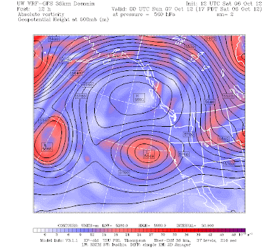
As you can see, there is still that huge fat ridge of high pressure over our area. It's massive! You can also see a very weak area of lower pressure off the coast of California. This setup is called a Rex Block, because apparently there was some guy named "Rex" who discovered it and decided to put his name on it. It's kinda hard to see in this bigger model chart, so let me show you a UW chart where it is easier to see.
Valid 05:00 pm PDT Sat, 06 Oct 2012 - 12hr Fcst - UW 12z GFS 500mb absolute vorticity, heights
It's very easy to see the Rex Block in the above chart. Here's an idealized diagram of one, just for good measure.
This thing has been here for such an infuriatingly long time, and I am ready to see it go. Will it?
The answer? YES!!! Also, no clue why, but blogger decided to highlight the back of my text white after the next sentence, and I don't know how to get rid of it.
You have to go to the very end of the latest Seattle NWS forecast discussion to get to the good part, but at the very end, they say:
 A MORE SIGNIFICANT CHANGE TO A WET WEATHER PATTERN APPEARS
  INCREASINGLY LIKELY BY LATER NEXT WEEKEND AS THE WEST COAST
  RIDGE BREAKS DOWN AND TROPICAL MOISTURE ORIGINATING IN THE WESTERN
  PACIFIC GETS ENTRAINED INTO THE WESTERLIES. ALBRECHT
I've been waiting for a sentence like this for months on end. The boredom is coming to an end. Folks, we are finally getting off the treadmill.
Valid 05:00 pm PDT Sat, 13 Oct 2012 - 180hr Fcst - UW 12z GFS 500mb absolute vorticity, heights
No more Rex Block! Surface-wise, we have a bit of precipitation coming through our area. But we gotta go to the superensemble to see any real storms affecting our area.
Valid 05:00 am PDT Sat, 13 Oct 2012 - 186hr Fcst - 18z GFS North Pacific Superensemble 1000-500mb thickness, 12-hour precipWould'ya look at that. A nice, fat, juicy front poised to strike our area. It's about time.Charlie

.gif)


No comments:
Post a Comment