Wednesday, October 27, 2010

Putting that Big Midwest Storm in Perspective

October 27, 2010
1:59 P.M.


Look at that storm!!!


Now, many of you may have heard about the huge storm in the Midwest. There has been a lot of talk about it being the strongest extratropical storm on record on the contiguous 48 states. The media generally says it is. However, many of the local weather guys around here say no. Who should you believe? Well, you should believe me, and both sides have valid points.


This storm officially has the lowest pressure ever recorded by an extratropical cyclone on the contiguous 48 states. The mercury bottomed out at 28.20" (954.9 millibars) in Bigfork, Minnesota yesterday at around 5:13 CDT. This is an official, all time record. Now, note that I respect Cliff Mass very much and regard him as a GOD, but I think he is mistaken when he says that we have had the deepest storms. We have had some very deep storms - the most recent example being a storm from December 12, 1995.  According to Wolf Read that storm probably bottomed out at 953 millibars, (see my Storm King website link - he has put together a fantastic website of historical Pacific Northwest) which is deeper than this storm, but by the time it reached land, it was above 955, and I think the lowest actual measured pressure was like 958 mb or something. So that storm is not the deepest storm to hit the continental U.S. There may be a storm back in January 1880 (which has been nicknamed "The Storm King" itself) that may have been deeper, but there is not a real official reading. So the record belongs to Bigfork. What a funny name for a town.


BUT... our windstorms are stronger than theirs by far. Why? Because our storms are more compact and have  stronger pressure gradients. Look how big the storm is in that satellite photo. The winds cover a huge area. However, since they cover such a big area, they are also less extreme. The pressure gradients drive the winds, and if the storm is bigger and the pressure gradients are more relaxed, the winds are not going to be as strong. There was an 81 mile-per-hour gust and it made national headlines. I think that's pathetic, personally. That really is not that fast. The coast sees gusts like that every winter, and even Puget Sound gets them sometimes. 


A great example to show how our storms are more compact than the ones over the rest of the nation is our "Intense Cyclone of November 3, 1958." 


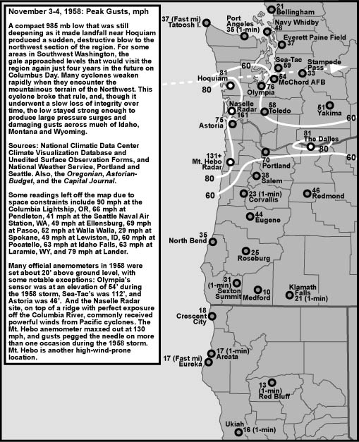
This is from Wolf Read's website. This storm was only 985 mb, yet it produced a 161 mph gust. Contrast that to a 955 mb storm that produced a 81 mph gust. This clearly shows the difference in wind velocity between the two storms. Our wind velocity is higher because this cyclone was much more compact.


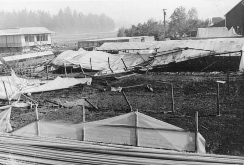
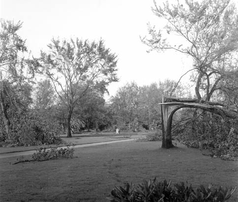
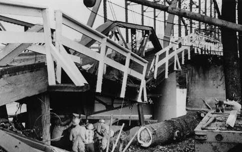
But no windstorm can even approach the Columbus Day Storm in terms of wind speeds. 


Gusts of 116 in downtown Portland, 127 in Corvallis, 160 at the Naselle Radar site (it commonly gets really windy there), 170 in the Tillamook Forest, 150 SUSTAINED at Cape Blanco with gusts to 179, or they may have been as high as 195, as one of my many weather books estimates. Renton got to 100. Newport got to 138. The list just goes on and on. THIS is the "perfect storm." Not that 1991 weak thingy. The "Perfect Storm" of 1991 had a peak gust of 85, and that was at a coastal station. There is a possible 110 mile-per-hour difference in peak wind gusts. So much for the "Perfect Storm!" When you add that on to the fact that the Pacific Northwest has tons of huge, shallow rooted trees to blow down and the Northeast has a lot less, you wonder where that storm got that name in the first place. Here are some Columbus Day photographs to give you an idea of the damage. Everything is from Wolf Read.


There is one thing that those easterners do have on us though in the "who has more gnarly extratropical cyclones" and that is severe thunderstorms. Their cyclones produce severe thunderstorms. This last one produced a little over 20 tornadoes, and although I don't think any of these tornadoes were huge, there was one storm that produced a huge tornado outbreak. April 3, 1974 was a date that will live in infamy as the largest tornado outbreak ever recorded. And these tornadoes were strong. 315 people died and over 5,000 were injured. 


Take a look at this tornado. It hit Xenia, Ohio as an F5 with estimated 300 mph winds and completely decimated the town.


So, the most damaging event was not the Columbus Day Storm or the one that we just saw over the Midwest.  It was the "Super Outbreak" of 1974! A great website to learn more about this outbreak is http://www.april31974.com/. When people talk about the strength of extra-tropical cyclones, they are generally talking about wind speed that is associated with the pressure gradients directly. In that case, the Columbus Day Storm outshines everything else by several orders of magnitude. But the Super Outbreak was a horrifically powerful weather event in a different way, and that's why I am calling it the most destructive extratropical storm the United States has seen in the last 110 years.


Oh yeah... a weather forecast.
We could see flooding next week. Stay tuned...
Charlie Phillips, over and out.

Sunday, October 24, 2010

And... Storm Season is Underway!

October 24, 2010
10:21 P.M.

I hope you guys like the new blogger template by the way. I don't care for it too much but it is a newer update so I can do more stuff, like put bigger pictures on it and stuff. I'm a fan of bigger pictures. 'merica, right? Bigger is better.

However, if you happened to be kayaking off the Washington Coast this weekend, you would probably disagree with me. The huge waves that we've been advertising for a while are hitting the beaches. These waves are not just large, they are gigantic. The average significant wave height is expected to be 33.5 feet off the coast tonight and tomorrow. As far as I can remember, there has only been one event with bigger waves, and that was when 44-foot average waves were recorded with individual heights as high as 70 feet during the December 2007 Great Coastal Gale (crazy windy on coast, not windy here, flooding everywhere). There's still a 10 foot difference in the wave heights though, which just serves to show how intense the 2007 storm was.

Snoqualmie Pass is getting a rain-snow mix, and Stevens Pass is all snow. I gotta go to bed (school tomorrow!) but we may have some more interesting weather at the end of the week. I'll keep you posted.
Charlie :)

Saturday, October 23, 2010

Big Coastal Storm on the Way!

October 23, 2010
2:01 P.M.

Many of you guys probably noticed that I didn't update the blog the last couple days. I had a ton of homework. I'm not taking the easy way out of high school, I'm taking some really advanced classes so I can get into some good colleges. Then it will be a matter of seeing how much money they give me (I don't care what college you go to, 50,000 dollars a year is a scam). But yes, we have a major storm slated for later tonight that will give the coast some huge waves, as well as giving some wind inland and some rain both in the mountains and lowlands. The Cascades could see their first significant snowfall of the season with this storm as well. First, though, let's look at the water vapor imagery to give you an idea of what is really the driving force behind this storm.

You can see the beginnings of the low-pressure system starting to form. There is a bent-back occlusion and a strong "dry slot" to the south of the center of the low. What is even more impressive to me, however, is the visible jet stream in the water vapor imagery all across the Pacific. You want to know what zonal flow is? THAT, my friends, is zonal flow. The jet stream is extremely powerful and centered right across the Pacific, and it has tapped into a ton of moisture (most of it from that big supertyphoon, Megi, which actually got down to 895 mb with 180 mph sustained winds!). Very, very impressive water vapor imagery from our satellites.

But what's the actual forecast? This graphic should sum it up.

Waves! Look at those wave heights! 40 foot waves could batter the central Washington coast! That is just astounding. I've seen higher waves (December 2007 - average recorded height at a buoy by the Columbia was 44 foot waves with individual ones as high as 70 feet before the buoy became unmoored) but these are still extraordinary wave heights. I'm trying to convince my mom to take me to La Push tomorrow to witness these waves but she says absolutely not.

Some of the coastal areas have storm warnings, Willapa Bay southward has a high-wind warning (coast only), the Skokomish River might get flooded, and the mountains even have winter storm watches! As I've been advertising for a while, the mountains above 4000 feet could get a real dose of snow. I would not be surprised if they got a foot from the highly unstable air that will be filtering in Sunday night after this big event is over. The air temperatures in the upper atmosphere will be cool enough to support snow at the higher passes. I think Snoqualmie Pass will see a rain-snow mix, but would happily be proven wrong. For those of you who ski at Alpental, the upper mountain should get a good dumping! Because of the snow, there will be no flooding concerns on the Cascades.

Sit back and enjoy the show folks! What a way to kick off the storm season!

Wednesday, October 20, 2010

Storm Details Uncertain

October 20, 2010
4:34 P.M.

The details on the storms this weekend are still very, very murky. The American models, the GFS and the NAM, have been forecasting a large low pressure system to bottom out in the Gulf of Alaska at around 950 millibars, sending a strong front right into our area. This is a very deep low, but, surprisingly, these type of events are not all that uncommon where sub-950 millibar lows intensify until they kind of stall in the Gulf of Alaska. Here is a picture of the mm5-GFS model for 5 P.M. Saturday.


It is pretty similar to what we have been seeing all along. The coast has the best chance at getting high winds with this storm, and I wouldn't be surprised to see a stray 70 mile per hour gust, especially at Tattoosh Island. Gusts inland will be in the 30-40 mile per hour range. 

Now, let's look at the Canadian model, which is showing a scenario that would give us some wind. This model takes that one big storms and splits it into two smaller storms, but they come right at us. The same sounds true with the Euro, although since I'm not in the NWS I don't really have good access to that model. Here is the 00UTC Monday map (around 4 P.M. local time I think)


As you can see there is a powerful 965 mb cyclone slamming right into us. That would give us high winds. The latest GFS also *kind of* follows this, though the storm is further north and it kind of fizzles out before hitting us, stll giving us lots of rain and wind but not windstorm-type winds. One thing is for sure - the Cascades above 4000 feet will get a LOT of snow from this storm, and I think Snoqualmie Pass will end up getting some too.

The NWS guys will be busy over the next couple days. Come to think of it, so will I. :)

Tuesday, October 19, 2010

It's Gonna Get Bad, but Where and How Stormy?

October 19, 2010
5:24 P.M.

Well, the models have been all over the place over the past few runs with what they are showing, and I know exactly why. First, the jet stream is very strong, and although models are good at picking up this pattern, they have a hard time pinning down what storms will affect which areas at which time. Often, when the models are as inconsistent as they are now, meteorologists will "broadbrush" the forecast, meaning they say it will be wet but don't give any specific details. Usually it is reserved for longer range forecasts outside of a week or so, and this storm is expected to come in Saturday night. However, due to the inconsistencies in the models, the NWS guys are just saying it is gonna be wet and giving more details later. Another reason is that the NWS confirmed that tropical moisture IS going to be entrained in this system (I called it!) from supertyphoon Megi, which once had a central pressure of 895 millibars and sustained winds of 180 miles per hour! Obviously, that powerful of a storm is going to offer some very deep tropical moisture, and just how much of it gets entrained in the jet stream is going to make a huge difference on what kind of a storm we will see. Our models generally have issues pinning down details when tropical moisture is involved.

The trend over the last few model runs has been to put the heaviest precipitation in California. We will see if this comes true. Washington will still get a good soaking though, and there could be very strong winds out on the coast and at least blustery winds inland. Here's the 24 hour precip ending at 5 P.M. Sunday. Lots of 10+ inch totals in the mountains of Northern California.


Beyond, models still show active stuff, but I'm not going to give any details because they will change. It will, however, be wet and windy. There's a broadbrush forecast!
Charlie