Well, I got pretty busy this past week and the weekend after putting off all my work to deal with that windstorm. It wasn't quite as big as I thought it was going to be, but it was still pretty windy around the area with 45-70 mph gusts throughout all of Washington and some unexpected 50 mph gusts near Portland.
If you really wanted high winds, you had to head to the mountains. Mission Ridge hit 137 mph and had gusts above 100 many times during the day. In fact, they had a 14-consecutive-hour stretch of 90+ mph gusts! White Pass hit 115, and for an 8-hour period, 7 of those hours featured gusts between 113 and 119 mph. One hour was relatively calm with a peak gust of 99 mph. More of the same was found at Crystal Mountain and Rattlesnake Ridge. Credit to Scott Sistek for neatly organizing some of these top wind speeds.
This week, we are much calmer, drier, and cooler, with a massive ridge of high pressure over the Northeast Pacific and a large trough over our region. Embedded in this larger trough is a system that is making its way into our area as we speak.
Unlike our relentless atmospheric rivers last week that brought feet of rain to the southwestern slopes of the Olympics and caused major flooding on rivers flowing off the Olympics and Central Cascades, this storm is relatively quick moving and cool, with snow levels hovering around 1,500-2,000 feet. There will be a few inches of snow in the passes, but nothing out of the ordinary for this time of the year, and we certainly won't see any river flooding!
After this cold front sweeps through tonight, cold air originating from southern British Columbia will rush through the Fraser River Valley into Western Washington. This commonly happens when we have a large ridge in the Eastern Pacific and a large trough over our region. However, the ridge in the Pacific is not nearly amplified enough, the trough over our area is not deep enough, and it is still relatively early in the season, so the air entering our region won't be as cool as it has been with some of these events in the past. Right now, we are looking at highs in the low 40s for Seattle tomorrow with cooler temperatures further north and warmer temperatures off the coast.
The reason this "Fraser River outflow" exists in the first place is because these arctic air masses are often associated with high pressure. Cold air is denser than warm air, meaning that for a given column of the atmosphere, the column with cold air will have more mass and thus exert a higher pressure on the surface below. Accordingly, high pressure often resides over the interior of British Columbia when we have these outbreaks. Wind generally flows from high to low pressure, and it accelerates at the end of gaps, meaning that places like Western Whatcom County, Lummi Island, and the San Juan Islands near Rosario Strait can get pretty blustery when we have these setups. In fact, a wind advisory is in effect for the North Interior Tuesday and Tuesday night for winds of 20-35 mph with gusts to 50 mph, and gale warnings are in effect for the Strait of Juan de Fuca and waters around the San Juan Islands.
The combination of cold air and strong winds brings the threat of low wind-chills to the North Interior. There have been far worse arctic outbreaks, with 80 mph gusts and low temperatures below 0 degrees, but still, things will feel very cold, with windchill factors in the teens and 20s for much of Tuesday and Tuesday night. Bundle up!
Tuesday night fill feature clear skies, decreasing winds, and our coldest temperatures of the year, with low temperatures in the low 30s for Seattle and in the 20s in more outlying areas. The dark asphalt in Seattle and other cities around Western Washington absorbs heat during the day and radiates it off to space at night, helping keep these cities a few degrees warmer at night than other places throughout Western Washington. Wednesday and Wednesday night will continue to be cold and clear, and temperatures will finally start to moderate for Turkey Day and the weekend (but we will still remain pretty chilly).
But what about the snow?
There was some hoopla late last week and over the weekend about a possible snow event happening Monday night into Tuesday. Right now, it doesn't look like that will happen. By the time the really cold air originating from the Fraser River Valley gets here, we will have dried out substantially, and even if we did have some precipitation in the area, it would likely be in the form of rain or a rain-snow mix, as temperatures are just not cool enough to support snow accumulation, especially in the Seattle metropolitan area. Sorry kids. The places that have the best chance of seeing some snow are the typically rainshadowed communities on the northeastern tip of the Olympic Peninsula, because now that our flow is coming from the northeast instead of the southwest, they are on the windward side of the Olympics! Still, accumulations will be negligible below 500-1000 feet.
Things are really ramping up now throughout Western Washington. The all-important PDX-BLI gradient, which was forecast to max out at 14-18 hPa, is already at 18 hPa, and continues to slowly rise. There is a chance that the gradient could reach 19 hPa at some point today. Regardless of what it reaches, today will be the windiest day of the year so far for many people in Western Washington.
However, I want to make one thing clear: this windstorm will not be on par with the Columbus Day, Inauguration Day, or Hanukkah Eve storms, which are generally regarded as the three most intense storms to hit the Puget Sound region in the last 60 years. It will be stronger in most places than the August 29th windstorm that knocked out power to 500,000 people, but because the deciduous trees have lost many of their leaves, it will not be nearly as destructive. On the other hand, soils are saturated from the recent heavy rain, particularly soils in the Cascades and Olympics, making trees more prone to toppling under high winds. Either way, at least 100,000 people will lose power, but definitely not 1,000,000.
First, let's talk about rain. Moderate rain is falling over the lowlands, and the heavy rain is falling in the mountains. Just like the event this past weekend, there is relatively little rain over the Pacific, but once that moist air encounters some terrain, rain starts pouring down. You can also see a thin line of precipitation off the coast, which marks the location of a very strong cold front. More on that later.
Here are some 24-hour totals from around the region. The area between central Whidbey Island and Seattle has been relatively shadowed from the rainfall over the past 24 hours, but as the radar image shows, Seattle is now mostly out of the rain shadow, which is mainly situated over Everett. The mountains, coast, and lowlands from Seattle south are getting the heaviest rain right now, with one gauge near Lake Quinalt on the Olympics picking up 6.40 inches! This is the same gauge that received 12 inches in 24 hours this past weekend, so it's no coincidence that it has received the heaviest rainfall thus far.
Due to all this rain, saturated soils, and the rivers already running high from last weekend, we currently have 8 flood warnings across the area. I've listed them below.
Major Flooding:
Skokomish River near Potlatch affecting Mason County
Moderate Flooding:
Snoqualmie River near Carnation affecting King County
Snoqualmie River near the Falls affecting King County
Skykomish River near Gold Bar affecting Snohomish County
Minor Flooding:
Stillaguamish River at Arlington affecting Snohomish County
Chehalis River at Porter affecting Grays Harbor County
Elwha River at McDonald Bridge affecting Clallam County
Grays River near Rosburg affecting Wahkiakum County
Now that we've got that covered, let's talk about the main story for today: wind.
It's now 11:26 at my house, and winds are really starting to pick up.
As you can see, winds are pretty gusty around Washington... we recently had a 55 mph gust at West Point in Magnolia... but nothing out of the ordinary. Most peak gusts in the lowlands thus far have been 30-50 mph. Sea-Tac has hit 40, and Everett (Paine Field) has hit 53.
I expect winds to really start ramping up by noon as the cold front associated with this storm draws closer. There will be higher pressure gradients and the atmosphere will be less stable, allowing for some of those gusty winds aloft to make it down to the surface.
520 Bridge is still open, but I think they will close soon... they are getting sustained winds of 39 mph with gusts to 47 as of 11:40. They need 15 minutes of frequent 50+ mph gusts to close.
Winds will probably peak in the Puget Sound region around 1 pm as the front passes, but high winds will continue well into the evening for those along the Strait of Juan de Fuca, particularly near the eastern entrance by Fort Ebey on Whidbey Island. A storm warning is in effect for that region calling for 40-50 knot sustained winds coming from the west. Some of these winds will make it over to Mukilteo and Everett, so they will remain windy well after Seattle had quieted down, and these westerly winds could be stronger for some areas than the southerly winds being experienced now, before the frontal passage. The Seattle City Light "WINDWATCH" (created by the University of Washington) clearly shows a strong surge of 50-60 mph gusts behind the front coming through.
One more point before I leave... the cold front with this storm is intense and has a large temperature and pressure gradient. We usually don't get intense fronts of any kind because of the moderating effects of the Pacific, but this front is worthy of special recognition. UW's ultra-high resolution 1.3 km WRF-GFS shows this well... note how the pressure drops immediately ahead of the front and sharply rises afterward. There should be strong winds and heavy rain with this feature for many areas.
It's looking more and more like a significant windstorm may be in the works. The models are not as bullish about this storm as they were yesterday morning, but they are still showing very strong winds with widespread power outages possible. Charge your devices tonight!
Water Vapor Image Taken 4 pm, Nov 17 2015. Credit: NWS
The picture above is a water vapor satellite image of the eastern Pacific and western North America. I love these things because in addition to helping you infer where clouds may be, they show how moist and dry certain areas of the atmosphere are. There are two main features here: a strong low pressure system that just made landfall near Haida Gwaii (previously known as the Queen Charlotte Islands), and that deep plume of moisture rising north from Hawaii and associated with another powerful low pressure system near 170 degrees west.
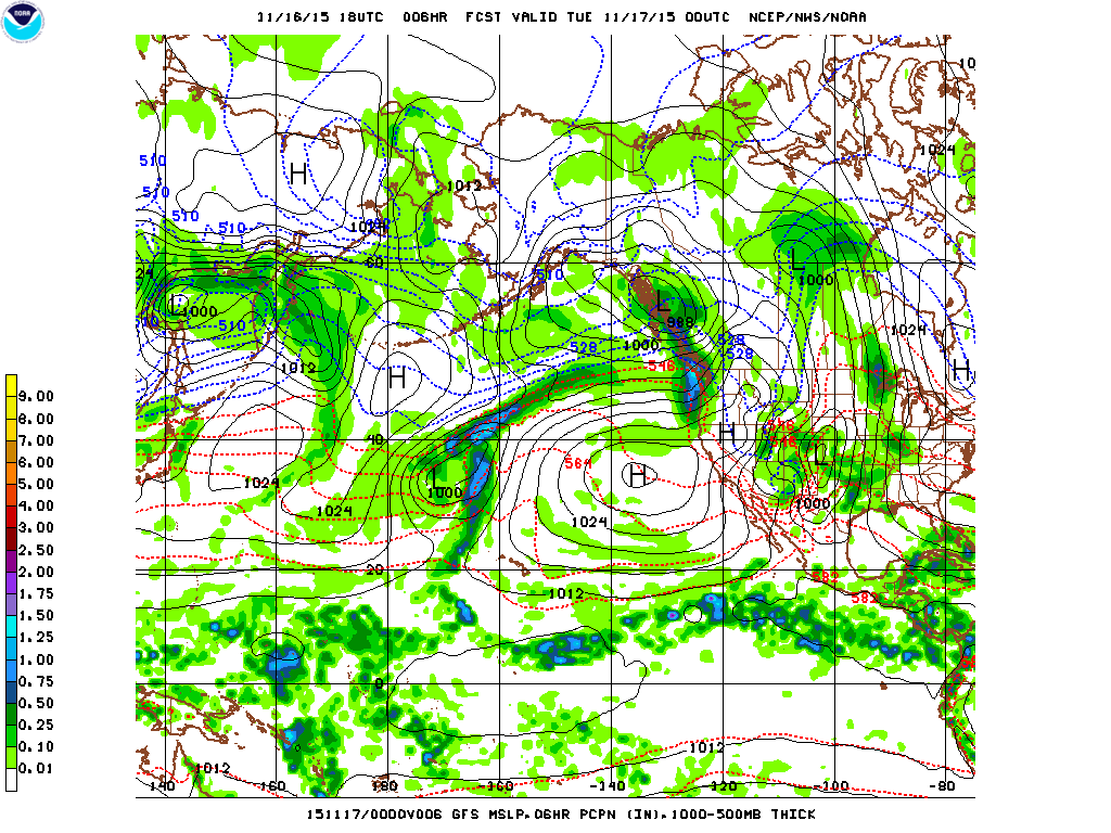
These are clearly modeled by the latest GFS model below. The shaded colors represent 6-hour precipitation, the solid black lines are sea-level-pressure, and the dotted blue and red lines are thickness contours.
What's most important about the above photograph is not the precipitation, or even the low pressure centers. The most important thing is the large gradient in thicknesses along the stream of moisture extending to the northeast from that low out in the middle of the Pacific. Thicknesses are directly related to temperature via the hypsometric equation, and the steeper the temperature gradient, the steeper the thickness gradient. The steeper the thickness gradient along a certain pressure level (for example, 500 hPa), the steeper the pressure gradient along a certain altitude (for example, 18,000 feet). Therefore, when you have a strong temperature gradient, you have large thickness gradients and a strong pressure gradient force in the upper atmosphere. The stronger the pressure gradient force, the stronger the winds, and as the chart below shows, the winds at the 300 hPa level of the atmosphere will be extremely strong. Here, they are over 150 knots... off the charts. In fact, the latest forecast discussion from the Seattle NWS office says these winds are up to 180 knots, which is truly stunning. Good for storm development, and great for airplanes going eastward across the Pacific. A Boeing 747 cruises at 570 mph, so if the pilot was feeling particularly adventurous and positioned him/herself perfectly in the jet, they could easily break the speed of sound, especially since the speed of sound is about 100 miles per hour slower at 35,000 feet than it is at sea level.
This jet will aid in the development of a compact, fast-moving, and very wet low pressure system. The system will only be around 995 hPa when it makes landfall on central/southern Vancouver Island, but depth isn't everything.
As I explained earlier, winds in the atmosphere are dependent on the pressure gradient force, or how much the pressure changes over a certain distance. There are two additional characteristics that help determine the strength of winds at the surface: (1) the stability of the atmosphere and (2) the winds aloft. We have these three things, so I'll discuss them in sequential order (with colorful pictures, of course).
Our greatest storms always have extremely high pressure gradients between Portland and Bellingham. The Portland-Bellingham (also known as PDX-BLI) gradient was a staggering 22.3 hPa back with the Hanukkah Eve Storm of 2006, good for 2nd place all-time (first place was 22.7 hPa back in October 1934). I've never been that good at counting, but the PDX-BLI gradient here looks to be around 16 hPa, which is quite strong. However, the Hanukkah Eve Storm was near 976 hPa when it crashed into the southern tip of Vancouver Island, while this storm (as shown by the 11/16/2015 12z WRF-GFS model above) makes landfall at 994 hPa on Central Vancouver Island. Given that normal sea level pressure is 1013 hPa, why does tomorrow's low generate such an intense pressure gradient?
There are two reasons: first, this low is still developing as it approaches the coast, and when lows are in this phase, they tend to be more compact and have stronger winds and pressure gradients near the center. This also means that regions further to the south - such as the Willamette Valley - will not experience major winds from this storm. Second, there is a pretty substantial high pressure system off the coast of California, which acts to create a bigger pressure change over a certain distance.
Mixing and Stability
I haven't shown the two types of charts below on my blog before, so if you've read this blog post, you have witnessed a truly historical event. Congratulations.
Most of the charts I post focus on showing what the weather is like at a specific layer of the atmosphere, whether that layer is at the surface, 500 hPa, or 5,000 feet. This chart shows the characteristics of a column of air above a certain station (Seattle) for a given period of time (in this case, 12z 11/16/2015 through 00z 11/19/2015).
Two things are quickly apparent: from 00z 11/17/2015 to 00z 11/18/2015, the air column is pretty humid all the way from the surface to 700 hPa. This means that the atmosphere is well-mixed and that air parcels in the atmosphere are moving vertically throughout the atmosphere. When one of these parcels moves from aloft to the surface, you get a big gust of wind. The large change in humidity near 18/00 represents the location of the cold front, and that is when the strongest winds will be. The tan line near the bottom shows the predicted sea-level-pressure, and you can see that it is lowest right by the cold front.
Here's a 'sounding' showing the vertical profile of the atmosphere at 1 pm tomorrow in Seattle, close to when our strongest winds are predicted to be. The blue line is the dew point, and the red line is the temperature (both in Celsius). They are virtually identical throughout the atmosphere, indicating good mixing, and they roughly follow the red dotted line, which is the moist adiabat and denotes how much a parcel cools with height when it is saturated. If the atmosphere has a lot of vertical movement and is nearly saturated, it will often cool at a rate similar to that of the moist adiabat, and that is what is happening here.
Winds aloft:
As you can see in the sounding above, the winds increase dramatically with height from 25 knots at the surface to 70+ knots at the 900 hPa layer. These winds are shown as the wind 'barbs' on the right side of the chart. Short ticks are 5 knots, long ticks are 10 knots, and triangles are 50 knots. In the sounding at 1 pm, the surface wind barb has one short tick and two long ticks, corresponding to 25 knot sustained winds. As previously stated, due to the atmosphere being well-mixed, those fast winds aloft will be able to make it down to the surface on occasion, resulting in high gusts.
Bottom line:
We will have a variety of factors working in our favor to create high winds throughout Western Washington. I'll be posting details throughout the night on my Facebook Page. Our winds will be strongest around noon or just after, and I think we will experience peak sustained winds of 25-35 mph. Most gusts will be below 60, but some places on the coast may see gusts in the 70s, and a few isolated mountain ridgetops could hit 100 (they might not have weather stations though). There will be flooding on many rivers due to the heavy rain associated with this system, but Seattle will mainly be rainshadowed by the Olympics and won't pick up too much precipitation.
Time to eat dinner! I have a life to attend!
Charlie
First off, the rain has died down around Western Washington and most rivers have receded below flood stage. The Snohomish River at Snohomish, The Skokomish River near Potlatch, and the Chehalis River at Grand Mound are still above flood stage, with minor flooding occurring. Although the rivers have already crested at Snohomish and Potlatch, the Chehalis at Grand Mound is actually still cresting. This is because the Chehalis is a big, slow river, so floodwaters take a while to reach areas downstream. The Chehalis will crest this afternoon and fall below flood stage midday tomorrow, the Snohomish will fall below flood stage any minute now, and the Skokomish will fall below flood stage this evening. Minor flooding is occurring on all these rivers.
We also saw some snow this morning in the South Sound and foothills. Even places near sea level on the northeastern Olympic Peninsula saw snow. When was the last time we had lowland snow and river flooding at the same time? I don't know, but I can't remember any. It's still pretty early in the season, but not too early to get snow; in fact, mid-November 1955 was one of the coldest stretches on record for Seattle. Today's record low was 6 degrees at Sea-Tac airport, set back in that fateful year, which was also the snowiest on record for Snoqualmie Pass. They got 828 inches from 1955-1956. That sounds like a snow total you'd expect at Mt. Baker during a strong La Niña year! Check out this video of snow this morning in Auburn!
While it's cool to talk about snow and rain, we have a much more important issue to talk about: the potential for a damaging, region-wide windstorm on Tuesday.
This is a pretty difficult forecast, particularly because there is a large spread in the models and they just started showing serious wind within the past couple runs. However, more and more are jumping on board with the idea of having a major windstorm on Tuesday. Additionally, there seems to be a lot of spread in the forecasters themselves, with the guys at the Seattle National Weather Service office mentioning the possibility for a serious windstorm while those at the Portland NWS office don't make any mention of it at all.
First, let's take a look at some excerpts from the NWS Seattle forecast discussions. You can really see how they are getting more and more concerned about the threat of a windstorm. I've put some of the highlights in bold.
Last night, 10:08 pm
A STRONG JET WILL REMAIN AIMED AT THE PACIFIC NORTHWEST MON NIGHT
  THROUGH WED. MOST MODELS SHOWED A DEEPENING LOW MOVING NORTH
  ACROSS SOUTHERN BRITISH COLUMBIA ON TUESDAY. THIS COULD BRING
  STRONGER WINDS TO THE PUGET SOUND REGION...THOUGH LIKELY BELOW
  WARNING CRITERIA. SUBSEQUENT MODEL RUNS WILL NEED TO BE EVALUATED
  IN CASE A HIGH WIND WATCH MAY BE NEEDED FOR PARTS OF THE CWA FOR
  TUE. MERCER/05
Early this morning, 4:02 am.
I FIND TUESDAY TO BE THE MOST ALARMING PART OF THE
  FORECAST...MAINLY DUE TO WIND CONCERNS. THE 00Z GFS AND ECMWF ARE
  IN GOOD AGREEMENT WITH BRINGING A DEEPENING SURFACE LOW QUICKLY
  EAST ACROSS SOUTHERN B.C. ON TUE. THE 00Z NAM WAS WEAK AND
  UNIMPRESSIVE WITH THIS FEATURE...BUT THE 06Z NAM IS TRENDING IN
  TOWARD THIS SOLUTION TOO. THE 06Z GFS IS EVEN STRONGER AND MORE
  PRONOUNCED WITH THIS FEATURE. A SHARP COLD FRONT WILL FOLLOW THE
  LOW...DROPPING IN FROM THE N-NW ON TUE AFTN. THE FRONT WILL BE
  PRECEDED BY A FEW HOURS OF INTENSE PRECIP...BUT THE SHORT DURATION
  OF JUST A FEW HOURS WILL LIMIT THE HYDROLOGIC EFFECTS. HOWEVER
  REGARDING WIND...AS THE SURFACE LOW OVER B.C. DEEPENS INTO THE
  980-990 MB RANGE ON TUE AFTN...AND PRECEDING THE COLD FRONTAL
  PASSAGE...S-SW PRESSURE GRADIENTS REALLY PICK UP...AND WINDS ALOFT
  INCREASE TO IMPRESSIVE LEVELS. THE MOST BULLISH OF THE
  MODELS...THE 06Z GFS...BRINGS THE OLM-BLI PRESSURE GRADIENT TO
  +12.8 MB AT 21Z TUE...WITH THE UIL-BLI GRADIENT PEAKING NEAR +5.3
  MB AT 00Z TUE AFTN. IN ADDITION...THE RELATIVELY BEARISH 06Z NAM
  BRINGS LARGE SWATH OF SWLY 925 MB WINDS OF 50-60 KT THROUGH THE
  STRAIT AND THROUGH SOUTH AND CENTRAL PUGET SOUND. MEANWHILE...THE
  MORE BULLISH 06Z GFS BRINGS 925 MB WINDS OF 60-70 KT...JUST AS THE
  COLD ADVECTION IS ABOUT TO SET IN. COLD ADVECTION IS
  NOTEWORTHY...BECAUSE IT HELPS TO MIX THE ATMOSPHERE THROUGH A
  GREATER DEPTH AND PULL DOWN STRONGER WINDS ALOFT. STATISTICAL
  GUIDANCE IS ALSO IMPRESSIVE. THE 06Z GFS-BASED MOS GUIDANCE FOR
  SEA-TAC PEAKS THE SUSTAINED WIND AT 37 KNOTS...WHILE THE GFS-BASED
  MARINE MOS GUIDANCE SHOWS AN IMPRESSIVE AND ALARMING 48 KT
  SUSTAINED AT WESTPOINT...WHICH IS AT THE TIP OF SEATTLE`S
  DISCOVERY PARK. BOTTOM LINE IS TO CHECK BACK TO SEE IF LATER MODEL
  RUNS ARE STILL STRAYING THIS WAY. IF THERE IS GOOD NEWS...IT IS
  THAT THE TRACK OF THE LOW COULD SUPPORT A LULL OR SUCKER HOLE IN
  THE WIND DOWNWIND OF THE OLYMPICS. STRONGEST WINDS IN THIS PATTERN
  WOULD BE IN LOCATIONS OPEN TO THE STRAIT OF JUAN DE FUCA...AND
  LOCATIONS SOUTH OF DOWNTOWN SEATTLE. DUE TO THIS EVENT STILL BEING
  60 HOURS OUT...WILL SAVE DECISIONS ON A HIGH WIND WATCH FOR THE
  DAY SHIFT.HANER
Later this morning, 10:30 am:
THE 12Z NAM12 AND GFS20 SOLUTIONS CONTINUE TO SHOW THE DEVELOPMENT
  OF A WAVE ON THE JET THAT RIDES EASTWARD ACROSS ABOUT THE NORTHERN
  TIP OF VANCOUVER ISLAND AND INTO ALBERTA. THE FAST MOVING WAVE WILL
  BE DEVELOPING AS IT MOVES EAST. A QUICK LOOK AT THE 12Z ECMWF SHOWS
  THE WAVE DEVELOPMENT A BIT FARTHER SOUTH SUGGESTING THAT LOW
  PRESSURE MAY RIDE EAST ALONG THE CANADIAN BORDER ON TUESDAY INSTEAD
  OF ABOUT 100-200 MILES (to the north). IN ADDITION TO PRODUCING A PERIOD OF INTENSE
  RAINFALL ON TUESDAY WITH IMPRESSIVE AMOUNTS SHOWN IN THE MODELS FOR
  THE WEST FACING SLOPES OF THE CASCADES AND OLYMPICS...WIND IS
  BECOMING AN INCREASING CONCERN. 925 MB WINDS TO THE SOUTH OF THE
  FRONT RISE TO AROUND 70 KT AS THE WAVE MOVES BY TO THE NORTH AND MOS
  VALUES FOR SEATTLE SHOW IMPRESSIVE 34 KT SUSTAINED WIND FOR 2 3 HOUR
  PERIODS. GRADIENTS AND WINDS ALOFT SUPPORT RATHER WIDESPREAD SOUTH
  TO SOUTHWEST WIND AHEAD OF THE FRONT OF 40 MPH WITH GUSTS TO 70 MPH.
  THEN...WESTERLY WINDS THROUGH THE STRAIT OF JUAN DE FUCA COULD
  IMPACT AREAS ON THE EAST SIDE OF THE STRAIT LIGHT WHIDBEY ISLAND AND
  POSSIBLY THE NORTHERN HALF OF SNOHOMISH COUNTY. WILL LIKELY NEED TO
  ISSUE A HIGH WIND WATCH FOR TUESDAY INTO TUESDAY EVENING FOR MUCH IF
  NOT ALL OF THE FORECAST AREA WITH THE AFTERNOON PACKAGE.
So, in the space of 12 hours, the forecasters went from 'could bring stronger winds to the Puget Sound but likely below warning criteria' to 'sustained winds of 40 mph with gusts to 70' and saying we will probably need a high wind watch for everywhere in Western Washington. Big change, huh?
So that's the National Weather Service. Here's my forecast.
The most recent 18z NAM and GFS runs came out, and they are weaker than the previous runs. The GFS could still give us a high-wind-warning, but we wouldn't see gusts to 70 with sustained winds of 40. Still, I expect that the models will wobble around a lot before finally settling on a solution. And remember, the 12z European model put the low into central/southern Vancouver Island, which would likely give us even larger wind. I have limited access to the 'Euro,' so I don't know the specifics, but it looks very windy. Also, keep in mind that the 06z and 18z runs are generally not as reliable as the 00z and 12z runs, and this is because the 00z and 12z runs have more upper air observations.
The reason that these models are having such a tough handle on this system is because of the extremely strong jet stream driving it. Currently, there is an area of 170 knot winds up at the 300 hPa level (around 30,000 feet) driving west, and these winds will help power the storm and will reach our area by Tuesday.
The chart above shows the 500 hPa geopotential heights (contours) and absolute vorticity (colors). Don't worry about the vorticity for now... even after all these years, I still don't fully grasp it. The geopotential heights represent the elevation of the atmosphere at which the given pressure level exists. For example, that high pressure system well of the California coast has a height of 5909 meters, while the low pressure to its northwest has a height of 5498 meters.
The important thing about this chart, however, is how close together the height lines are in our neck of the woods. The closer together the height lines, the faster the upper-level winds are.
Diagram of geostrophic flow in the Northern Hemisphere. Credit: Hong Kong Observatory
In the upper atmosphere, there are two main forces acting on the velocity of these winds: the pressure gradient force (PGF) and the Coriolis force. The PGF points from high to low pressure, while the Coriolis force is always to the right of the flow in the Northern Hemisphere (and the left of the flow in the Southern Hemisphere). Eventually, the two forces reach a balance, and the winds blow completely parallel to the height/pressure lines (it doesn't matter what coordinate you use in the vertical, as you get the same result). The resulting flow is said to be geostrophic.
We know that this jet stream will be in our neck of the woods. However, we don't have a good handle on whether it will result in a major windstorm for us.
Now, let's take a look at some other maps closer to the surface.
Here is a map of the forecast winds at 925 hPa level on Tuesday afternoon. This was taken from the 06z GFS, with some annotations added by the NWS.
These are extremely strong 925 hPa winds. The last time I remember seeing something this strong was during the Great Coastal Gale of 2007, and while we've probably had instances since then of equal or higher 925 hPa winds, we haven't had many. The reason this is important is because these winds can easily get mixed down to the surface when the atmosphere is unstable. As these winds come in, cold advection (cold air moving into the region) will occur, mixing the atmosphere and helping bring some of this energy down to the surface. The mixing of winds from the upper atmosphere to the surface is what causes our wind gusts, so the NWS forecasters are worried about high wind gusts - and rightly so.
Strong winds aloft are correlated with strong pressure gradients, but those pressure gradients are often associated with temperature gradients. This storm looks to have one of the most well-defined warm fronts I've seen on any storm system, not just here in the Pacific Northwest. And that's saying something, because due to the moderating effects of the Pacific Ocean, our fronts (both warm and cold) are usually pretty weak.
However, the warm front (east of the main low) above is incredibly strong. Note how abruptly the winds shift from weak northerly to strong westerly. The cold front looks just as strong. Warm front passages are generally pretty nonchalant. It will be interesting to look at some of the buoys off the coast and see what they measure with this front.
Here's another picture of the front, showing sea level pressure (SLP), winds at the surface, and temperature at the surface.
Finally, although wind will be the main story of this storm, it will bring heavy rain as well, particularly to the mountains. The Seattle-Everett corridor will be shadowed, with the greatest shadowing occurring on the Northern Kitsap Peninsula. Places like Poulsbo and Kingston could see less than a tenth of an inch of rain, while exceptionally orographically favorable places on the Olympics and Cascades could see over 10 inches.
Freezing levels will be high - around 7-8000 feet, and this will lead to additional flooding concerns on rivers. Pretty much all the rivers in Western Washington are still running very high from the heavy rains this past weekend, and as I previously mentioned, some are still flooding. Because of that, this flooding could be worse than the flooding we saw this past weekend.
By the way, the National Weather Service Seattle office just issued a high wind watch for the entire Western Washington lowlands from Tuesday through Tuesday evening, calling for gusts of up to 75 mph and the threat of large tree failures due to the recent heavy rainfall. The highest gusts will likely be in the most exposed places (Naselle Ridge, Destruction Island, etc.) but I would not be surprised if Sea-Tac hit 60 from this event.
There is considerable uncertainty with this event, so please keep that in mind. But one thing's for sure: when the Seattle NWS homepage looks like this, it's a fun time to be a weather nerd!
Credit: PRISM Group and Oregon Climate Service. Retrieved from Reddit (yup!)
One of the most fascinating things about Pacific Northwest weather is how much our local terrain influences our climate. Just in the state of Washington, we have two mountain ranges that get gobs of snow, a massive ocean off our coast, an inland sea, a temperate rainforest, a desert, and everything in between. This event has been a great example of how terrain affects rainfall, as different parts of the state have gotten drastically different rainfall totals from this prolonged atmospheric river event.
So far, the wettest places have been in on the southwest slopes of the Olympics, and the driest places have been just to the south of Everett (the lack of color up north near Camano Island is due to the radar being located right there... same with the Langley Hill radar just northwest of Aberdeen). Of course, if you want to get away from the rain completely, head over to eastern Washington. Many places there have gotten zilch.
One site near Lake Quinalt on the Olympic Peninsula (specifically, USCRN site QTCW1) has experienced over 11 inches of rain in the last 24 hours. Meanwhile, folks near Everett have experienced just over a tenth of an inch of rain. In other words, some spots on the Olympics have gotten 100 times as much rain as places 80 miles to the ENE. And the sole reason for this is the Olympic mountains. It's truly mind boggling. A tenth of an inch of rain is enough to make sidewalks wet, and maybe create a puddle or two. Eleven inches will cause major flooding, and already has on the Skokomish River.
Seattle has also been firmly under the influence of this rain shadow. Many places in Seattle have only gotten half an inch of rain or so, while places near Sea-Tac have picked up twice that. The rainshadow was particularly present last night, as this WeatherOn radar image shows.
This leads us to the age-old Western Washington forecasting dilemma: how do you explain that some locations will get major flooding, while still telling people that they'll likely stay dry?
From what I've noticed, nobody seems to talk about rainshadows beforehand. I didn't mention it at all in my previous blog post (even when I knew it was going to happen), the Seattle National Weather Service office didn't explicitly mention it in any of their forecast discussions, the news stations didn't write about it on their website (with the exception of Q13 Fox, who inferred it on their site but never actually used the word "rainshadow" or any derivations of it). I didn't watch the news segments, so it is likely that the weathermen explained the rain shadowing effect when they pulled up animations of the radar, but fewer people watch the news these days and instead get their news from smart phones and other portable electronic devices, so this is something that should have been highlighted online. Cliff Mass blogged about it, but not during his forecast before the storm... only after the rainshadow became apparent on radar. Cliff doesn't have any obligation to forecast for the public - he goes out of his way to write a blog because he loves sharing his knowledge of weather and climate (among other things) with the public, but the news stations and NWS do.
If we don't explicitly explain to people in the Puget Sound lowlands that they will get significantly less rain due to the rainshadowing effects of the Olympics, we have not done our job as forecasters. I'm not blaming anybody here, especially because I did the exact same thing. But it is a wake-up call.