Friday, January 27, 2012
10:05 P.M.
Hey everybody, I'm just writing this to let you all know that I am still updating my blog from time to time! However, I'm swamped with work right now, so don't fret if you don't see many posts in the next week (or two). I'll still post occasionally.
Thanks!
Charlie
Friday, January 27, 2012


Thursday, January 19, 2012
Snow Update
Thursday, January 19,


5:20 P.M.
Hi everybody, this is just a quick update... the snow has stuck around longer than forecast, and freezing rain has mainly impacted areas south of Seattle, sparing the Seattle area itself. The snow has been going on all day here, and I'd say UW got about 2 inches out of this storm, maybe a little more.
I'm actually expecting another inch or two before we are done, as the precipitation, after briefly dipping south, is starting to rise back up north again. Temperatures have been below freezing all day here, and I doubt they will warm up significantly overnight. Friday morning should see a significant warm up, but temperatures may very well not get above freezing in some spots until daybreak. If this pans out, schools will likely be canceled.

05:25pm PST Wed 19 Jan 2012
One thing that makes me think that the cold air may stay around longer is the fact that both the surface temperatures and temperatures aloft are decreasing. Take a look at the latest profiler from Sand Point. This graphic shows the temperatures recorded throughout the atmosphere at different times of the day. As you can see, the air aloft is much warmer than the air at the surface due to relatively warm and moist Pacific air over-running the colder, drier, arctic air below. Still, the most recent sounding, the black one, is noticeably cooler aloft than the other soundings today.

Even though the event is not over, it'd be great to have some more preliminary snow totals!!!
Thanks,
Charlie
Ice Storm Warning
Thursday, January 19, 2012
11:06 A.M.
As if snow wasn't bad enough...
After the major snowstorm yesterday, another storm was forecast, but precipitation was only supposed to make it to Olympia. The models turned out being wrong with this storm, and precipitation is located all the way to the eastern entrance to the Strait of Juan De Fuca.

The upper atmosphere has warmed up significantly since yesterday morning, particularly south of Seattle, yet the lower atmosphere has largely remained below freezing. This type of setup can create freezing rain, which is more disruptive and hazardous to the region than snow. Snow can make the roads very slick, but freezing rain turns them into an ice rink.

Many places south of Seattle are reporting freezing rain right now, and the NWS has issued an ice storm morning for much of the Puget Sound region and southwestern Washington. This is the first ice storm warning issued since 1996, where Seattle got 2 feet of snow before everything first changed to freezing rain, and then rain. While this storm is not expected to have as much of an impact on the region as the December 1996 one, it will be very disruptive to the region. Ice not only creates slick roads, it accumulates on trees and power lines, bringing them down and causing power outages. Many places have reported over a half-inch of ice so far. Let's take a look at some pictures from around the region!


11:06 A.M.
As if snow wasn't bad enough...
After the major snowstorm yesterday, another storm was forecast, but precipitation was only supposed to make it to Olympia. The models turned out being wrong with this storm, and precipitation is located all the way to the eastern entrance to the Strait of Juan De Fuca.

11:22am PST, Thu 19 Jan 2012
The upper atmosphere has warmed up significantly since yesterday morning, particularly south of Seattle, yet the lower atmosphere has largely remained below freezing. This type of setup can create freezing rain, which is more disruptive and hazardous to the region than snow. Snow can make the roads very slick, but freezing rain turns them into an ice rink.

Many places south of Seattle are reporting freezing rain right now, and the NWS has issued an ice storm morning for much of the Puget Sound region and southwestern Washington. This is the first ice storm warning issued since 1996, where Seattle got 2 feet of snow before everything first changed to freezing rain, and then rain. While this storm is not expected to have as much of an impact on the region as the December 1996 one, it will be very disruptive to the region. Ice not only creates slick roads, it accumulates on trees and power lines, bringing them down and causing power outages. Many places have reported over a half-inch of ice so far. Let's take a look at some pictures from around the region!

Kent, Washington - Photo Credit - Kristen Jordan

Issaquah, Washington - Photo Credit - Stephanie Schlosser

Auburn, Washington - Photo Credit - Mark Haley

Auburn, Washington - Photo Credit - Mark Haley

Auburn, Washington - Photo Credit - Mark Haley
However, there is some good news. At the UW campus, the freezing rain has changed to a steady, accumulating snow. It looks like the snow may extend a bit further south than the NWS was expecting it to at this point, so places Seattle north could easily see up to two additional inches if it keeps snowing, with no changeover to freezing rain or rain.
Things should gradually warm up a bit overnight, and they will really warm up Friday. On an interesting note, some of the models have been indicating a change to colder weather in "la-la land" on the models (so far out that you can't put much stock in the results) but it is at the very least interesting to see. I will keep you updated if the arctic outbreak looks more likely.
Thanks for reading! Stay safe out there.
Charlie
Wednesday, January 18, 2012
Post Your Snow Totals!!!
Wednesday, January 18, 2012
9:50 A.M.
Hello everybody! It snowed last night and most places in Washington are still seeing snow right now! The models this morning actually came more in line with what I was predicting last night and are now predicting more snow for the Puget Sound lowlands. A couple more inches will fall in the Puget Sound region today before the snow tapers off this afternoon. It will remain below freezing today and overnight, so much of the snow on the roads right now will stay there through Thursday. Schools will likely be closed tomorrow.


I've heard of some preliminary snow totals, and as expected, the heaviest snow was in southwest Washington. Toutle got 18 inches, Centralia got 17 inches, Winlock got 15 inches... incredible stuff. In addition, winds gusted at over 100mph on the Oregon Coast last night.
Seattle might not have gotten the brunt of the storm, but we got a pretty good amount, and I'm content with that. Now, I'm gonna go play in it!
PLEASE post your snow totals, along with your elevation and location, on the comments down below!!!
Enjoy the snow,
Charlie
9:50 A.M.
Hello everybody! It snowed last night and most places in Washington are still seeing snow right now! The models this morning actually came more in line with what I was predicting last night and are now predicting more snow for the Puget Sound lowlands. A couple more inches will fall in the Puget Sound region today before the snow tapers off this afternoon. It will remain below freezing today and overnight, so much of the snow on the roads right now will stay there through Thursday. Schools will likely be closed tomorrow.

Valid 04:00 am PST Thu, 19 Jan 2012 - 24hr Fcst - UW 4km 12z 1/18/2012 WRF-GFS - 24 hour snowfall
Olympia got HAMMERED with this storm... my roommate is from Olympia and one of his friends is reporting 13 inches of snow. Warning: everybody who's not in Olympia will be pretty jealous...

Photo credit: Dylan Glebe
Below are observations over Washington as of 9:53 A.M. Nearly all places are seeing NE winds with the exception of southern Washington, where the winds are from the SE. The "rain" is posted on the right, but all of it has been in the form of snow save perhaps Vancouver, Washington, which is right by the border.

Seattle might not have gotten the brunt of the storm, but we got a pretty good amount, and I'm content with that. Now, I'm gonna go play in it!
PLEASE post your snow totals, along with your elevation and location, on the comments down below!!!
Enjoy the snow,
Charlie
Tuesday, January 17, 2012
Models Pessimistic, Charlie Optimistic
Tuesday, January 17, 2012
10:05 P.M.
So, the latest model runs have come in, and they are moving the storm even further south. For snow lovers who live in Seattle, this is bad news. However, I've been watching the radar, and I believe that we will see more snow than is currently forecast by the models. I'm still expecting less than 4 inches north of Seattle, 4-7 inches from Tacoma to Seattle, and over 7 inches south of Tacoma, despite the fact that the newest WRF-GFS model gives Everett to Tacoma a paltry 1-3 inches of snow. The southern Cascades in southern Washington and northern Oregon will receive feet of snow with this storm, so if you are bummed out that we didn't end up getting one of the biggest snowfall events in years around here, just head to the mountains. You can be standing in feet of snow, maybe bring a picture of the Space Needle along with you, and you can at least pretend that Seattle is experiencing a true "Snowmageddon."
Many of you are probably frustrated with how the forecasts have changed so much, particularly how they have gone back down after first proclaiming that Seattle would be in for the snow event of a lifetime. I'm not sure if these next few images will calm your nerves or just get you angry at our weather models, but I think it is important for the populace to understand how much a situation can change in such a short amount of time.
Let's take a look at the progression of this event on the UW WRF-GFS model. Here, I am showing the different 24-hour snowfall forecast maps starting from when the event was 84 hours out and ending with the current snowfall forecast over our area over the next 24 hours.
Things were starting to look interesting on Sunday morning's run. At first, the models showed the low coming north, quickly scouring out any cold air but also dumping several inches in northern spots like Bellingham.

Sunday night? uh oh, major snow. Still a lot of snow to our north.

Then comes Monday morning's run. Close to a foot over Seattle. Simply amazing.

Monday night's run was very different, but it still suggested a lot of snow for Seattle. This was probably our worst-case scenario. The low was shown to go to our south, bringing down cold air, yet still be close enough to give lots of snow to Seattle. Honestly, this was when I started freaking out. A major snowstorm, possibly the biggest since 1996 in Seattle, and maybe before that for Sea-Tac.




10:05 P.M.
So, the latest model runs have come in, and they are moving the storm even further south. For snow lovers who live in Seattle, this is bad news. However, I've been watching the radar, and I believe that we will see more snow than is currently forecast by the models. I'm still expecting less than 4 inches north of Seattle, 4-7 inches from Tacoma to Seattle, and over 7 inches south of Tacoma, despite the fact that the newest WRF-GFS model gives Everett to Tacoma a paltry 1-3 inches of snow. The southern Cascades in southern Washington and northern Oregon will receive feet of snow with this storm, so if you are bummed out that we didn't end up getting one of the biggest snowfall events in years around here, just head to the mountains. You can be standing in feet of snow, maybe bring a picture of the Space Needle along with you, and you can at least pretend that Seattle is experiencing a true "Snowmageddon."
Many of you are probably frustrated with how the forecasts have changed so much, particularly how they have gone back down after first proclaiming that Seattle would be in for the snow event of a lifetime. I'm not sure if these next few images will calm your nerves or just get you angry at our weather models, but I think it is important for the populace to understand how much a situation can change in such a short amount of time.
Let's take a look at the progression of this event on the UW WRF-GFS model. Here, I am showing the different 24-hour snowfall forecast maps starting from when the event was 84 hours out and ending with the current snowfall forecast over our area over the next 24 hours.
Things were starting to look interesting on Sunday morning's run. At first, the models showed the low coming north, quickly scouring out any cold air but also dumping several inches in northern spots like Bellingham.

Valid 04:00 pm PST Wed, 18 Jan 2012 - 84hr Fcst - UW 12km 24 hour snowfall - initialized 12z Sun, 15 Jan 2012
Sunday night? uh oh, major snow. Still a lot of snow to our north.

Valid 04:00 pm PST Wed, 18 Jan 2012 - 72hr Fcst - UW 12km 24 hour snowfall - initialized 00z Mon, 16 Jan 2012
Then comes Monday morning's run. Close to a foot over Seattle. Simply amazing.

Valid 04:00 pm PST Wed, 18 Jan 2012 - 60hr Fcst - UW 12km 24 hour snowfall - initialized 12z Mon, 16 Jan 2012
Monday night's run was very different, but it still suggested a lot of snow for Seattle. This was probably our worst-case scenario. The low was shown to go to our south, bringing down cold air, yet still be close enough to give lots of snow to Seattle. Honestly, this was when I started freaking out. A major snowstorm, possibly the biggest since 1996 in Seattle, and maybe before that for Sea-Tac.

Valid 04:00 pm PST Wed, 18 Jan 2012 - 48hr Fcst - UW 12km 24 hour snowfall - initialized 00z Tue, 17 Jan 2012
Then came this morning's run. A major letdown. All of the heavy snow has moved to our south. Still, we had pretty significant amounts nonetheless... I'd take 2-6 inches any day!

Valid 04:00 pm PST Wed, 18 Jan 2012 - 36hr Fcst - UW 12km 24 hour snowfall - initialized 12z Tue, 17 Jan 2012
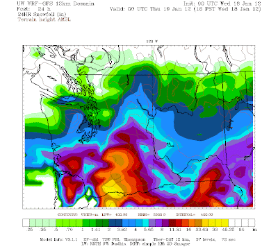
Tonight's run was a crusher though... the snow has moved even further south!

Valid 04:00 pm PST Wed, 18 Jan 2012 - 24hr Fcst - UW 12km 24 hour snowfall - initialized 00z Wed, 17 Jan 2012
And that's the evolution of our snowstorm prediction. Looking at last night's model run, it's easy to get pretty excited, but the models had a poor handling on this storm and are now giving us paltry amounts as compared to what they were showing before.
Forecast models are our best tool of predicting weather in the future, and model predictions will get better in the future around here, especially as ensemble forecasting continues to be developed. Still, models are models. Let's take a look at what is actually happening out there!!!

Valid 10:47pm PST Wed, 18 Jan 2012
We've got a FAT blob of moisture headed up our way from the southwest, and the good thing is that it is looking more impressive here than it did on our models. Ever since the two WRF-GFS runs today, I've been thinking that the models have been underestimating the strength of the jet stream propelling this thing into our area. You can see some heavier precip around the edge of the front, and if I had to guess why these features are there, I'd say it is because the warm air is rising over the cold wedge of air that I was showing to you in the cross-section diagrams of my previous post. It's a great thing to see, and I'm very happy that the precipitation is this far north this early. The mark of a really good forecaster is the ability to pin down amounts in the short term when models are of little use just by looking at radar imagery. By looking at this radar image, I'd expect snowfall amounts exceeding those shown in the WRF-GFS above, which is why I have forecast 4-7 inches of snow from Everett to Tacoma. Taken at face value, the WRF-GFS shows anywhere from 1-3 inches from Everett to Tacoma.
Now, let's take a look at the bigger picture.
I'm going to show three different images here from different times throughout the day. These images show the water vapor in the atmosphere, which is often more useful than standard infrared satellite maps for picking out centers of low pressure, as low pressure centers tend to develop a "dry slot" right by the low as they develop.

01:00 pm PST Tue 17 Jan 2012
This image was taken at 1 P.M. this afternoon. That huge blob of moisture is what is headed towards us.

06:00 pm PST Tue 17 Jan 2012
5 hours later, the front is moving in. Notice how defined the leading edge has become as it has moved into our area. Again, I am hypothesizing that the reason for this increase in definition is because of the warm, moist air riding above the cold wedge of arctic air extending back into Canada. I've only taken atmos 101 though, so don't quote me on that.
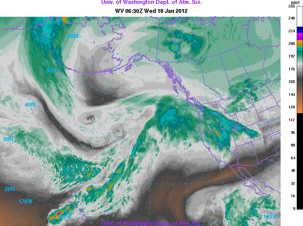
10:30 pm PST Tue 17 Jan 2012
Now, the high level clouds are completely over our area, and we are just waiting for the surface precipitation to catch up! In case you didn't catch on, this system is moving pretty dang fast, being driven by a very strong jet stream aloft.
Let's go over some quick gradients and surface observations now, and then I gotta get out of here!!!
These gradients were given to me by my friend and fellow weather nerd Nicholas Efthimiadis.
The BLI (Bellingham) to YWL (Kelowna) gradient is currently -10.7, meaning the pressure in Bellingham is 10.7 degrees lower than the pressure in Kelowna. Remember, wind always flows from high pressure to low pressure, and over terrain, it follows a fairly direct, "as-the-crow-flies" path. Hence, tons of frigid air is making it's way from the interior of BC to Bellingham. Indeed, the last time I checked, the temperature at the Bellingham airport was 11 degrees Fahrenheit. Cold stuff!
The OLM (Olympia) to BLI (still Bellingham!) gradient is currently -1, meaning that Western Washington is now experiencing light northerly winds. Expect those to become pretty strong tomorrow, especially up by Bellingham.
Now, the surface observations in our state as of 11 P.M.

11 degrees, clear, and light (~5mph) winds out of the NNW at BLI, with temperatures slightly above freezing at Sea-Tac. Right now, the Willamette Valley is getting snow and they have temperatures in the low 30s, but they will change over to rain in the next couple hours.
My weather station is reporting a balmy 36 degrees with 255% humidity. I wouldn't put too much stock in it.
Do some snow dances, I have a feeling they might be working. :)
Charlie
Subscribe to:
Posts (Atom)