Wednesday, November 23, 2011

One Storm Down, Another To Go

Wednesday, November 23, 2011
9:23 A.M.


The Pacific Northwest has seen incredible amounts of rain over the last 48 hours. A stationary front stalled over our region and directed relatively warm, moist air over our region, giving us heavy rain and strong winds, especially further south along the Oregon coast. In the lowlands, anywhere from 2-6 inches of rain fell. The Hood Canal area saw the heaviest rain, receiving up to 6 inches in spots from this storm. Even the UW campus has see around 2.5 inches of rain in the last 48 hours.

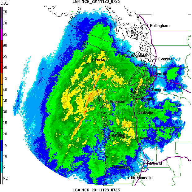
One of the most fascinating aspects of this storm was how we could see it on the coastal radar. Remember how I talked about that "thin band of heavy rain"? Check this image out.

11:25 pm PST Tue 22 Nov 2011 - Langley Hill Radar

If you look off the coast, you can see a very heavy band of precipitation off the Washington coast stretching into the Olympic Peninsula. This band actually stalled over this area for around 2 hours last night. If this happened in Seattle, catastrophic flooding would have resulted. The last time something like this happened in Seattle was between 4 and 5 P.M. on December 14, 2006, where Seattle received around an inch of rain in one hour. 

Seattle has seen some urban flooding, but the rivers have seen more. Although this wasn't a major flooding event for the rivers, as snow levels didn't rise super high, some rivers did see some flooding. Most of these rivers are still rising, and the graphic below shows their expected crests. The Skokomish River is expected to experience major flooding, and the Stillaguamish will experience moderate flooding. The Chehalis, at this point, looks to only experience minor flooding, as less rain fell than forecast over the Olympics. If snow levels were higher with this storm, I'm sure that most rivers in Western Washington would experience flooding, with several getting to major flood stage.


Another big aspect of this storm was the wind it brought to the Oregon Coast. It was breezy here, but the Oregon Coast experienced some scarily strong winds. The model below is from last night and shows the expected winds at 1 A.M. this past morning. The winds have since died down, but they are still strong from the central Oregon coast southward.

Valid 01:00 am PST Wed, 23 Nov 2011 - 9hr Fcst - UW 00z 12km WRF-GFS 10m wind speed, SLP

50 knots sustained! That is approaching hurricane force, and there were certainly hurricane-force gusts. I'll get the highest gusts from this storm later when I can find them online. 

On Thursday, we'll have to deal with another batch of heavy rain, wind, and mountain snow. This system will be weaker than the last one and will move by much more quickly, but it will still be a big November storm and will give us some pretty gnarly weather. 

The latest model run shows some very strong winds for the coast, with sustained winds reaching 45 knots. The north interior will also get blasted as well. A storm warning is in effect for the coast, and the north interior has a storm watch. We'll have to watch the next model runs closely.

Valid 01:00 pm PST Thu, 24 Nov 2011 - 33hr Fcst - UW 12z 4km WRF-GFS 10m wind speed, SLP

For travelers, the  biggest problem this storm will pose is a threat of significant mountain snow.

Valid 04:00 am PST Fri, 25 Nov 2011 - 48hr Fcst - UW 12z 4km WRF-GFS 24-hour snowfall

The snow level will be around 2,000 feet, and models are showing up to a foot of snow in places. I would not be surprised if these amounts turned out to be higher though.

Class in 3 minutes, gotta go!
Charlie

Tuesday, November 22, 2011

Snow in the Mountains

Tuesday, November 22, 2011
10:18 A.M.

This has got to be another quick post... I have class in 12 minutes, and I need to walk over there as well.

This isn't quite the "classic" setup for flooding in Western Washington. The reason? The snow levels are too low.

Many of our major flooding events have snow levels over 10,000 feet. Right now, it is absolutely dumping in the mountains, with snow levels around 6,000 feet in the south and 3,000 feet in the north. The Cascade passes, however, are seeing snow due to an easterly pass flow, keeping temperatures cooler there.

 Take a look at Snoqualmie Pass! I wouldn't be surprised if it opened by Thanksgiving.

Eventually, this snow will shift to rain later today into Wednesday, and that presents a lot of problems for avalanches. The rain will put a lot of additional stress on the snow layers and act to lubricate it, making it more conductive for sliding.


This is for Tuesday and Tuesday night at Snoqualmie Pass, with the red denoting high avalanche danger and the black denoting extreme avalanche danger. The Northwest Weather and Avalanche Center had this to say:

"Tuesday and Tuesday Night: Avalanche danger becoming extreme above 5000 feet and high below. Natural avalanches are certain with large to very large avalanches in many areas. Avoid all avalanche terrain."

The passes will likely be closed for avalanche control.

One more thing... Seattle is not seeing heavy rain right now, as the band has shifted south. However, we will see heavy rain by noon as the band shifts northward again, and it will stick around until Wednesday morning. Overall, southwest Washington looks like it will receive the heaviest blow from this storm.

Gotta go!
Charlie

Monday, November 21, 2011

Thin Band of Heavy Rain

Monday, November 21, 2011
12:03 P.M.

Valid 01:00 pm PST Tue, 22 Nov 2011 - 33hr Fcst - UW 12z 4km 1-hour precip, 10m winds

I just got out of my atmospheric sciences class, and I want to talk about a specific feature associated with this front that will make a huge difference in determining which areas get the greatest rainfall. If you look very closely at the model above, you can see a very thin line of extremely heavy rain. This image shows the rain pointed right at us midday Tuesday. This band is expected to move around a bit, but not a whole lot.

The bottom line is that the heaviest rain totals will be found where this specific band hits. If you look closely, you can even see some greens, which denotes rainfall amounts from .64 to 1.28 inches in ONE hour. That's incredible. Much of the band is blue, which means around a half inch an hour. The rainfall rates weaken over the Puget Sound area, but they are still very high. The Seattle area will probably experience some urban flooding from this storm, but the results could be much worse if this band stalls over our area.

At this point, it looks like the rain will start to impact our area in force by 3 A.M. Tuesday morning. You can see that heavy band of precipitation over the Olympic Peninsula.

Valid 03:00 am PST Tue, 22 Nov 2011 - 23hr Fcst - UW 12z 4km 1-hour precip, 10m winds

That band will sweep over us a couple hours later.
Valid 06:00 am PST Tue, 22 Nov 2011 - 26hr Fcst - UW 12z 4km 1-hour precip, 10m winds

After this, the heaviest precipitation will dip south for a bit (although we will still be getting rain), but that band looks to head back up into the general Puget Sound vicinity by noon and hang around until Wednesday morning.

Last, let's look at the 48-hour precipitation totals expected over the area.

Valid 04:00 pm PST Wed, 23 Nov 2011 - 60hr Fcst - UW 12z 4km 48-hour precip, 10m winds 

Right now, it looks like the North Cascades and Olympics will be the hardest hit. Mt. Rainier looks pretty rainy as well. In this model run, the Central Cascades look ok as far as flooding goes. This is not the "classic" pattern for flooding in the Central Cascades, which get more precipitation from a more westerly flow. Nevertheless, it will be close for some spots, and I encourage people who live there to prepare for the possibility of minor flooding.
I'm particularly worried about the Chehalis River. The models point towards some especially heavy rain in the Chehalis River drainage. In the December 2007 flood event, a 20-mile stretch of I-5 from exit 68 to exit 88 was closed because floodwaters from the Chehalis inundated it with up to 10 feet of water in spots. While we won't see 10 feet of water on the road this time around, we could easily get a couple feet, causing I-5 to be closed for Thanksgiving travel. This  would surely put a wrench in many people's holiday plans.

I've done all my homework for the next several days, so I'll be updating this blog as more information about this coming storm surfaces.

Thanks for reading!
Charlie

Storm Looking Even Bigger

Monday, November 21, 2011
10:07 A.M.

I have to be brief, as I will have classes in 20 minutes, but I thought I'd give you an update on the major storm that will impact us tonight into Wednesday. I looked over the model runs this morning, and it looks as if the storm is now forecast to bring even more rain into the lowlands. Additionally, it will still be very windy on the coast, particularly the Oregon coast, where sustained winds of 40 knots with gusts up to 70 knots in isolated places will pound the area for up to 24 hours.

Today, I was browsing the UW atmospheric sciences website, and I found some early model runs from the beginning of December 2007 showing that massive storm that impacted us at the beginning of the month. For the sake of comparison to today's storm, I'll show them below.

Valid 04:00 am PST Mon, 03 Dec 2007 - 12hr Fcst - UW 00z 12km WRF-GFS 10m wind speed

This event was extraordinary. Note the sustained winds over 50 knots on the Oregon coast. Washington was also extremely hard hit by the storm.

The precipitation was also incredible... Seattle saw over 3.5 inches of rain in 24 hours. Bremerton, right across the sound, saw 10.78 inches in 24 hours! And some regions in the Willapa Hills saw over 15 inches of rain in 24 hours.

Now, let's look at the runs for today's storm.

Valid 01:00 pm PST Tue, 22 Nov 2011 - 33hr Fcst - UW 12z 4km WRF-GFS 10m wind speed

The winds, while extremely strong, are not as strong as the 2007 event, and will mainly occur on the Oregon Coast.
Just a few minutes left... let's look at precipitation.


This model is showing up to 5 inches of precipitation for the Seattle area in 24 hours. If this verifies, this could set numerous records for 24-hour rainfall totals across the lowlands. I will be monitoring this situation very, very closely. As far as flooding goes, the Skokomish River off the Olympics is certain to flood. Many other rivers will flood as well... I'll give you more details as the event unfolds.

Gotta run!
Charlie

Sunday, November 20, 2011

Major Storm On Tuesday

Sunday, November 20, 2011
8:43 P.M.

Carol Snider - Urban Flooding in Seattle - December 3, 2007

Approximately four years ago, one of the strongest storms to ever hit our area, the "Great Coastal Gale," brought hurricane-force winds to the coast and major flooding throughout the area. While the inland areas didn't get hit quite as hard, the storm was still one to remember. For old time's sake, I'll show you the satellite picture of the storm approaching the area.

07:00 pm PST Sun 02 Dec 2007

While we probably won't see a storm of this magnitude for many more years, we will see a major storm bringing high winds and flooding rain approach us. A fast-moving front will come through the area Monday morning, bringing a brief dose of heavy precipitation and brisk winds to the coast, but this will not be the main event. On Monday night, the biggest storm we have seen for all winter will slam into the Pacific Northwest. This storm will generate very strong winds, particularly for the coast, and will dump heavy rain over much of the area. To make matters worse, this storm is expected to be a slow-mover, and it is possible that it might not clear the area until Wednesday morning. 

For most of us, heavy rain will be the primary concern with this storm.

Valid 04:00 am PST Wed, 23 Nov 2011 - 60hr Fcst - UW 00z 12km WRF-GFS 24-hour precip

Look at all of that rain! The models indicate that much of Western Washington could get inundated with 2-5 inches of rain from Tuesday morning to Wednesday morning. 

With all this rain comes flooding concerns, and it will be a close call for many of the area rivers. Although the mountains will get even more rain than the lowlands, the amounts in the models are actually relatively low for an event like this. This seems to be due to the lack of orographic enhancement over the mountains, particularly the central Cascades, which generally get more rain from a westerly flow rather than a southwesterly one. The Skokomish is likely to see major flooding, as it is the most flood-prone river in the state. Many other rivers may see minor to moderate flooding. Thankfully, at this point, it doesn't look like a historic flood event. 

But it will be very, very wet.

Now, let's look at the winds. 

Valid 01:00 am PST Tue, 22 Nov 2011 - 33hr Fcst - UW 00z 12km WRF-GFS 10m wind, SLP

The model above shows the winds expected over our area at 1 A.M. Tuesday morning. You can see two general areas receiving high winds... the area immediately south of the low, and the larger area in ahead of the stationary front off our coast. Since this front will not move much, the area of high winds will not move much either. The result will be a prolonged high-wind event for the coastal strip of the Pacific Northwest. Inland areas will also get windy, particularly the north interior, but the coast will receive the brunt of this storm with respect to wind.

The rest of the week looks rather exciting as well. On Thursday, the model shows a small but intense area of low pressure making landfall at the mouth of the Columbia. This could spell high wind for the Portland area, and will need to be watched carefully.

Valid 10:00 pm PST Fri, 25 Nov 2011 - 126hr Fcst - UW 00z 12km WRF-GFS 10m wind, SLP

The bigger story, however, is that the model I have been using for this post indicates that another major storm similar to the one we will see Tuesday will impact our area over the weekend, giving high winds to the coast and heavy rain throughout Western Washington

04:00 am PST Sun, 27 Nov 2011 - 156hr Fcst - UW 00z 12km WRF-GFS 24-hour precip

We'll have to keep an eye out for this one as well, but not all of the models show it at this point. In the meantime, button down the hatches and get ready for Tuesday. It looks as though the storm season has finally arrived.

Charlie