Pi Day 2016
4:55 pm
I apologize for not being in the blogosphere yesterday - I was up at Alpental introducing 5-year-olds to poles. I taught lessons up there this year on the weekends and had a spectacular time, and I'd highly recommend anybody who loves kids and skiing to consider teaching ski lessons up there. The kids are so fun, kind, and carefree, and they don't judge me for being a complete goofball weirdo around them. It seems like we let go of these qualities as we grow older, which is too bad because I think they make us special. I hope the kids learned from me, because I know I learned a lot from them.
Yesterday was stormy throughout Western Washington. There were blizzard conditions at times up on some of the ridgetops at Alpental, and I believe ~250,000 people lost power here in Western Washington. Many of the kids were crying because the fierce winds were very scary! I'd estimate that there were gusts 40-50 mph affecting us at times... it was intense. The NWAC site at Dodge Ridge at Summit West clocked multiple gusts to 68 mph yesterday afternoon, and they are significantly lower in elevation than where we were at Alpental.
Sunday's storm was not very well predicted. Early forecasts showed the potential for a major windstorm across the Puget Sound region, with sustained winds of 30-45 mph and gusts up to 70 mph. Storm warnings (sustained winds of 48-63 knots or 55-73 mph) were issued for Puget Sound, something that happens very rarely. Even late Saturday night/Sunday morning, these storm warnings were still up.
However, Saturday night's model runs significantly cut back on the predicted strength of the windstorm, and by early Sunday morning, the National Weather Service had replaced the storm warnings in Puget Sound with lesser gale warnings. However, these models didn't have a good handle on the storm either, and neither did Sunday morning's runs, which were initialized approximately 6 hours before the storm was forecast to make landfall. UW's flagship WRF-GFS model had the low making landfall just to the north of the mouth of the Columbia River around 11 am as a rather elongated 984 mb cyclone.
Instead, the storm made landfall significantly further north on the northern Olympic Peninsula and deepened to ~978 mb. This caused forecasters to increase the forecast strength of the winds for the coast and North Interior, but tone down their forecasts for the Puget Sound area due to the low traveling further north. Although high wind warnings were still up at this time, some forecasts from various outlets were calling for gusts below 45 mph for most of Puget Sound.
Instead, winds ended up being stronger than forecast, even for the Seattle area. Sea-Tac hit 56, and West Point in Magnolia hit 66! Here are some peak gusts from around the region that I retrieved from the National Weather Service... I bolded gusts from major stations or ones that were particularly high.
PUBLIC INFORMATION STATEMENT
NATIONAL WEATHER SERVICE
SEATTLE WA
935 PM PDT SUN MAR 13 2016
...WIND REPORTS PAST 12
HOURS...
HERE ARE SOME PRELIMINARY
WIND REPORTS FROM THE WEDNESDAY
EVENING/THURSDAY WIND
EVENT. REPORTS OF LESS THAN 40 MPH WERE
OMITTED. REPORTS ARE
GUSTS...EXCEPT (P) ARE PEAK WINDS AND (S) ARE
SUSTAINED WINDS.
LOCATION SPEED TIME/DATE LAT/LON
...ADMIRALTY INLET AREA...
MARROWSTONE POINT
LIGHT 67 MPH 0406 PM 03/13 48.10N/122.69W
WHIDBEY ISLAND NAS 66 MPH 0359 PM 03/13 48.35N/122.67W
COUPEVILLE 45 MPH 0410 PM 03/13 48.22N/122.69W
PORT TOWNSEND 45 MPH 0333 PM 03/13 48.11N/122.77W
2 W OAK HARBOR 44 MPH 0404 PM 03/13 48.29N/122.69W
2 W FREELAND 40 MPH 0340 PM 03/13 48.01N/122.58W
...BELLEVUE AND VICINITY...
1 S EASTGATE 57 MPH 0246 PM 03/13 47.55N/122.13W
1 WNW KIRKLAND 46 MPH 0403 PM 03/13 47.69N/122.22W
1 NNW BOTHELL 44 MPH 0403 PM 03/13 47.78N/122.21W
KENMORE 44 MPH 0310 PM 03/13 47.76N/122.25W
ISSAQUAH 40 MPH 0340 PM 03/13 47.53N/122.03W
...BREMERTON AND
VICINITY...
INDIANOLA 51 MPH 0139 PM 03/13 47.74N/122.51W
BREMERTON AIRPORT 40 MPH 0155 PM 03/13 47.50N/122.75W
...CENTRAL COAST...
HOQUIAM BOWERMAN AP 63 MPH 0122 PM 03/13 46.97N/123.93W
1 WNW ABERDEEN 52 MPH 0146 PM 03/13 46.98N/123.84W
...EAST PUGET SOUND
LOWLANDS...
LAKE STEVENS 45 MPH 0333 PM 03/13 48.03N/122.06W
2 W SNOQUALMIE 44 MPH 1044 AM 03/13 47.52N/121.88W
ENUMCLAW 41 MPH 0252 PM 03/13 47.21N/122.00W
...EASTERN STRAIT OF JUAN
DE FUCA...
EDIZ HOOK CG 45 MPH 1255 PM 03/13 48.14N/123.41W
...EVERETT AND VICINITY...
PAINE FIELD AP 60 MPH 0316 PM 03/13 47.91N/122.28W
ARLINGTON AP 52 MPH 0355 PM 03/13 48.16N/122.16W
HARBOUR POINTE 49 MPH 0300 PM 03/13 47.89N/122.32W
ALDERWOOD MANOR 41 MPH 0415 PM 03/13 47.82N/122.28W
...HOOD CANAL AREA...
1 WSW BRINNON 56 MPH 0312 PM 03/13 47.67N/122.93W
SHELTON AIRPORT 52 MPH 0305 PM 03/13 47.24N/123.14W
4 E PORT LUDLOW 47 MPH 0425 PM 03/13 47.92N/122.58W
...LOWER CHEHALIS VALLEY
AREA...
MINOT PEAK 43 MPH 1100 AM 03/13 46.89N/123.42W
...NORTH COAST...
QUILLAYUTE AIRPORT 47 MPH 0355 PM 03/13 47.94N/124.56W
LA PUSH NOS TIDE GAUGE 42 MPH
0336 PM 03/13
47.91N/124.64W
...OLYMPICS...
HUMPTULLIPS 63 MPH 0308 PM 03/13 47.38N/123.76W
JEFFERSON CREEK 42 MPH 0536 PM 03/13 47.55N/123.22W
...SAN JUAN COUNTY...
LOPEZ ISLAND 66 MPH 0351 PM 03/13 48.53N/122.87W
4 SSW ROCHE HARBOR 58 MPH 0549 PM 03/13 48.55N/123.16W
NW DECATUR IS. BEACH 51 MPH 0403 PM 03/13 48.51N/122.83W
FRIDAY HARBOR AIRPORT 51 MPH 0315 PM 03/13 48.52N/123.02W
2 SE EASTSOUND 48 MPH 0445 PM 03/13 48.67N/122.87W
ORCAS ISLAND AP 45 MPH 0615 PM 03/13 48.71N/122.91W
...SEATTLE AND VICINITY...
SEATTLE TACOMA ARPT
56 MPH 0138 PM 03/13 47.44N/122.31W
BOEING FIELD/KING COUNTY
INT 54 MPH 0130 PM 03/13 47.53N/122.30W
POINT ROBINSON 53 MPH 0400 PM 03/13 47.39N/122.37W
NORMANDY PARK 52 MPH 0149 PM 03/13 47.44N/122.34W
3 NW WHITE CENTER 49 MPH 0213 PM 03/13 47.56N/122.39W
UNIV. OF WASHINGTON 49 MPH 0403 PM 03/13 47.65N/122.31W
3 SW SEATTLE 48 MPH 0507 PM 03/13 47.58N/122.40W
RENTON MUNICIPAL
AIRPORT 48 MPH 0220 PM 03/13 47.49N/122.21W
1 NNW FEDERAL WAY 45 MPH 0438 PM 03/13 47.34N/122.35W
2 NW WHITE CENTER 44 MPH 0415 PM 03/13 47.55N/122.38W
3 NW WHITE CENTER 43 MPH 0320 PM 03/13 47.56N/122.39W
4 NW SEATTLE 43 MPH 0506 PM 03/13 47.67N/122.41W
1 SE SEATTLE 42 MPH 0242 PM 03/13 47.59N/122.32W
3 WNW SEATTLE 42 MPH 0455 PM 03/13 47.65N/122.41W
1 NE SEATTLE 42 MPH 0159 PM 03/13 47.62N/122.32W
1 NE SEATTLE 41 MPH 0317 PM 03/13 47.64N/122.33W
2 W KIRKLAND 41 MPH 0330 PM 03/13 47.69N/122.26W
...SOUTHWEST INTERIOR...
OLYMPIA AIRPORT 46 MPH 0239 PM 03/13 46.97N/122.90W
YELM 43 MPH 1250 PM 03/13 46.94N/122.61W
1 WNW NISQUALLY 41 MPH 0210 PM 03/13 47.07N/122.72W
5 S LACEY 40 MPH 0202 PM 03/13 46.96N/122.80W
...TACOMA AREA...
JBLM-FT LEWIS 58 MPH 1258 PM 03/13 47.08N/122.58W
JBLM-MCCHORD 55 MPH 0119 PM 03/13 47.13N/122.48W
3 NNE FREDERICKSON 46 MPH 0330 PM 03/13 47.13N/122.34W
TACOMA NARROWS AIRPORT 44 MPH
0255 PM 03/13
47.27N/122.58W
1 NW FIRCREST 43 MPH 0150 PM 03/13 47.25N/122.53W
RUSTON 41 MPH 0225 PM 03/13 47.30N/122.52W
2 NW ARTONDALE 40 MPH 0327 PM 03/13 47.34N/122.67W
2 SW FEDERAL WAY 40 MPH 0143 PM 03/13 47.29N/122.38W
SOUTH HILL 40 MPH 0302 PM 03/13 47.14N/122.27W
...WASHINGTON...
DESTRUCTION ISLAND 79 MPH 0300 PM 03/13 47.68N/124.49W
1 SW KBLI 68 MPH 0510 PM 03/13 48.78N/122.56W
WESTPORT TIDE GAUGE 68 MPH 0200 PM 03/13 46.90N/124.11W
CHERRY POINT 66 MPH 0436 PM 03/13 48.86N/122.76W
WEST POINT 66 MPH 0400 PM 03/13 47.66N/122.44W
SMITH ISLAND 60 MPH 0300 PM 03/13 48.32N/122.84W
POSSESSION SOUND 59 MPH 0413 PM 03/13 48.02N/122.27W
CAPE ELIZABETH BUOY 58 MPH 0250 PM 03/13 47.30N/124.70W
S. LOPEZ ISLAND 56 MPH 0304 PM 03/13 48.40N/122.90W
HOOD CANAL BRIDGE 56 MPH
0420 PM 03/13
47.86N/122.62W
PORT TOWNSEND NOS TIDE
GAUGE 55 MPH 0336 PM 03/13 48.12N/122.75W
RICHMOND BEACH 55 MPH 0405 PM 03/13 47.77N/122.39W
BLANCHARD 54 MPH 0350 PM 03/13 48.59N/122.43W
SEATTLE 52 MPH 0306 PM 03/13 47.60N/122.34W
HEIN BANK BUOY 49 MPH 0550 PM 03/13 48.30N/123.20W
GOLDEN GARDENS SEATTLE 48 MPH
0305 PM 03/13 47.69N/122.40W
HENDERSON BAY 48 MPH 0330 PM 03/13 47.38N/122.63W
WINSLOW FERRY DOCK 44 MPH 0310 PM 03/13 47.62N/122.51W
POINT WELLS 43 MPH 0410 PM 03/13 47.80N/122.40W
KEYSTONE FERRY DOCK 43 MPH 0415 PM 03/13 48.16N/122.67W
PORT OF TACOMA #1 42 MPH 0230 PM 03/13 47.28N/122.42W
4 ESE PORT LUDLOW 40 MPH 0327 PM 03/13 47.90N/122.60W
...WEST SLOPES NORTH
CASCADES AND PASSES...
KIDNEY CREEK 41 MPH 0128 PM 03/13 48.92N/121.94W
SUMAS-RAWS 40 MPH 0509 PM 03/13 48.91N/122.22W
...WEST SLOPES NORTH
CENTRAL CASCADES AND PASSES...
SNOQUALMIE PASS 68 MPH 0500 PM 03/13 47.42N/121.43W
...WEST SLOPES SOUTH
CENTRAL CASCADES AND PASSES...
PARADISE 45 MPH 0400 PM 03/13 46.78N/121.74W
...WESTERN SKAGIT COUNTY...
SEDRO WOOLLEY-RAWS 47 MPH 0642 PM 03/13 48.52N/122.22W
BURLINGTON/MOUNT
VERNON 46 MPH 0355 PM 03/13 48.47N/122.42W
...WESTERN WHATCOM
COUNTY...
SANDY PT. SHORES 68 MPH 0354 PM 03/13 48.80N/122.71W
BELLINGHAM INTL AP 64 MPH 0510 PM 03/13 48.79N/122.54W
LYNDEN 52 MPH 0535 PM 03/13 48.96N/122.41W
3 N FERNDALE 50 MPH 0532 PM 03/13 48.90N/122.58W
LUMMI ISLAND 47 MPH 0435 PM 03/13 48.73N/122.70W
3 W FERNDALE 47 MPH 0427 PM 03/13 48.85N/122.67W
4 SSW LYNDEN 47 MPH 0505 PM 03/13 48.89N/122.49W
BLAINE 46 MPH 0515 PM 03/13 49.00N/122.74W
4 ENE FERNDALE 44 MPH 0534 PM 03/13 48.88N/122.51W
3 WSW SUDDEN VALLEY 44 MPH 0415 PM 03/13 48.69N/122.40W
BLAINE 42 MPH 0523 PM 03/13 49.00N/122.75W
BELLINGHAM 41 MPH 0504 PM 03/13 48.74N/122.45W
1 WNW LYNDEN 41 MPH 0505 PM 03/13 48.96N/122.48W
These gusts are strong, but they aren't anything we've ever seen before. Still, it's pretty impressive to have a 66 mph gust at West Point in mid-March! The Seattle NWS office dubbed this storm the "Pre-St. Patty's Day Punch," which is pretty awesome. When it comes to naming notable weather events, alliteration counts.
Here's a picture I took from Cliff Mass' blog of max gusts recorded during the windstorm. As you can see, higher winds were located over the coast and North Interior. There are quite a few low gusts (10s and 20s), and these are from stations that are not well-exposed to the wind. Over water, gusts were in the 45-60 mph range across the region, and coastal headlands (like Destruction Island) accelerated these winds. Camp Muir at 10,110 feet on Mt. Rainier was the wind winner with a gust to 95 mph.
The most amazing thing about this storm, however, was simply how it appeared on radar and satellite. This was a compact storm, and had a very distinctive bent-back occlusion (the swirl of clouds that spirals counterclockwise to the center of the low). Take a look!
As this visible satellite image shows, the storm was off the mouth of the Columbia around 9:15 am, and was heading to the NNE. You can see the tight circulation around the low and the intense cold front along the Oregon Coast. Strong winds are occurring along the coast and mountain ridgetops at this time, but winds in the lowlands are relatively low.
I've seen some cool shots from our coastal radar, but this may very well be the coolest one yet. Take a look at the low! It almost looks like a hurricane. You can really see the movement of the storm with the animated gif below. Moreover, you can see how the reflectivity in the vicinity of the radar increases as time (and wind speed) goes on, and this is due to "sea clutter," or the radar beam reflecting off the top of wave crests. More wind, bigger waves, and thus more sea clutter.
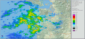 |
| Created with NOAA Weather and Climate Toolkit |
Here's the view at 12:10 pm. Compare it to the image from the NASA TERRA polar-orbiting satellite below, which was also taken around 12:10 pm.
 |
Image taken ~12:10 pm by NASA's TERRA satellite
Credit: NASA |
There were strong winds over 520, and the bridge was closed for a while. I can't remember the last time that happened, but it has been a long time!
But, of course, the day finished on a beautiful note. Take a look at this incredible photo out at Alki Point from Tim Durkan. That has to be one of the most brilliant double rainbows I've ever seen.
Thanks for reading! Things look much calmer this week, especially after Wednesday. Inclement weather returns for the weekend, but it won't be anything like what we saw this past week.
Thank you!
Charlie